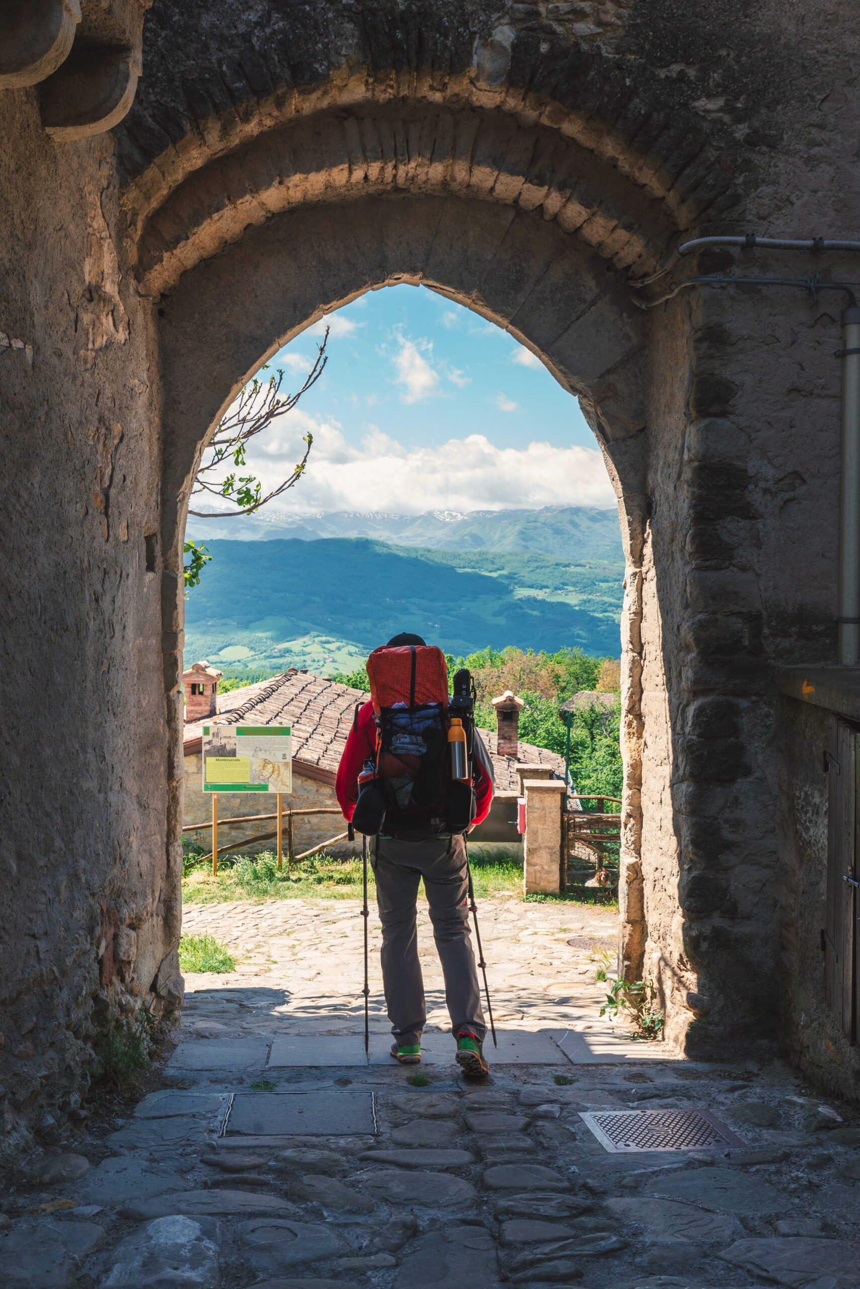
ROMEA IMPERIALE
The Via Romea Imperiale is one of the Germanic Vie Romee, European Cultural Routes; it intersects the main European and Italian religious and secular paths.
Rome is the destination; Germanic is the origin; Imperial: from Octavian Augustus to the Habsburgs, and 60 others. A plurality of natural emergencies, UNESCO World Heritage cities, ancient villages. Religious and civil architecture, bold medieval bridges and classical monuments, treasure troves of art in museums and sacred relics in shrines. But the topicality of the places traversed also deserves attention: an unforgettable journey that provides up-close acquaintance with the wines of Trentino, Veneto, Emilia and Tuscany; the gastronomy that offers Modenese cured meats and balsamic vinegar; mountain pasture cheeses, grana padano and trentino, parmigiano reggiano, pecorino; high fashion and Motor Valley. The route can be traveled on foot and by mountain bike, independently or in organized groups complete with different types of services, and accompanied by professional guides. It is almost all accessible year-round. Only the Apennine crossing may present difficulties in the winter months due to the presence of snow and ice. The VIA can be covered in one go or broken into fractions For example, segments of 6 / 7 STAGE can be identified, homogeneous with each other in terms of geographical or historical-cultural offerings. The new variants also allow ring routes, of one or more days. Our markers help the hiker: blue-yellow sticker with our logo, and the yellow brush arrow, like those of Santiago de Compostela.
HISTORY
Theater for more than 2,000 years of events that built the Italy of today, it saw the transit of entire peoples: the Gauls, Celts and Etruscans, the Romans and Hannibal’s Carthaginians, the hordes of barbarians that ended the Roman Empire. It saw the events of the age of communes and seignories, the Renaissance that was born in Tuscany, the battles of the Risorgimento in the Po Valley, and the two world wars. It is based on Roman consular roads (Claudia Augusta, Postumia and Cassia); Renaissance (Via Vecchia Aretina); 18th-century (Via Vandelli); land and water trade (between Modena, the Po and Mantua); and devotional (San Bartolomeo). And finally, the Hapsburg Via Regia, still among the most important arteries today, which was commissioned by Leopold of Lorraine and Francesco d’Este to connect Florence to Vienna, capital of the Hapsburg Empire to which both houses were linked by dynastic descent. This route was the first European highway, and was traveled by the many artists on the Grand Tour who, beginning in the 19th century created the image of Italy as a destination for rediscovering classicism. St. Francis and Martin Luther passed through it, Matilda of Canossa, almost the “godmother” of our VIA, whose traces we encounter from Valdarno to Mantua and San Benedetto Po, where she asked to be buried in the abbey founded by her grandfather. Several Popes passed through here, including Pius VII on his way to Paris for the coronation of Napoleon; Emperors (about sixty!) including Henry IV humiliated at Canossa.
STAGE
STAGE 1: Trento-Rovereto; elevation gain + m 19; km 28.6; time 7 hours; bicycle path almost all paved.
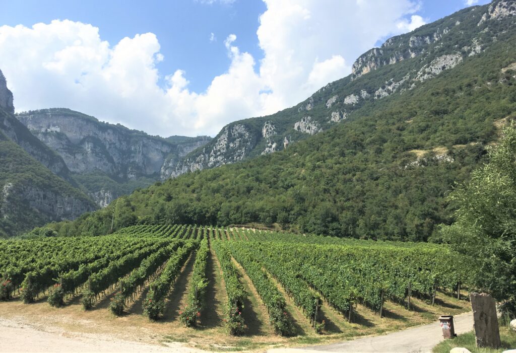
Our journey begins in Trent, the city famous for the Council from which the Counter-Reformation was born, and which was for millennia a land of passage for the descent of northern peoples into Italy. We will retrace one of the two branches of the Via Claudia Augusta: the one that heads decisively south, toward the Po (while the other reaches the Adriatic, at Altino, north of Venice). After the urban section out of the city, the route begins along the Adige River, almost always using the most important of the bike paths in Trentino. It crosses the entire region from north to south, connecting the Province of Bolzano with that of Verona, the heart of the Alps with the Po Valley. It uses embankment roads that cross countryside planted with vineyards and orchards, skirting small villages. The total elevation gain over the entire route is no more than 100 meters. Almost all of its development is protected from vehicular traffic, except for a few agricultural vehicles authorized to travel on the bicycle path to reach the landlocked estates.
Stage 2: Rovereto-Ala, km 21; elevation gain + m 20; time 5 hrs. Mostly paved bike path.
From the city of silk to the city of velvet: this STAGE offers a v itinerary dedicated to fine fabrics. Rovereto is a city worth visiting, rich in history and culture, the birthplace of Fortunato Depero, a great exponent of the Futurist current; the MART museum center, and the War Museum, rich in artifacts and historical documentation, dating back to the two world wars, are worth visiting. Returning to our itinerary, after passing through the ancient district of Borgo Sacco and crossing the Zigherane bridge over the Leno stream, we head back along the Adige River The route winds a little on the right bank and a little on the. opposite bank of the Adige River, passing through the vineyards of the lower Vallagarina. Ala is a beautiful town, known for its velvet manufacturing.
STAGE 3: Ala-Brentino, km 22; elevation gain + m 287; time 5 hours; bicycle path almost all paved.
We leave Ala, returning to our steps traveled the previous day, to gain the dear Adige, which has accompanied us for two STAGES already and which we will continue to follow in this one and the next if we take the Lake Garda route, or for one more stage if we want to go to Verona. Sometimes we leave the river and continue on the canals that run along it, conveying the water to irrigate the fertile valley. We reach the small town of Borghetto, on the conne with the province of Verona. To indicate the conne, there is an old stone boundary stone dating back to the ne 19th century, with the initials of Italy and Austria engraved on both sides, a reminder of an era still dominated by monarchies and empires. This STAGE also presents two “optional” opportunities, which we recommend taking. These are two connections that lead off the basic route by a few kilometers, but the effort will be rewarded by visiting the Castle of Avio, which is reached by walking some sections on the original pavement of the Via Claudia Augusta. The other detour leads to the Sanctuary of the Madonna della Corona, a true devotional jewel, set on the rock of Baldo, 800 m. s m that, l in addition to the devotional aspect, also offers a beautiful panorama of the valley.
STAGE 4: Brentino-Pastrengo, km 21; elevation gain + m 116; time 5 hrs; bike path, trails, country roads.
This STAGE from the point of view of landscape in the first part is similar to the previous ones, then it moves away for a few kilometers from the river to climb to Rivoli Veronese, a town preceded by the historic built by the Austrian forts to garrison the area. After passing another Austrian fort, the STAGE ends in Pastrengo, a center that recalls school studies and the Italian-Austrian wars. In fact, an important battle of the First War of Independence (1848) was fought in Pastrengo, in which Carlo Alberto’s Piedmontese defeated the Austrians led by General Radetzky thanks to the famous charge of the Carabinieri in defense of the king. Nearly three hundred mounted carabinieri, sabers drawn, galloped off to the cry of “Savoy.” The war then turned in favor of Austria, and it took two more wars of Independence, also fought here, to unite the town and the entire Veneto region to Italy.
STAGE 5: Pastrengo-Peschiera, km 22; elevation gain + m 19; time 5.5 hours; country, dirt or paved roads.
We walk on the Via Postumia, the ancient Roman consular road that crossed the entire Po Valley, from Aquileia to Genoa. The landscape and the type of route change radically: in fact, we leave the Adige bike path on which we have been walking for three days and we will travel along country roads, both dirt and asphalt, but always with very little traffic, skirting beautiful vineyards that produce the famous Garda wines no to Colà di Lazise, a splendid village also known for its important spa. Before arriving at the lake we can indulge in a playful digression at the Gardaland park that we pass right in front of. We finally arrive in Peschiera, on Lake Garda’s emissary, the Mincio, which will accompany us for a few STAGES. A city rich in history, being of Roman origin, Peschiera was later an important Venetian center, and finally the scene of the wars of independence (one of the cities of the quadrilateral). Then we cannot forget a beautiful shrine, dedicated to the Madonna del Frassino, a destination for pilgrim devotion.
STAGE 6: Peschiera-Goito, km 30; elevation gain + 272; time 7.5 hours; dirt or paved trails and roads.
The crossing of the great Po Valley begins in Peschiera. Contrary to what one might mistakenly think, however, this stretch is anything but monotonous; we are flanked by several waterways, historic arteries used for all kinds of transfers, taking us back to the not-so-distant years when goods and people preferred to move on water rather than use land roads. On this STAGE we encounter some pretty castle towns, such as Ponti sul Mincio and Monzambano, and the important town of Volta Mantovana, which we recommend visiting for its beautiful historic center full of valuable monuments. In Volta one can also stop by breaking up the rather long STAGE. For the hurried who want to reach Goito directly, you can use a direct, shorter variant of about 2 km.
Alternative route from Pastrengo to Volta M. and to Goito
This variant runs for the most part on the Via Postumia, almost to Villafranca, then shifts to a beautiful and convenient bicycle/pedestrian path that leads to the Mincio River and, having crossed it, rejoins the basic route. The variant totaling 66 km, we propose it in 3 convenient STAGES.
STAGE 7: Villafranca Volta Mantovana (and Goito), km 23 (31); time otre 6 (8); elevation gain + m 101; country roads, embankment roads.
Still following bicycle paths or country roads, from Villafranca we head west and skirt the hill of Custoza, the scene of a famous battle in the Second War of Independence. Many are the vineyards from which delicious wines are produced: we are in the morainic hills of Garda, whose soils are very suitable for those crops. One comfortably arrives at Valeggio sul Mincio, a town that is touristically known for its castle and the large Sigurtà Park. Just across the river, which we cross on the ancient bridge, we land in Borghetto, a beautiful town with typical small restaurants offering the excellent local cuisine, and with several water mills. We have entered Lombardy, and after a few kilometers here we are in Volta Mantovana, where we find the basic route again; if physical and weather conditions permit, we can decide to arrive directly in Goito, without going up to Volta.
STAGE 8: Mantua-San Benedetto Po, km 26; elevation gain + 160; time 7 hours; embankment roads.
Beautiful is the exit from Mantua, from the lakes formed by the Mincio to the river, which takes us past Pietole, the birthplace of Virgil. Continuing on the embankment or at least close to the Mincio, we approach a new river, indeed the most important of Italian rivers: the Po. We walk for a few kilometers along its banks and finally cross it, either on the bridge at San Benedetto or by ferry (before leaving for the STAGE inquire if the service is active). San Benedetto features an abbey complex that dates back to the Canossa family (and Matilda was buried there). Magnificent the church, and very important the museum. On this STAGE we walked for several stretches on the Via Postumia, which we then left, however, finding a new companion: the San Pellegrino Way, with whom we will share a good chunk of road, until that beautiful path bends toward Reggio Emilia and we toward Modena.
STAGE 9: San Benedetto Po-Concordia, km 23; elevation gain + m 100; time 6 hours; embankment, dirt and asphalt roads.
Leaving the Basilica, we quickly enter the Po Valley countryside: here we are right halfway between the Alps and the Apennines. The landscape is characterized by vast agricultural expanses, dotted with large farms on the model made famous by Bertolucci’s film “900” and “Bacchellian atmospheres.” The only town on the route is Quistello, which has some interesting monuments, some still showing signs of the earthquake of a few years ago; a stop for refreshments and possible purchases of food and drink is appropriate.
STAGE 10: Concordia-Sozzigalli, km 27; elevation gain + m 296; time 7 hours; unpaved embankment roads.
In the previous STAGE we entered Emilia, specifically the province of Modena; Here we will find an important crossroads of Roman roads, namely the continuation of the Claudia Augusta (to the Tyrrhenian Sea), and the Via Emilia. We will travel the entire province according to the north-south direction, crossing very different landscapes: from the plains, to the hills, to the challenging mountains of the Apennines. We continue to walk along the bank of the Secchia River, among laurels of poplars and bell towers in the distance. One could say, however, that beyond the Secchia there is the scent of another river in the air, slightly alcoholic: the ume of Lambrusco that is produced here in different types, and exported all over the world; it is certainly one of the most popular wines. The area was the scene a few years ago of a major earthquake, the signs of which are still clearly visible in the towns one comes across.
STAGE 11: Sozzigalli-Modena, km 19; elevation gain + m 250; time 5 hours; embankment roads, country roads, entrance into historic center of Modena.
This STAGE also runs along waterways, particularly the Secchia and the Naviglio, which once connected the center of Modena (the Ducal Palace itself) with the Po. We are in lands rich in world-famous productions: wines (lambrusco), fashion, motors. After some historical emergencies related to river navigation, very important no a few decades ago, and historic villas, we come to a World Heritage monument. This is P the thousand-year-old architectural complex, in admirable Romanesque style, consisting of the Cathedral by Lanfranco and Wiligelmo, and the “Ghirlandina” Tower, its bell tower. Everything here, starting with the stones, speaks to us of the medieval world, where the cathedral and town hall overlooked the same square, the market place. We will meet King Arthur, but also the measure of cottage cheese and an extraordinary stone Genesis, all on the walls of the same church.
STAGE 12: Modena-Maranello, km 21; elevation gain + m 172; time 6 hours; historic center, bicycle paths, dirt trails.
Leaving Modena we take the bicycle path built on the old Modena – Vignola railroad, leaving it when it crosses a well-marked Nature Trail that bends south toward the mountains. Our route is just east of the route of the eighteenth-century Via Vandelli, a road that the Duke of Modena had built to connect the capital of the duchy with the Tyrrhenian Sea; today the old road is heavily trafficked, so we have adopted this alternative, quiet and safe, which goes up a stream for a few kilometers. We leave the Nature Trail to reach the world-famous motor city of Maranello, where Ferrari is headquartered with its Formula One and gran turismo museum. Pilgrims can find hospitality and all kinds of services. From a technical point of view, the STAGE does not present difficulties; it is all flat. Most of the route is on smooth and shady dirt road, so pleasant even in summer, which will lead without problems to the destination.
STAGE 13: Maranello-San Dalmazio (Mill), km 19; elevation gain + m 753; time 5.5 hours; dirt trails, country roads.
The Apennines begin to make themselves felt, presenting the first climbs, small villages and views. A few kilometers after the departure we suggest a visit to the Sanctuary of Puianello, also to catch our breath after the first climb, and observe from above the plain and the Alps, places of the past days’ walk. After visiting the Sanctuary, we continue on the ordinary road, not too busy but, when possible, we follow mountain paths, easy and scenic, parallel to the road. When the ascent of the first hills ends, the Apennine ridge stands out before us: stimulating mountain stages await us to reach the now nearby Tuscany. Please note: the end of the stage is located just after San Dalmazio, where there is currently no hospitality, while there is some before and after the center.
STAGE 14: San Dalmazio (Mill)-Pavullo, km 18; elevation gain + m 881; time 5 hours; dirt trails, country roads.
Today’s is a nice introduction to the Modenese Apennines, the most challenging in the region in terms of elevation gain, but also the most impressive. Already after 3 km we climb from the valley floor to the thousand-year-old parish church of Coscogno, a Byzantine memory. Time for a short visit (possibly corroborated by a snack at the bar in the nearby village), and you descend again via the ancient carriageway leading to another tributary of the Panaro River (the ancient Scoltenna). Here the next climb is really long and tiring, before arriving at the pretty village of Benedello, the scene of a fierce battle during World War II. Now we stay at altitude, crossing scenic territories where Romans and Byzantines built military garrisons that resisted the Lombards no to the last. Finally we will arrive at devotional sites, first pagan and then Christian, from which the most important parish originated, and civil settlements, the oldest in Pavullo.
STAGE 15: Pavullo-Lama-Montecreto, km 23; elevation gain + m 1246; time 7 hours; trails, country roads. Alternative: Ponte Vecchio Olina-Rovinella, km 23; elevation gain + 1273; trails, country roads.
From Pavullo almost all the way to Pistoia, the itinerary often coincides with Cammino di San Bartolomeo first, and then with the Via Francesca della Sambuca. Given the wealth of itineraries, we have selected two, which the pilgrim can choose, according to his or her preferences. In both cases it is possible to break the STAGE, and such an opportunity is far from being discarded because the Apennines here become real mountains, and the gradients quite challenging. Leaving Pavullo, we climb the hill where the castle overlooking the Scoltenna valley is located, in which Habsburg imperial army general Raimondo Montecuccoli was born. After the castle, one encounters the thousand-year-old Pieve di Renno and then some very pleasant villages, including Olina where the two indicated variants break off, climbing the two sides of the valley and then rejoining at the foot of Montecreto. As mentioned, it is possible to interrupt the STAGE thanks to the hospitality on both routes, which, however, we suggest booking: on the first route you can stop at Lama Mocogno, on the second at Ca’ Gianino.
STAGE 16: Montecreto-Pievepelago-Fiumalbo, km 21; elevation gain + 1419; time 6.5 hours; trails, country roads. Alternative: Montecreto-San Michele-Fiumalbo, km 19; elevation gain + 1308; trails, country roads.
A real mountain STAGE, not very long but demanding in terms of elevation gain, which, however, amply rewards the efforts made. The first section travels along wooded trails, leading to the beautiful, semi-abandoned ancient village of Magrignana. A few kilometers later we cross the first of the three magnificent bridges we encounter on this STAGE as evidence of the ancient passages: the bridge of San Bartolomeo. One more effort and we arrive, climbing, at a characteristic horizontal-wheel water mill, perched on the banks of a rushing brook. Next comes Riolunato, which has an interesting historic center. In the shadow of Cimone, one climbs further toward the Tuscan-Emilian border; the itinerary offers two variants: one approaches the second beautiful bridge (called the Fola, from the nearby village) and enters Pievepelago, where a possible stop provides access to many services; the other stays upstream, and passes through San Michele. Just before Fiumalbo (orange flag, also famous for its living nativity scene), one encounters the third humpback bridge over another stream that has carved a fairy-tale gorge, which has nothing to envy to similar dolomite gorges. The historic center of Fiumalbo is very atmospheric.
STAGE 17: Fiumalbo-Cutigliano, km 21; elevation gain + 748; time 6 hours; trails, country roads.
Fiumalbo is the last town in Emilia on the VIA: from now on we are in Tuscany! Starting from the church dedicated to San Bartolomeo, patron saint of the town and of our path, and with Mount Cimone on our left, we begin the ascent to Abetone, the most important pass in the entire Apennines for almost 300 years. Here we find the two famous “pyramids” placed to celebrate the great eighteenth-century road that radically changed the Italian road system, quickly becoming the most important artery linking central Italy with the Po Valley and the Habsburg Empire. The empire ruled Austria-Hungary, part of northern Italy and, through descendant dynastic branches, also the Duchy of Modena and the Grand Duchy of Tuscany. Through the beautiful fir forest, with centuries-old trees among which was the one that gave its name to Abetone, and which was cut down for the construction of the road, we descend to the center of Cutigliano, a beautiful tourist town, whose most important monument, the Palazzo Pretorio, bears witness to historical pasts of great importance to the Pistoian mountains.
STAGE 18: Cutigliano-Pontepetri, km 22; elevation gain + 655; time 6 hours; trails, country roads.
This STAGE is very beautiful and varied, on paths, roads with little traffic, a stretch that preserves an ancient paving stone and cart tracks through which we reach one of the most important tourist resorts in the area: S. Marcello Pistoiese. After this town, one takes the old railroad that has now been recovered for pedestrian travel and leads to the villages of Gavinana and Maresca. The first village is famous for the battle in which F. Ferrucci perished in 1530, to whom a beautiful equestrian statue is dedicated. Today in Gavinana, the historic Palazzo Achilli is home to the Eco romeaimperiale_tappa2_2museo della Montagna Pistoiese, which was the first Ecomuseum in Italy. Maresca is also remembered for a famous episode that occurred during the time of Republican Rome: here he died in 62 BC. Lucius Sergius Catiline, promoter of the famous conspiracy. In the small village, moreover, one comes across a much more recent but little-known curiosity: right on the VIA one can see a brass plaque commemorating the convention by which the signage that is used on all the paths in Italy was adopted, the red-and-white one that CAI volunteers tirelessly affix to trees and walls.
STAGE 19: Pontepetri-Pistoia, km 20; elevation gain + 422; time 6 hours; trails, country roads, historic center.
Leaving the small town on the banks of the newly born Reno, we quickly ascend to a wooded and rocky ridge from which a view opens up that by now we had been waiting for with some impatience: for the first time here below us is the splendid Tuscan plain, with Pistoia in the foreground, and our thoughts turn to the final destination of our journey. Arriving at the Passo della Collina, we change our traveling companion again: we say goodbye to the Cammino di San Bartolomeo and continue together with the Francesca della Sambuca, the route coming from Bologna. (The CAMMINO DI SAN BARTOLOMEO continues eastward to Spedaletto, once the site of a romeaimperiale_tappa2_2 romeaimperiale_tappa2_2of a hospice for pilgrims heading to Pistoia.) From Collina begins the descent on romeaimperiale_tappa2_2 Pistoia, along the old road that intersects the hairpin bends of the new automobile road, through pleasant olive groves almost to the plain. Pistoia is a real surprise: outstanding urban planning, with grand palaces and beautiful monuments; the palate will be satisfied by the excellent cuisine. But here it is especially important to remember the relic of St. James, preserved in the cathedral. The link with the Spanish city is celebrated on February 2 each year, when credentials are handed out to pilgrims from the area who will go to Santiago de Compostela later in the year.
STAGE 20: Pistoia-Prato, km 27; elevation gain + 1014; time 7.5 hours; two historic towns, trails, country roads.
From Pistoia, the landscape and the hiking effort totally change: we leave the Apennines with its arduous gradients and predominantly naturalistic emergencies, and from now on we will have easy hills all the way to Arezzo, dotted with historical monuments, a mirror of the centuries in which Tuscany exerted its cultural and economic influence throughout the world. Starting from the church dedicated to the VIA’s patron saint, St. Bartholomew, we leave the historic center in an east-southeast direction, and cross a vast suburbs for a few miles, until we take small roads among the fields and nurseries that characterize Pistoia’s economy. Renaissance villas can be glimpsed on the nearby hills, until we reach the first center of some importance: Montale. After the adjoining town of Montemurlo, a mid-mountain “hiking” section begins, climbing up to climb over a small ridge. Descending again into the valley, one encounters the parish church of San Pietro, in Figline, a real jewel with walls covered in beautiful frescoes; unfortunately, however, it is not always open. The next stretch is a comfortable bicycle and pedestrian path alongside the right bank of the Bisenzio River, which takes us to the center of Prato. The city is very ancient, and just outside the walls are the Etruscan-era excavations at Confienti. The historic center is absolutely worth visiting carefully. Alongside medieval (especially the castle of Emperor Frederick II, the “Stupor mundi”) and Renaissance monuments (the Duomo, with its pulpit by Donatello), there are examples of skillfully repurposed modern archaeology: many former textile industry factories reclaimed for new uses, especially cultural ones. Pilgrims also have an important reason to pay attention: the Cathedral houses the precious relic of the Sacred Girdle.
STAGE 21: Prato-Florence, km 28; elevation gain + 762; time 7.5 hours; trails, country roads, two historic towns.
The main denominator of this STAGE is history. In fact, we are on the route of the Via Cassia, one of the most important Roman consular roads, built on the previous Etruscan road system: for more than 2,200 years we have been walking on these territories, which saw the birth of the history of Italy. The reference to Roman times is highlighted by the place names of the towns crossed: Settimello, Sesto, Quinto, etc., evocative of the distance in miles from the capital Florence. Shortly after Prato, between comfortable paths and dry stone walls, we overcome slight elevation changes and arrive at the “Cementizia,” a factory from the last century, which stands out with its four chimneys halfway up the hillside, a fine example of industrial archaeology. In the background, the plain opens grandly onto territories that are now densely populated and full of industries of primary international importance. It then climbs to Calenzano, enclosed by ancient walls that preserve evocative gates, the beautiful crenellated tower and a mansion with a glorious past, where the Museo del Figurino Storico is housed. The next stretch runs through characteristic Tuscan olive groves, mostly on easy and totally safe dirt paths, over hills dotted with castles and bell towers, Renaissance villas and monasteries, and Etruscan necropolis, to the ancient village of Querceto, with the ancient church of San Jacopo, where a “Miraculous Christ” is preserved. After passing other Medici villas, including the Villa Reale di Castello, now home to the Accademia della Crusca, from the hill of Careggi we arrive at the gates of Florence, on which it is useless to dwell with summary descriptions, since it is one of the most beautiful cities in the world.
STAGE 22: Florence-Palazzolo, km 26; elevation gain + 950; time 7 hours; historic center, trails, country roads.
Important: from this STAGE no to Arezzo, the markings become white-red as on CAI trails.
This is the first STAGE of the segment through the Upper Valdarno, from Florence to Arezzo. Incredible is the amount of personalities who over the centuries were born here or came to exercise their immeasurable skills. Painters and poets, scientists of every age and, today, sportspeople and political figures, among them include Francesco Petrarca and Albert Einstein, who romeaimperiale_tappa2_2nno lived in Incisa; Marsilio Ficino, humanist philosopher, who was born in Figline; Masaccio in San Giovanni in Valdarno, and then Giorgio Vasari, Poggio Bracciolini, Leonardo, who drew the panorama painted behind the Mona Lisa here. This section is also on a historic roadway: the Old Aretina-Lauretana road, which picks up the Etruscan and Roman road system, and the Cassia, one of the major conso romeaimperiale_tappa2_2lari roads, which connected Rome with Arezzo and later continued to Fiesole, Pistoia, Lucca. The STAGE starts from Santa Croce, the Franciscan church founded by the first brothers of St. Francis heading north. Taking the reverse route of the one taken by the saint, we cross the Arno and ascend it to the Badia di Ripoli, where we find another church dedicated to our patron saint St. Bartholomew, whose blessing will accompany us all the way to Arezzo. On the first spurs after Florence we encounter the ancient Hospitale del Bigallo, an admirable building that still provides the ancient service to pilgrims and wayfarers. At San Donato, a historic pass connecting with central Italy, the climb ends and a pleasant up and down in the Tuscan countryside begins, among olive groves and historic villas, until we arrive in Palazzolo.
STAGE 23: Palazzolo-San Giovanni Valdarno, km 21; elevation gain + 306; time 5.5 hours; trails, country roads.
Palazzolo, an ancient post office on the Via Cassia, is behind us and we penetrate more and more into the Valdarno, following the river; the route is easy, and suitable for everyone. We will encounter some towns that fall into the “category” of Terre Nuove dating back to the late Middle Ages, when Florence asserted its supremacy in the area having defeated the Aretines. In order to consolidate power, the Medici built several towns ex novo in the places where there had previously been only villages, and brought back to the forefront the ancient Roman road system that was given the title of “via Maestra,” also signifying in words the importance they wanted to give to this route, compared to others in the area. Ancient monuments and modern works of art meet on this varied route: not far from each other two churches built in different periods show the architectural evolution d romeaimperiale_tappa2_2evozionale: the Pieve di San Vito and Santa Maria Teotokos, in Loppiano, near Incisa. From the point of v romeaimperiale_tappa2_2 romeaimperiale_tappa2_2 naturalistic point of view, we suggest a short detour to observe the “Balze,” the geological element that uniquely characterizes the Valdarno landscape, an erosive phenomenon that has given rise to steep clay slopes with a distinctive yellowish color.
STAGE 24: San Giovanni Valdarno-Laterina, km 25; elevation gain + 462; time 6.5 hours; trails, country roads, historic center.
These areas were routinely traveled by medieval pilgrims, heading to holy places including Loreto (recall that the route had the name Via Aretina-Lauretana). This is demonstrated by place names (e.g., Spedaluzzo), documents, and buildings historically used to serve them: in Montevarchi at least three ancient hospitali are mentioned, dedicated respectively to the Madonna, St. Michael and St. Anthony, erected between 1200 and 1300. The route continues up the Arno for a few more kilometers on the left bank to Lèvane. After this locality you pass over a bridge and continue on the right bank. Here it is worth visiting the Park-Reserve of Bandella and Inferno, whose name refers to a legendary tradition according to which Dante crossed the river thanks to a ferryman named Charon, like the character in the Aeneid: we leave it to you to deduce the consequences that such an encounter had on the “Comedy.” We travel along the modern Aretina, leaving it when we have alternatives that allow us to escape the traffic, and resuming it. Here, too, the ancient roadway now spills over into the modern one, with a car flow that makes it unsuitable (and unsafe) for bicycle and pedestrian travel. Therefore, in these cases, subject to the correct identification of the ancient road routes, which we strictly respect, nearby routes are proposed, often with a dirt bottom. Climbing the hill on which Laterina is located is a bit tiring, but the historic center is really beautiful and worth the small effort. Just before the village we suggest a very short detour to the impressive (but impassable) Romito Bridge, over the Arno River, dating back almost a thousand years.
STAGE 25: Laterina-Arezzo, km 20; elevation gain + 322; time 6 hours; trails, country roads.
This is the last STAGE of our itinerary. There is definitely a sense of satisfaction with the journey now almost complete, but also the melancholy that one feels whenever an exciting experience draws to a close. We have traveled a magnificent journey in space and time, seeing the work of nature and that of man, well integrated in this corner of Tuscany crossed by different peoples, protagonists of history for millennia. This STAGE is also very enjoyable and offers us some not-to-be-missed goodies. The beautiful Villa Monsoglio rebuilt in the Baroque style but from an earlier period; the cultural center of Rondine, where Peace is preached and practiced, on the banks of the Arno, a few kilometers from Arezzo; the Mona Lisa Bridge, in Buriano, reproduced by Leonardo behind Mona Lisa in the most famous painting of all time. And finally here is Arezzo, the Chimera, with its narrow streets remaining as they were in Vasari’s time, with the cycle of the True Cross by Piero della Francesca, with the Duomo on the highest hill. And near it also our Patron Saint, who has assisted us all along the way and now greets us from a very ancient little church, wishing us a GOOD WAY even in the everyday life that awaits us from tomorrow.
WATER SOURCES.
Present both water sources and activities at the many places traversed
ROAD BOTTOM.
35 % asphalt

Romea Imperiale
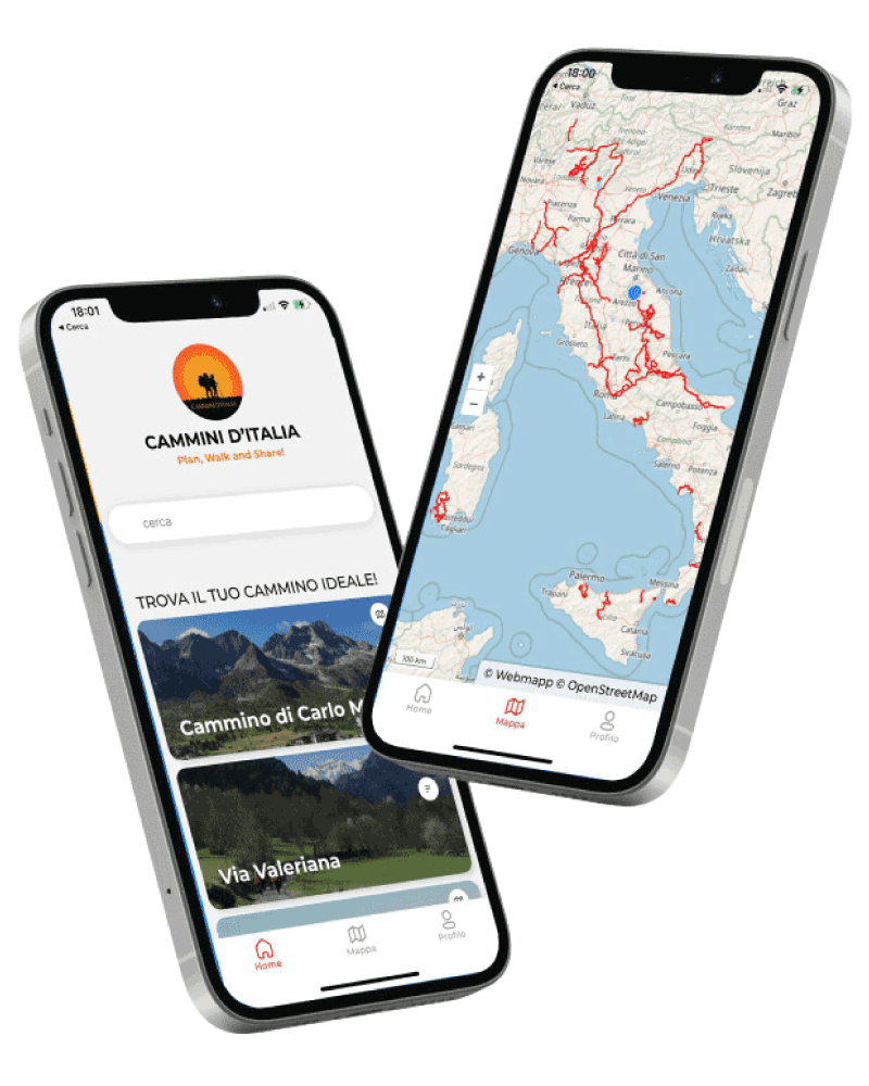
With the free Cammini d’Italia app, you can plan and walk the Romea Imperiale safely, being able to plan the stages in detail and walk the route thanks to the built-in GPS technology that supports your orientation during your adventure.
⠀Inside the app you will find many other paths present in Italy. Thanks to the georeferenced tracks of many routes you will be able to study the itinerary that suits you best and also download the GPX tracks of the individual STAGEs offline.
The app also includes a complete digital map of all the paths surveyed to date on our portal, giving you a wide range of choices among the many paths in the Belpaese.
⠀⠀
Cammini d’Italia is the perfect app for those who want to explore the beauty of Italy on foot, discovering hidden places surrounded by nature. Download it for free today and start planning your next adventure!
⠀
⠀
 ⠀⠀⠀
⠀⠀⠀