
Cammino Francescano della Marca
The Cammino Francescano della Marca has a total development of Km.167 of which 30 percent is on trail, 45 percent on dirt road and only 25 percent on asphalt with almost no car traffic.
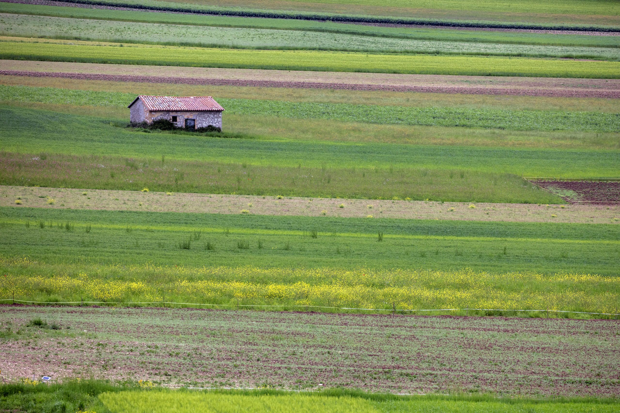
The lowest point of the entire route is at an altitude of 149 m. while the highest point is at 957 mt. It crosses 2 regions (Umbria and Marche), 4 provinces (Perugia, Macerata, Fermo and Ascoli Piceno) and 17 municipalities (Assisi, Spello, Foligno, Serravalle di Chienti, Muccia, Pievebovigliana, Fiastra, Camerino, Caldarola, Cessapalombo, San Ginesio, Sarnano, Amandola, Comunanza, Palmiano, Venarotta and Ascoli Piceno). From Assisi to Pievefavera coincides with Via Lauretana. At Pievefavera the two paths divide: the Cammino Francescano della Marca bends sharply southward, while the Via Lauretana continues eastward toward the Adriatic Sea. Walking toward Ascoli Piceno, i.e., southward, one crosses perpendicularly all the ridges and valleys of the rivers of the Marches, which orographically are arranged in a comb shape with a west/east orientation. In just 167 kilometers of development, Cammino Francescano della Marca offers a unique and extraordinary variety of landscapes and naturalistic merits, architectural and spiritual treasures, allowing the pilgrim to take an unparalleled journey through history. From the pre-Romanesque cultures of the Picenes and Umbrians to the Roman vestiges of Assisi, Spello, Foligno, Plestia and Ascoli Piceno, from Carolingian and Lombard wonders to intact medieval villages, from the splendors of the Renaissance to those of the Baroque, not to mention the many country parish churches, hermitages and the emblazoned treasures of the cities of Assisi, Spello, Foligno, Sarnano and Ascoli Piceno.
Naturalistically speaking, the Cammino touches four parks: that of Mount Subasio, that of Altolina, that of Colfiorito and the Monti Sibillini National Park. It passes from springs, rivers and waterfalls to swamps, from plateaus to forests, from wild gorges to scenic ridges that often offer glimpses of the Adriatic Sea, from rolling man-made hills to rugged clay gullies. All in the sign of St. Francis, who traveled through these districts several times, leaving behind the indelible root of a millennial spiritual history from which Cammino Francescano della Marca cannot be disregarded. From Assisi, an international spiritual center, the route winds through poetic olive groves to the magnificent Spello and the city of Foligno, a rich commercial crossroads. From here the crossing of the Apennines begins, touching on the evocative waterfalls of the Menotre Valley until reaching the pass and plateau of Colfiorito, center of PDO gastronomy and home to one of the most beautiful Renaissance hydraulic works: the Botte di Varano. You descend into the Marche side, skirting the riverbed of the Chienti River, encountering the stupendous Carolingian church of S. Giusto di S. Maroto and passing by the castles of Pievefavera, Croce, Vestignano and Montalto di Cessapalombo until you reach the wildest area of the entire walk in the Sibillini Park: the Fiastrone Gorge. It crosses the Franciscan monastery of S. Liberato and reaches the medieval town of Sarnano where historiographers place the writing of the Fioretti of St. Francis. Three more historical centers such as Amandola, Comunanza and Venarotta until the arrival at the white city: Ascoli Piceno, destination of the end of the pilgrimage.
HISTORY
The CFM retraces the route that St. Francis followed in 1215. It holds great historical, spiritual and environmental value, as evidenced by the obvious traces-such as ancient churches, bridges, Roman roads, Jacobean cults, pilgrims’ hospitals, medieval paths and archival sources-that attest to its extensive use. The Assisi departure already clearly connotes the CFM’s celebratory intentions toward St. Francis, but it is along the way that the great Franciscan presence with which the path is imbued is confirmed: Foligno, where Francis stripped himself of all earthly goods to embrace poverty and where he founded one of the first hospices; Muccia, hermitage of Blessed Rizzerio, where are the remains of one of the Poverello’s closest followers and companions; Valfornace, Convent of St. Francis founded by the saint himself in 1215 where there is still the well of the miracle of the transformation of water into wine mentioned in the Fioretti; Sarnano, cave of Soffiano and convent of San Liberato, Franciscan hermitages that tradition says were visited by the saint. Convent of St. Francis and Franciscan library in the historic center. Convent of Roccabruna where Blessed Ugolino da Montegiorgio compiled in Latin the Actus that formed the Fioretti; Venarotta, church and convent of St. Francis, recovered by the Saint himself in 1215; Poggio Canoso di Rotella, a convent whose location St. Francis himself chose and where the Saint stopped to sleep; Ascoli Piceno, city of the preaching of St. Francis with the monumental church built to celebrate the event. Naturalistically speaking, the Way touches four parks: Mount Subasio, Altolina, Colfiorito and Monti Sibillini. It passes from springs, rivers and waterfalls to swamps, from plateaus to forests, from wild gorges to scenic ridges that often offer glimpses of the Adriatic Sea, from rolling man-made hills to rugged clay gullies.
STAGE
STAGE 1 – Assisi to Foligno.
Distance: 18.9 KM.
Asphalt: 65% –
Dirt: 35%-
Walking time: 5.30 hours
Difficulty: easy
Maximum height: 486 mt.
Start: 360 mt.
Arrival: 235 mt.
Height difference(+): 250 mt.
Height difference(-): 350 mt.
An easy STAGE, with undemanding ups and downs, rich in water sources and opportunities to stop: leaving Assisi we meet Spello, a medieval pearl with its Roman remains, and then Foligno, which has always been a crossroads for pilgrims and trade. The route winds along the foothills of Mount Subasio Regional Park and the enchanting olive groves that make the Umbrian Valley unique.
It is from the tomb of Saint Francis, Patron Saint of Italy, that our journey begins. We climb the staircase leaving the Basilica behind and, continuing uphill, we cross the medieval center of ASSISI, through Via San Francesco, Via Arnaldo Fortini and Via Portica, to the Piazza del Comune. We continue straight ahead along Corso Mazzini and Via Santa Chiara, which will lead us to the square of the basilica of Santa Chiara. Keeping the church on the right, we continue along via Borgo Aretino, which will accompany us to the Porta Nuova arch, which can already be glimpsed in the background, and then to the exit from the historic center of Assisi [1.1 – Km 1.4]..From here on we will find the red and white signage of Cammino Francescano della Marca with the Cfm logo and acronym inviting us to ride downhill on SP 147. We follow it for a hundred meters to a traffic circle that we cross proceeding straight ahead. After 200 m, at the fork, we take on the left Via San Benedetto, a road that turns decisively uphill. We follow it all the way, letting the last urban settlements on the outskirts of Assisi slip by, to take us, after 900 m, below the slopes of Mount Subasio (1,290 m). The mountain, famous for its “turtle back” profile, has always been seen as a place of mysticism and sacredness, a tradition confirmed by the numerous Benedictine and Franciscan hermitages. The road continues with slight ups and downs, the gait is comfortable and the per- course in the shade. After 1 km, we find the entrance to via Borghettaccio. [1.2 – km 4], which we take keeping to the right. The asphalt from here gives way to dirt road.
After 500 m we arrive at the crossroads with a paved road: we continue straight on, without leaving the cart track, entering via Fonte l’Abate. Here the Cammino and Park signs are clearly visible. We proceed for 2.8 km, skirting, on a shaded dirt road, the borders of the Park, until the junction with a small asphalt road, Via Gabbiano. Here we turn sharply right downhill. Care must be taken at this point: after just 200 m, on the left, we must take a downhill path hidden by vegetation and unmarked [1.3 – km 7.4] which enters a large olive grove. The descent leads us to the first houses of the hamlet of Collicello, which, however, we avoid by taking immediately to the left a path edged by rosemary plants, still downhill, that after 300 m returns to level ground, goes around a private house and joins the paved road of Via Renano. We follow it downhill for 250 m to the intersection with a dirt road on the left well indicated by CFM signs, which we take. We walk among oak and olive groves first uphill, then on slight ups and downs and finally downhill until we come to the Fonte di San Francesco, well marked by a large votive shrine located right at the junction with Via degli Ulivi [1.4 – km 9.9]..
Here a few shaded benches and a cinnamon of cool water will allow us a refreshing stop. We take a left onto Via degli Ulivi and walk along the flat, sandy asphalt road that winds its way through the olive trees. As we proceed, the outline of the medieval center of SPELLO begins to be seen in front of us from above.
The Via degli Ulivi ends at the junction with Via Poeta, an asphalt access road to the city. We take it uphill to the left, walking along the tree-lined avenue on sidewalks until we enter the historic center through Porta Montanara. We continue further along Via Poeta and cross Piazza Vallegloria, keeping the Clarisse Monastery on the right, to enter, turning left under an archway, the adjacent Piazza Gramsci and then onto Via Giulia, which we walk entirely until the intersection with Via Garibaldi, which we take downhill to the left. We are in the heart of the city, on the central street overlooked by stores and cafes. Continuing downhill we cross the Town Hall and then, after taking Via Cavour, the natural continuation of Via Garibaldi, the famous church of Santa Maria Maggiore. The church is an excellent resting place with several facilities for pilgrims available such as toilets, small refectory, water source and credential stamp office.
We continue to descend via Consolare: it is possible to cut the hairpin bend by taking the pedestrian piaggia of via Sant’Angelo, which we find on our right just 50 m after the church. We leave the historic center of Spello passing under the Roman arch of Porta Consolare. [1.5 – km 13.2].. Outside the medieval walls, the route returns to level ground; we turn left into Via Sant’Anna, skirting the ramparts and continuing along Via Sant’Anna for 200 m. We pass the church of Sant’Anna on the right and immediately afterwards turn right, continuing for another 100 m until we cross the busy via della Liberazione, which we cross carefully, proceeding straight on via Brodolini. From here until Foligno, in addition to the signs of the Cammino, we will also be accompanied by those of Via di Francesco and Via Lauretana.
The road takes us away from Spello; we walk for 1.2 km, always on the level, until we reach the crossroads of Via Prato, at the height of the Church of the Holy Trinity, which remains on our right. We cross the busy road to continue straight on via Spineto, which we walk for 1.6 km until we cross via San Cristoforo [1.6 – km 16.4].. In front of us are the first small buildings on the outskirts of FOLIGNO among which we infi- llate, continuing to walk straight on via Spineto, until we reach an underpass that allows us to cross without danger the state highway 75 Foligno-Perugia.
Beyond the underpass, we turn left and after 200 m we turn de- stra. At the level crossing we cross the railway line to find ourselves on viale Firenze, an important roadway accessing Foligno [1.7 – km 17.1].. We turn left and follow it all on the level and always straight for 1.9 km until we enter the historic center, which is accessed by the Liberation Bridge, over the Topino River [1.8 – km 18.9].. We proceed with caution, using the sidewalks, where there are any, or staying on the side of the road; along the way we will cross a traffic circle with the Church of Our Lady of Fiammenga in the center, continuing straight ahead. Past the Liberation Bridge we reach the center of town and the various reception facilities, but keep in mind that this is where we will have to return to start the second STAGE.
STAGE 2 – Foligno to Colfiorito
Distance: 25.3 km.
Asphalt: 15%.
Dirt: 85%.
Walking time: 8 hours
Difficulty: challenging
Maximum height: 893 mt.
Start: 235 mt.
Arrival: 760 mt.
Height difference(+):750 mt.
Height difference(-): 200 mt.
The uphill STAGE to the Colfiorito pass traverses the entire Folignate area and reaches the border between Umbria and Marche. Although there is no shortage of springs be careful never to run out of water because the route is very exposed to the sun. The route is rich in naturalistic merits, such as the Topino River embankment on the way out of Foligno, the Menotre waterfalls, and the Colfiorito Regional Park marshland .
From the Liberation Bridge in Foligno there is a single entrance indicated by Cfm signs that drops us down onto the grassy embankment of the Topino River. We turn left onto the path that passes under the bridge and walk along it for 500 m without ever leaving the bank until we reach the overpass of Viale IV Novembre above. We cross it by passing under it and, keeping the river-full of puddles, small waterfalls, swans and wild ducks-on the right, we continue for another 700 m to the wooden pedestrian bridge at Hoffman Park, which we do not cross and proceed straight ahead on the path that continues to keep the Topino on the right. We walk for another 600 m on the riverbank until we cross yet another bridge on the busy Via Flaminia [2.1 – km 2.2].. Again we cross it passing underneath to merge onto a dirt road that runs alongside a reedbed. We remain level, continuing straight for 900 m until the dirt road joins a paved traffic circle. We skirt the traffic circle on the small path beside the guardrail to join the paved Via Allegri, which we follow to the right and which announces the entrance to the Folignate hamlet of San Giovanni Profiamma. We walk along the flat roadside between houses for 400 m to a tobacco shop on the right [2.2 – km 3.5].. We pay attention: immediately after the tobacconist’s shop we take the dirt road on the right without signposts, which after 20 m becomes a path and flows into a small white road.
After skirting a few scattered country houses, having traveled 800 m the small road converges on asphalt at a T-junction, where we turn right onto via Scanzano, which we travel entirely, crossing first the narrow bridge over the Topino River, then the railroad tracks, until we cross via Flaminia Nord. We are in the center of Scanzano: on a small square a fruit and vegetable store and the post office [2.3 – km 5.1]. We turn right onto Via dei Frantoi to enter the historic village and pass under a pedestrian arch. After the arch we turn left: here a tiny clearing with a drinking fountain in front of an old oil mill is an ideal place for a break. We still continue on Via dei Frantoi for 800 m, following a dirt road on a false level that takes us away from Scanzano. Now we pay attention: we take on the left a dirt road marked by a wooden picket with the colors and acronym Cfm that leaves the main road and in 100 m leads to a small group of country houses. Immediately after the houses we turn left onto the dirt road that takes us back to the MENOTRE riverbed at Belfiore. Here we find the asphalt road again. We cross the bridge and keep right on via Borgaccio. The small village of Belfiore accompanies us on our left. At the height of the last houses the route goes up the main road of the village: here, at the crossroads, we bend right onto via Altolina and follow the asphalt road for 200 m. At the crossroads we take the road to the left, well indicated both by the Cfm signs and by the tourist sign “Ca- scate del Menotre”.
From here the road begins to climb and after 900 m ends on a large square intended for car parking [2.4 – km 8.1]. Continue to the right on a well-marked path uphill between olive trees and dry stone walls. The roar of the falls becomes louder and louder. The path curls up the mountain spur touching the various jumps of the Menotre River and enters the village of PALE from below until the small square of the Castle where we will find benches and a fresh water fountain to regenerate after the uphill tear [2.5 – km 9]. From the square, following the signs, we take Via del Sasso, the steepest road on the left. After less than 50 m the road becomes a path that remains level until the entrance to the hamlet of Ponte Santa Lucia, at the junction with the SS 77, which we avoid by turning left onto a small asphalt road well signposted by both the Cfm and Via Lauretana, slightly uphill for 150 m, and then turn left again onto the asphalt road that leads to the hamlet of Sostino. We proceed uphill on the roadway to abandon it after 1.5 km at a hairpin bend where we take, still uphill, a well-marked dirt road on the left that saves us a few hairpin bends of asphalt and leads to the small square of Sostino [2.6 – km 11.9].. Here a source of fresh water and the shade of a washhouse are ideal for a break before tackling the long stretch of sunny pastures that leads to the Colfiorito plateau. From the washhouse the paved road continues to climb steeply through the entire hamlet until the last houses where we meet, as soon as the path returns to level ground, a crossroads. We proceed straight ahead, bending slightly to the right on a dirt road well marked by the path flags. We continue, ignoring all minor forks, on the main dirt road for 3.6 km until we find wooden cottages built after the 1997 earthquake on the left [2.7 – km 16]. We are in the locality of Franca. In front of us is an intersection. We continue straight uphill for another 1.7 km until we come to a T-junction, at the level of a private property with fenced-in woods, with Cfm signs directing us to turn left, which we follow, keeping to the main dirt road until we cross again, after 600 m, the paved road of the Colfiorito-Capodacqua provincial road. We turn left, following the provincial road for 200 m until we reach the church of the Madonna di Ricciano, on our right.
At the height of the parish church, which gives its name to the first plateau we are seeing, we take a mule track that bends to the right, forwarding us through the fertile fields of the Ricciano plains. We are at the top of the historic Colfiorito pass, which for centuries made it possible to cross the Apennines. After about fifty meters the road forks: we keep to the left in the direction of some houses and a few trees that we see in front of us, and then we proceed straight ahead, still on country roads, keeping the plateau on the right and climbing gradually to the junction with the Seggio-Forcatura municipal road [2.8 – km 19.5].. Here we turn right onto the dirt road, which we follow for 2 km to the hamlet of Forcatura. We cross it continuing on the same road, which in the meantime has become paved, heading toward the Colfiorito swamp that we begin to glimpse further down. The paved road and its downhill switchbacks bring us back to the plateau and its protected marsh. At a sluice known as the Molinaccio swallowhole, with ruins of an old mill from the 16th century, we can leave the paved roadway to take a footpath at the side of the road that skirts the swamp entirely [2.9 – km 23.6].. After 900 m, the path comes out again on the SS 77: in front of us the first houses of the village of Colfiorito. We turn left onto the sta- tale paying attention to traffic, and after 100 m we take the small road we find on the right to enter the public park, thus avoiding the dangers of the state highway. We cross the park keeping the sports facilities on our left to converge again on the SS 77 at the al- tee of a wide clearing that houses various commercial activities [2.10 – km 25.3] and the conclusion of this STAGE. Within a few hundred meters we find all the hotel reception facilities.
STAGE 3 – From Colfiorito to Polverina
Distance: 27.1 km.
Asphalt: 35%.
Dirt: 65%.
Walking time: 8 hours
Difficulty: challenging
Maximum height: 950 MT.
Start: 760 mt.
Arrival: 375 mt.
Height difference(+):450 mt.
Height difference(-): 800 mt.
Long STAGE that immediately enters Marche territory and runs entirely through the Chienti River valley. Few sources but several locations for water supply: Serravalle di Chienti, Gelagna Bassa, Muccia, Polverina. The trail touches the highest point of the path and winds its way through various ups and downs passing places of historical value, such as the mill of Gelagna, the village of La Maddalena, the convent of St. Francis and the Castle of Beldiletto, and naturalistic ones, such as the lake of Polverina.
From the square in Colfiorito we cross the SS 77 at the Lieta Sosta hotel and take the paved SP 96 that leads us toward the entrance of the Foligno-Civitanova highway. Having passed the headquarters of the Archaeological Museum (MAC) on the right, we arrive, in about 500 m, at the traffic dividing traffic circle and follow the road signs for Pievetorina/Dignano/Taverne. After 400 m we cross the CHURCH OF SANTA MARIA DI PLESTIA on the left, sanctioning our entry into the Marche region.
We continue for 1 km on the level paved road until we enter the village of Taverne. At the entrance to the village, shortly after a small church, we take the road to the left that takes us through the historic street and avoids the longer and busier ring road. At the exit of Taverne we proceed straight on, crossing the entire Colfiorito plateau to the parking lot of the site CONDOTTO ROMANO E BOTTE DEI VARANO [3.1 – km 5.5].. We continue for another 200 m and take a dirt road on the right, well indicated by Cfm signs, which soon begins to climb through dense vegetation.
After 1.8 km we come to a trijunction of dirt roads. We are at an altitude of 960 m, the highest point of the entire Cfm. We take the first left, downhill. Be careful, here the signage has been torn up: the small road first runs alongside a small barbed-wire fence with a fon- tanile then after 250 turns right. We, on the other hand, continue straight on a grassy path that proceeds along the ridge of the hill and after 200 m bends sharply to the right entering the forest. Before entering the shade let us take a moment to pause and look at the majestic landscape of the Colfiorito plateau that we left behind [3.2 – km 7.9].. We now descend on a steep gravel slope, taking care on the left at the entrance, after 500 m, of another path (in this case marked) that even steeper descends to the valley floor. Caution is needed here: the steep gradient and slippery terrain are very treacherous. We follow the entire path until we again meet the Chienti riverbed right at the entrance to the village, municipal seat, of SERRAVALLE DI CHIENTI [3.3 – km 9.1].. We descend the steps, passing in front of a water source, and proceed on the grassy path keeping the riverbank on our left. We are level again and return to the asphalt at the level of the sports hall. Municipality, bar, grocery store and tobacconist are on the parallel street at the top on our left, but our path proceeds straight on Viale Chienti. We pass between the small wooden houses built after the 1997 earthquake, in one of which there is a pharmacy, and stay level keeping the river always on our left.
We pass the cemetery and after 350 m the road enters an underpass that allows us to cross the SS 77. We are in the hamlet of Bavareto, which we go around, keeping to the right, right next to the highway seat, until we reach a fork on the right well indicated by the Cfm signs [3.4 – km 11.8].. We proceed along a dirt road that skirts a children’s playground on the left, passes a water purifier and enters a gate. We turn right passing under the highway pylons and reach a shaded clearing that we cross by bending to the left. Caution: a wooden picket with the colors and the acronym Cfm marks the entrance to the path that enters the woods bordering the Chienti River always on our left. At certain times of the year the small walkway may thin even more as the vegetation grows. Caution is needed in this section: the gorge narrows so we are forced to traverse two vertical rocks over the river. Safety ropes have been put in place but we maintain extreme caution in crossing.
We leave the forest at the height of a small hydroelectric power plant in front of which we ford the river to take us to the other orographic slope. We take the dirt road that takes us to the SS 77 bridge, which we cross from underneath and proceed to the right on obvious dirt road. After 500 m we leave the dirt road and take on the right a path that again descends among the trees, cross a small iron footbridge and turn left skirting the artificial canal that delivers water to the mill further downstream. We find the highway pylons again, which we pass from the underbridge, and after not even 100 m we are at the B&B Il mulino di Gelagna [3.5 – km 14.4], an excellent place for a restorative stop in the shade and a visit to the old hydroelectric power plant.
We continue straight on passing a small bridge and then climb on the left to the last house in the small village of Gelagna Bassa. After 20 m the Cfm signs invite us to take a small forest path to the right. We keep to it for 1 km on falsopiano skirting the Chienti River until we come to an ancient Romanesque bridge on the right. We do not cross it but take the dirt road that climbs to the left. The climb ends after 1.5 km passing in front of a farm: here at the fork we keep to the right and after 500 m on falsopiano we reach the sanctuary Madonna Col de’ Venti, whose perched post we have already glimpsed for some time. The terrace of the sanctuary is an excellent vantage point over the Sibillini Mountains. The church’s “patches” and the now-waterless drinking fountain remind us that we are entering one of the territories most affected by the 2016 earthquake. From the paved square of the church a path bends to the right decidedly downhill towards Muccia, which we already see from above. The slope and the slipperiness of the path deserve some attention. The descent converges on the hairpin bend of the asphalt road, but keeping to the right it avoids it completely, allowing us to reach from above the first houses of the town of Muccia. A flight of stairs leads us level to Compo della Fiera street. We turn left and after a few meters we find ourselves in Piazza della Vittoria, the central square of the town of MUCCIA, the heart wounded by the earthquake. A fresh water fountain in the center is what remains of the historic center of this fervent Apennine village [3.6 – km 18.9].. At the corner with the former Dal Cacciatore restaurant we follow Via Spinabello to the intersection with provincial road 256 coming from Camerino, which we take to the right until we intercept SS 77 again, which we cross and then climb onto the embankment and onto the square in front, where the post-earthquake containers are located. One of these houses the current municipal headquarters, which will be happy to stamp the pilgrims’ credential.
Having crossed the square we turn left onto Via delle Piane. We walk on asphalt, proceeding straight ahead, for 2 km, keeping the sports field on the left, passing under yet another freeway overpass and, still proceeding straight ahead, passing the damaged hamlet of Giove until the intersection with SP 209 for Visso. We cross the provincial road and take the dirt road in front, well indicated by Cfm signs, which leads us toward Villa Maddalena, a 16th-century rural architectural complex. We leave the villa on the right as we continue along the path that leads into cultivated fields; after 800 m, thanks to a small wooden footbridge, we cross the Chienti River again to take a dirt road on the left and reach the now rutted convent of San Francesco [3.7 – km 22.5]..
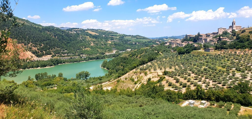
We continue for another 300 m on the paved road to the junction with SP 99 for Pievebovigliana, which we cross proceeding straight ahead in the direction of Beldiletto Castle, which we see on our left. We travel another 200 m to a crossroads. [3.8 – km 23.3]: here on the right starts the pedestrian path to PIEVEBOVIGLIANA (hamlet of the municipality of Valfornace) in case you want to use its reception facilities, but keep in mind that this is where we will have to return to end this STAGE. We proceed straight ahead, still flat and on asphalt, for 900 m until we reach a tourist/environmental panel placed on the left, where the Cfm signs invite us to take a path on the left downhill towards Lake Polverina (protected by the Polverina Wildlife Oasis), which allows us to appreciate the beauty of the basin and avoid the asphalt road. We walk all the way along it for 1.2 km until we almost reach the dam, always keeping to the part closest to the shore until the last clearing, where we are forced to climb back onto the asphalt road. However, for those who do not wish to take the marked variant of the trail, the carriage road remains a quicker alternative. When we reach the height of the dam, we proceed for 700 m until we cross a dirt road lined with oak trees on the left, which we take to penetrate between fences and the first houses of the village of Polverina. At the point where the dirt road ends on the asphalt we turn left, cross the bridge over the Chienti River and cross the SS 77 again [3.9 – km 26.8].. From here we can reach the various options available for an overnight stay, and then return to face the next STAGE.
STAGE 4 – From Polverina to Montalto di Cessapalombo.
Distance: 18.7 km.
Asphalt: 75%.
Dirt: 25%.
Walking time: 6 hours
Difficulty: medium
Maximum height: 595 mt.
Start: 375 mt.
Arrival: 550 mt.
Height difference(+): 650 mt.
Height difference(-): 450 mt.
A rather easy and pleasant STAGE to travel, with no particular differences in height, marked by the presence of numerous castles, connected by paths immersed in the green: Pievefavera, Croce, Vestignano and Montalto di Cessapalombo. Not to mention the Carolingian church of San Giusto in San Maroto and the rock church of Madonna del Sasso. All within easy reach of the architectural gem of Caldarola.
We start again from the bridge over the Chienti River in Polverina where the previous STAGE ended. The route would follow a historic trail that starts immediately on the left, threading its way into the woods to keep to the orographic right of the river, however some issues related to the clearing of the route, which we hope to resolve soon, force us at the moment to bypass it. We then walk backwards on SP 98 in the direction of Fiastra for 300 m until we cross on the left the SP 58 in the direction of Fiegni/ San Martino. We take it and proceed on asphalt for 250 m. Caution: just before a cluster of houses we take the first dirt road on the left that leads us to a private courtyard with an earthquake-damaged house, whose owner has authorized passage. Keeping the house on the left, we skirt the cultivated field downhill to find ourselves on the official path that started from the bridge. Here we continue to the right into the woods. We cross the creek where an old ruined bridge reminds us of the ancient splendor of the trail and proceed until we encounter some cattle pens. The trail becomes a dirt road and then converges on a paved road. At the crossroads we find a fresh water fountain. We take a right on the asphalt road and after 150 m we pass the small cemetery of the hamlet of San Giusto in San Maroto [4.1 – km 1.7].. Now, if we want to proceed without stopping, on the left of the asphalt road, in front of the cemetery, a forest path with Cfm signs starts. We strongly recommend instead to take a short detour, continuing on the asphalt road for another 100 m and taking a concrete road on the left that climbs steeply to the hamlet, to reach and visit the church of SAN GIUSTO IN SAN MAROTO.
After the visit we return back along the same concrete road. Without returning to the cemetery, as soon as we reach the asphalt road we take a path on the right that intercepts after a few meters the one coming from the cemetery and turn right. We descend into the woods for 150 m until we cross a hump on the left that leads us to a clearing among the trees. We walk all the way through it and, when we come to a marker picket, we cross the creek and take the dirt mule track to the left.
We keep to the valley floor, skirting the creek until the mule track climbs up and converges on a dirt road. We turn left slightly downhill and after 300 m we leave the dirt road to take an earth road on the right that is well indicated by Cfm signs. After 400 m of flat walking we find a junction. We take the path on the left that reaches the valley floor, skirts the SS 77 Foligno/Civitanova Marche highway for a few meters and then climbs up to the village of Valdiea [4.2 – km 4].. Here we find a washhouse and a spring for water supply. We proceed uphill on the right, entering among the houses until we reach the high clearing of the village where we find another spring.
Still going uphill immediately after the spring there are two paths: we take the one on the left with signs for Fiungo that proceeds in falsopiano and skirts a meadow/former sports field, parades among the last houses of the village and enters the woods with continuous ups and downs. The sparse forest allows us to keep a constant view of the imposing Rocca di Varano fortress set atop a rock on the other side of the valley. Below our feet, at the bottom of the valley, the serpentine highway. We continue in an easterly direction without ever leaving the main trail until we come to a fork. We take the one on the left that remains level and, shortly after, enters denser forest.
A steep 400 m descent in the shade leads us to intercept a carriage road. We take it right uphill and follow it all the way to the intersection that signals the entrance to the village of Fiungo [4.3 – km 6.5].. Here we turn left taking the scenic path over meadow indicated by the Cfm signs, keeping the few houses and the many ruins of Fiungo on the right.
Past the village, the path, always well marked, continues along the valley and enters the trees of a sparse forest that becomes increasingly dense and shady. The trail is up and down, passes a barrier to mechanical vehicles and continues to a fork in the road. On the right is a logging service road. We instead continue straight ahead beginning to descend. Before long we are in front of the rock church of Madonna del Sasso. We pass it continuing on the level path, cross the large green conduit that comes down from the mountain to feed a hydroelectric power plant at the bottom of the valley by a small bridge to find ourselves on a dirt clearing with a fork in the road. An unpaved road descends to the left, we instead proceed straight ahead on the level, passing a rich gate placed to protect the nothingness and enter among the houses of the hamlet of Valcimarra [4.4 – km 9.9].. On the small square a washhouse with a water source. We take the paved road on the left downhill for 100 m and immediately take the dirt road on the right that climbs steeply to an olive grove. The trail immediately levels out and traverses the gravel slope among the olive trees. Caution is needed here: the main tracks are clear, but it is still a good idea to pay attention to the Cfm’s horizontal signs so as not to take directions that might lead us away from the hidden entrance to a path that, after crossing the whole olive grove, suddenly enters the woods and climbs gently to merge into a dirt road, which we take to the left downhill; we proceed, following the dirt road, toward the castle of Pievefavera, which already shows itself to our eyes in its dominant position.
We reach the castle walls where the gateway to the historic center opens. [4.5 – km 12]. After visiting the beautiful CASTELLO DI PIEVEFAVERA we return to the mountain gate to resume our walk. We continue for 50 m slightly downhill on asphalt flanking the walls on our left. At the height of an old shelter on the right we turn right onto a dirt road and immediately after at the crossroads we resume climbing proceeding straight ahead. After 250 m we arrive where the dirt road ends. On the right is a climb that leads to a private house. We keep to the left instead, taking a path between plants that gently climbs between earth retaining walls. After 700 m a clearing with olive trees opens on the left. We abandon the path by bending left and entering the clearing, which we skirt keeping the belt of tall trees on our right. The trail continues on a false level in the sparse forest to a junction. We take a left and climb gently in the shade until we intercept the asphalt road from Pievefavera up the mountain. We cross the asphalt and continue straight on the dirt road that climbs, marked by the entrance sign to the village of Castiglione. We enter the village up to the very small square at which two paved roads converge. We take the one on the right that remains level, goes over a landslide, and after 200 m enters the village of Croce [4.6 – km 14]. On the left are the imposing walls of the castle (although damaged by the earthquake, it is still worth a visit), on the right a water source. We, on the other hand, continue straight ahead, immediately taking a downhill path that in less than 200 m joins the paved road that connects Croce with Vestignano. We turn right and walk along the asphalt for 500 m. The road turns slightly downhill onto the Caldarola/ Vestignano carriage road. We continue straight ahead, keeping to the right, and after 500 m we are at the historic village of CASTELLO DI VESTIGNANO [4.7 – km 15.4].. We cross it staying on the asphalt road that gently begins to climb.
At the exit of the village a sign reminds us that we are walking along the Sentiero dei Partigiani (Partisans’ Path), a reminder of a bloody massacre that took place here in 1944: 1.5 km of path on an asphalt road of very little automobile transit, overlooked by the tombstones of the 31 partisans who were shot. The path arrives at the crossroads of the hamlet of La Valle.
We proceed straight ahead, leaving the houses of the hamlet on the right. After 350 m slightly uphill we leave the asphalt and turn decisively right onto a concrete ramp that starts us on a steeply ascending path that ends between the houses of the hamlet Tribbio. On the upper left are the ruins of the CASTELLO DI MONTALTO and in front of us the Palazzo Simonelli, a hostel closed after damage in the 2016 earthquake and awaiting restoration. We turn right where we encounter a fresh water cinnamon and here we immediately turn left following the paved road that descends for 450 m until we reach a crossroads. Turning left we meet after 100 m the Butterfly Garden, where it is possible to eat and stay overnight and where the STAGE ends [4.8 – km 18.7].
STAGE 5 – From Montalto di Cessapalombo to Sarnano
Distance: 17.8 km.
Asphalt: 20%.
Dirt: 80%.
Walking time: 6/7 hours
Difficulty: challenging
Maximum height: 806 mt.
Start: 550 mt.
Arrival: 530 mt.
Height difference(+): 700 mt.
Height difference(-): 750 mt.
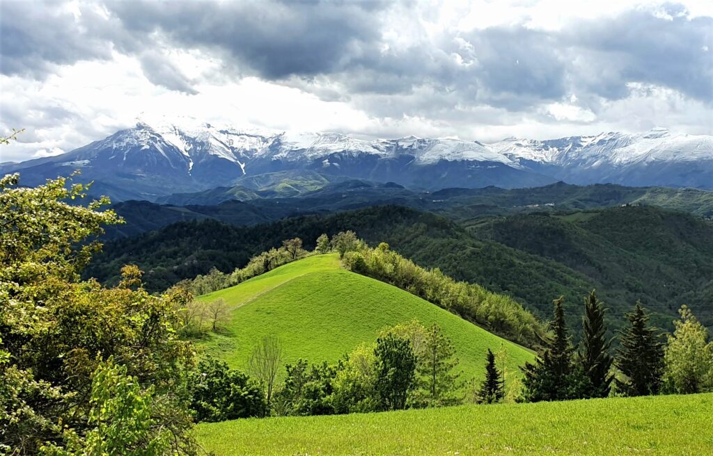
STAGE of great naturalistic impact that enters the protected territory of the Monti Sibillini National Park and travels along its wooded slopes to the medieval and spa town of Sarnano. The stories of the charcoal burners and shepherds are intertwined with those of St. Francis and his sodalists, just think of the convent of San Liberato where the famous Fioretti were written. It is recommended, should you decide to do the evocative variant of the Fiastrone Gorge, to bring sandals and towel for the ford and to be physically prepared to face a rough and treacherous route.
This is the STAGE to enter the territory protected by the Sibillini Mountains National Park: the barren profile of its mountains will be our backdrop until our arrival in Ascoli Piceno. Some of the rivers we cross along the way, such as the Fiastrone, the Tenna and the Aso originate right inside the Park. Rare floristic species that characterize it include the Apennine star, as many as 37 species of wild orchids, and the Bocconi hellebore. Mammals include the Italian wolf, the Apennine chamois and the sporadic presence of the Marsican bear. Also present are the golden eagle, Orsini’s viper and Marchesoni’s celebrated chirocephalus, a unique crustacean that lives only in Lake Pilate. From the Butterfly Garden we return to the crossroads, and here we leave the asphalt road to take the dirt road on the left that descends to the center of the village of Villa, which we cross on asphalt until we reach the church of Santa Maria Ausiliatrice. At the corner of the church we turn right slightly uphill on a paved surface of sanpietrini that soon becomes a dirt road. After 200 m, at the crossroads, we turn left, cross a small bridge and proceed on a slightly uphill dirt road following the Sibillini National Park signs to the crossroads for Grotta dei Frati and Gole del Fiastrone [5.1 – km 2.8]..
Here the main route continues straight following the dirt road with traces of old asphalt for 2.5 km. This is the shortest but least interesting route, which descends to the Fiastrone River valley and then climbs back up following switchbacks designed for cars to the cemetery of the village of Monastero [5.2 – 5.3 km].. It is recommended in times of flood, rain, bad weather and for those who do not feel up to the pitfalls of the path leading to the GROTTA DEI FRATI and the GOLE DEL FIASTRONE, a longer and more challenging variant described at the end of the STAGE.
From the cemetery, an asphalt road continues uphill for 300 m to the abbey of San Salvatore, an excellent place for a restorative stop with a fountain of fresh water. We continue uphill on asphalt until we cross SP 91 Pian di Pieca/Fiastra. We turn right onto the provincial road for 100 m and then, after another 100 m, we turn left to enter the small village of Monastero, which offers no services, but there is a good water source there. We cross it uphill and proceed straight ahead on the dirt road that we will not leave for 3.6 km to the summer residential village of San Liberato. Caution: along this stretch let’s always keep on the main road without considering any forks with minor roads, and above all let’s pay attention to the crossing of a landslide at km 8.9, which forces us to an aerial crossing without protection. 250 meters before the landslide, a small variant has been opened for this reason, allowing us to overcome this treacherous section resulting from the 2016 earthquake, pending restoration. From the residential village a descent on a wide breached road leads us after 900 m to the famous SANCTUARY OF SAN LIBERATO [5.3 – km 10.8].. A Franciscan place par excellence, in addition to its great spiritual tradition the monastery is famous for the quality of its public waters.
We resume the path on an uphill paved road, pass in front of one of the famous fountains, and after 500 m we arrive at the junction with SP 157. Following the Cfm signs we take a left downhill. After 100 m we find a Y-junction. Our path continues to the left on SP 157 but, for the more willing, we point out on the right the 1.7-km digression (plus as much on the way back) that leads to one of the most pleasant and evocative places of Franciscanism in the Marche: the hermitage of Soffiano whose ruins are located in a natural cave on the overhanging wall of Mount Ragnolo. Tradition has it that St. Francis stayed here on his journey to Ascoli. Back at the crossroads we continue as mentioned on SP 157. We continue to descend on asphalt for 1.6 km until we cross a path on the right that descends into the woods and saves us several hairpin bends of asphalt road [5.4 – km 13.2].. The passage crosses the ruins of an old village and comes out on the paved road that leads to the hamlet Terro di Sotto. We turn right and reach the small church. In front of the church, on our left, a downhill dirt road starts, which we take. We cross the bridge over the Rio Terro and then start climbing again without leaving the dirt road until we reach the junction with a paved road [5.5 – km 16.2].. At the crossroads, on the left, a downhill path threads its way through the vegetation, allowing us to cut several hairpin bends in the carriage road and join the asphalt road again in Contrada Campanotico, a hamlet of Sarnano. Here we follow the asphalt road to the right for 100 m to a crossroads that we pass proceeding straight on via Fonte Marta, where after 50 m we find a fresh water spring on the right. We continue straight ahead on the flat asphalt road meeting the first houses of the outskirts of SARNANO. We continue straight on via Fonte Marta, which now descends downhill between houses until it converges with via Alcide De Gasperi. Here we turn right, and then immediately left onto via Santa Rita. After 100 m we take another right downhill to bring us to Via Benedetto Costa. We turn left and after 100 m we are in Piazza della Libertà [5.6 – km 17.8].. From here we will move to reach the various reception facilities, and from here we will leave for the next STAGE.
Variant to the Grotta dei Frati and the Fiastrone Gorges [+ 3 km].
From the intersection [5.1 – km 2.8] you turn right and follow the level dirt road for 1 km to an opening set up for car parking. A tourist sign marks the entrance to the path that enters the forest proceeding on a false level. After 600 m we keep in mind the first fork in the path we encounter: left downhill to the Fiastrone Gorges, right uphill to the Grotta dei Frati. In case we want to give up visiting the Grotto we take the left path directly; otherwise from the junction to reach the Grotto we have another 500 m of nice trail on a false level. After 350 m we find another junction. We take the path to the left that remains level, and before long we will be at the GROTTA DEI FRATI, in one of the most scenic and spiritually significant places in the Apennines.
From here we return to the junction for the GOLE DEL FIASTRONE and, as mentioned, descend to the right on a steep path through the woods to the riverbed. Be careful: the last few meters of descent are definitely steep and it is worth helping ourselves to tree trunks. Now we have to wade. The water is freezing but it is preferable not to get your boots wet, so better plan to bring a towel and a pair of waterproof sandals or, in extremis, cross the river barefoot. The trail continues on the other side of the river. It immediately climbs steeply, plunging back into the thick vegetation. For fans of adventure and natural beauty, we point out here the possibility of overlooking the gorges that remain defiladed to the right from the trail. One must be very careful: the path to reach them no longer exists, because landslides and floods have obstructed their passage. For this reason the Sibillini National Park has decreed its temporary inaccessibility (for updates see www.sibillini.net). In case we want to explore it keep in mind that we will have to overcome fallen logs, unstable boulders and numerous fords, so waterproof grip shoes are necessary. But let’s get back to our uphill trail: a series of zig zags allows us to regain elevation shortly, we exit the dense forest, pass clearings and pastures and reach the small cemetery of Monastero [5.2], where we reconnect with the main trail.
STAGE 6 – Sarnano to Comunanza
Distance: 22.3 km.
Asphalt: 30%.
Dirt: 70%.
Walking time: 7.30 hours
Difficulty: medium
Maximum height: 656 MT.
Start: 530 mt.
Arrival: 450 mt.
DIislivel(+): 600 mt.
Height difference(-): 650 mt.
A foothill stage without great elevation gain skirting the peaks of the Sibillini Mountains along medieval paths, Roman roads such as the Salaria Gallica and historic bridges. It touches on Amandola, the center of the Monti Sibillini National Park, tiny villages and country parishes until it reaches the valley of the Aso River on which the industrious Comunanza lies.
From Piazza della Libertà we return to Via Benedetto Costa and walk along it for 350 m, then take a left downhill onto Via San Rocco, following the signs for the Cfm. After 200 m, at the level of the small church of San Rocco, we cross the paved road and take, in front of us, a dirt road that descends for 100 m and leads to via Aldo Moro. We cross it and continue straight on a shady downhill path that ends on a small asphalt road. We turn left and after 50 m, in front of a church, immediately to the right, we cross the bridge over the Tennacola River. The road becomes unpaved until after 150 m slightly uphill we reach a crossroads at a group of houses in the Morelli locality. We take the first paved road on the right threading between the houses and reach a small church located at a crossroads. We turn left keeping the small church on the right and pass the next crossroads continuing straight on the road that squeezes between two sheds. From here the path, at first on the flat, begins slightly to climb entering the countryside until we reach the hamlet of Grassetti [6.1 – km 2.4].. We pass the hamlet until we reach a crossroads. Here we leave the asphalt road and take the dirt road on the right.
After 50 m, at a bend, the Cfm sign tells us to continue to the right on a dirt path slightly uphill through the woods. This is the Via dei Mercatali, an ancient medieval trail frequented since ancient times by cattle merchants who came to Sarnano for the fairs. We proceed for 750 m to a fork and keep to the right path until it crosses another dirt road. We bend to the left slightly downhill and then begin an up and down through the woods. After 2 km, we go right at the intersection following the Cfm signs and travel 1.4 km slightly uphill. We are on the Salaria Gallica, the Roman road of the Ager Gallicus, traces of whose cobblestones are still evident. The ancient road ends at a trivium on a paved road. [6.2 – km 6.9].. We proceed straight ahead taking the road to the left, keeping the only present building of an old rural school on the left. We no longer leave the small asphalt road, which winds on a false level, first crossing a group of houses known as Casa di Carlo, then passing by the side of the Angolo di Paradiso organic dairy (where we highly recommend a stop to taste the company’s award-winning yogurt), and then passing a curious pet cemetery on the left. We continue for about 2 km more until we enter the outskirts of Amandola along Via Aldo Moro.
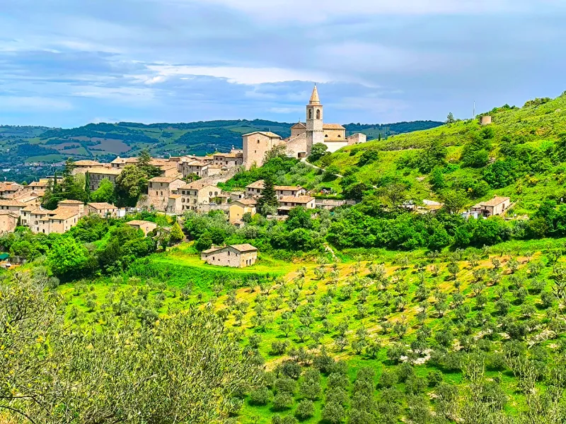
A steep descent brings us to the intersection with SP 237, which we cross, following the Cfm sign, to continue straight on the uphill asphalt in front of us in the direction of the Capuchin church and convent. After 600 m, at the gate of the convent, we bend onto a path to the left that runs alongside the wall of the religious building and descends until we reach the parking lot of a supermarket. We meet again the SP 237 coming from Sarnano and cross it, threading our way through the pedestrian area, clearly recognizable by the Cassa di Risparmio di Ascoli Piceno building on the right, thus arriving in the central square of AMANDOLA, Piazza Risorgimento [6.3 – km 11.2].. Here bars, restaurants, pizzerias and the municipal offices will be able to welcome pilgrims worthily for a stop and for stamping the credential.
At this point we descend to the right flanking the church of Sant’Agostino that faces the square; on our left we find the crossroads for Fermo, which we pass to bend immediately after the crossroads to the left steeply downhill along a cobblestone road between the houses that brings us to Piazzale Mercato. Here we take a left on downhill asphalt and follow Via Pignotto for 150 m until we cross, after a bend, a dirt road that bends sharply to the left. We follow it all the way until we reach the valley floor, at the bed of the Tenna River where, past an old FORTIFIED MILL, a beautiful hump-backed ROMANTIC pedestrian BRIDGE will lead us across the river. Past the bridge we ignore a dirt road on the left and continue on an uphill mule track on the right that comes out beside a shed in the Piandicontro industrial area of Amandola. We turn onto the paved road and continue straight, leaving the supermarket on the right. At the traffic circle we turn left onto Via Enrico Fermi and cross the whole industrial area for 300 m until we cross a dirt road on the right [6.4 – km 13], which we take. We pay attention: after 200 m, just before reaching a private fence, we bend left onto a downhill dirt road that soon becomes a path and runs alongside a thickly cultivated field with some beehives. We enter the vegetation and cross, as if suspended above, the Vetemastro stream, a tributary of the Tenna. We are passing over an ancient ROMAN BRIDGE, but the dense vegetation hides it: paying attention, however, before and after crossing, it is possible to catch a glimpse of the vault below. Caution is recommended when crossing it: the lack of safety railings and its aerial, thin line of passage make it treacherous. Beyond the bridge we continue steeply uphill on an earthen path, slippery in rain. We reach an agricultural field and skirt it on a path on the left uphill until we reach the church of Our Lady of Grace [6.5 – km 13.9], already visible from 200 m earlier. We continue uphill on dirt road for 650 m until we reach the hamlet of Salvi, where we find a water fountain that we leave on the right, continuing along the dirt road. Another 450 m of gentle ascent leads us to the hamlet of San Pietro in Castagna. The small church of the same name on the right, “hinged” following the 2016 earthquake, has notable bas-reliefs at the entrance portal.
At the church, just where the asphalt road begins, we leave the main road and turn left uphill on an earthen path well indicated by Cfm signs. Past a white house, we take the right mule track uphill at the fork, leaving a cultivated field on the right. After 600 m, at the height of the photovoltaic panels, we cross the hairpin bend of a paved road that we take to the right slightly downhill. Another 500 m and we find a crossroads: here we turn left uphill on a paved road. After 500 m at the first crossroads we keep right and continue for 2.4 km first on the flat and then downhill with some hairpin bends until we intersect the municipal road that leads from Comunanza to Smerillo and Montefalcone Appennino [6.6 – km 19.3].. We take it to the right downhill for 300 m and as soon as we turn a hairpin bend to the right, we take a small white road to the left that runs alongside the fence of a renovated country farmhouse and enters cultivated fields until it reconnects with a carriage road near a house that we leave on our left. We turn right slightly uphill and before long we are at the Villa Montegenco farmhouse: now the road goes back downhill on asphalt skirting a small fence wall. After 250 m at the crossroads we turn right and continue for 500 m until we cross farm sheds on the right and a large oak tree on the left. Below it starts a dirt road that descends threading its way through the woods: we take it and arrive on a scenic ridge.
Below our feet in the distance are the first houses of Comunanza. On leaving the woods, the ridge skirts a large cultivated field downhill. After about 50 m, at a picket of the Cammino, we turn right among the plants to reach the farmyard of an old abandoned farmhouse. Be careful: vegetation often closes the trail’s track forcing us to make our way through the shrubs. We continue downhill on its private road until we intersect SP 237. We turn left onto the asphalt and enter COMUNANZA. After about 300 m at the first traffic circle, at the height of a bar, we take the first exit on the right entering Via Dante, which we follow until we arrive in front of the town hall in Piazza IV Novembre [6.7 – km 22.3].
STAGE 7 – From Comunanza to Venarotta
Distance: 21.2 km.
Asphalt: 25%.
Dirt: 75%.
Walking time: 7 hours
DIifficulty: medium
Maximum height: 720 mt.
Start: 450 mt.
Arrival: 435 mt.
Height difference(+): 700 mt.
Height difference(-): 750 mt.
A STAGE with no steep climbs through the woods, crossing very little man-made territory and therefore devoid of services. Stock up well on water at the start since we will not find sources until Palmiano, the smallest municipality in the Piceno region. Suggestive views of the Sibillini Mountains, the Laga Mountains and the Gran Sasso as far as Venarotta, a Franciscan municipality devoted to welcoming pilgrims.
From the Comunanza Town Hall we take a right and enter the historic center, crossing the bridge over the Aso River and passing under the gallery of a small building to find ourselves in the small square of the church of St. Catherine of Alexandria. We turn right and enter the alley that joins Via XXIV Maggio. We keep to the right for 100 m until we reach the small church of St. Anne, on the left of which a dirt road starts uphill. We follow it all the way past two small groups of houses and then go into the woods to a junction of dirt roads [7.1 – km 2.2].. We take the one on the right, continuing to climb for 750 m up to the pass, where we find a crossroads: let us keep on the main one to the right and that shortly after bends steeply downhill to the left to descend on the other side until we come out on a dirt road at the height of some scattered houses known as Sette Carpini. We turn right and after just under 200 m we find a fork in the road. [7.2 – km 3.5].. We take the left road downhill, which proceeds for several kilometers with slight ups and downs in the woods until we come out into a clearing [7.3 – km 8] where on the left is a shepherd’s hut. Here we continue for 2.2 km on the main dirt road, passing through some cultivated fields and wooded areas until we come out onto a paved road, SP 65, which we take to the left proceeding uphill until we reach the village of Tavernelle [7.4 – km 10.4].. We begin to descend, continuing on SP 65, which we will not leave again until we reach Palmiano, ignoring the intersections with private roads; we cross a group of scattered houses until we come to a crossroads with road signs, where we continue on towards Palmiano. After 400 m we find another crossroads: the road on the left goes uphill, we take the one on the right that goes downhill and then continues keeping level until the intersection with the provincial road Palmiano/Venarotta [7.5 – km 14.6].. The small square of PALMIANO, the smallest municipality in the Piceno region, is only 100 m from the intersection continuing to the right. Instead we have to turn uphill to the left, but we still recommend a stop in the small town, where you can refuel with water, have a coffee and stamp your credential in the municipal offices. Back at the crossroads we continue uphill on asphalt for 200 m to the first hairpin bend, from the elbow of which a steep uphill path, known as the Amatucci coast, starts on the left, which in 700 m takes us to SP 93 Force/Venarotta. Without descending to the asphalt, we continue down steep slopes on the grassy ridge on our right for 200 m to the top of the hill, from which there is a majestic view. We walk the entire ridge for another 200 m to a clearing surrounded by fir trees. Caution: at the end of the clearing we have to turn sharply left downhill to intercept a dirt road that threads its way through the scrub and brings us back in sight of SP 93. We turn right at the edge of the road and in just over 100 m we find ourselves at the junction with the carriage road coming from Palmiano [7.6 – km 16.1]..
In front of us is a dirt road well indicated by the Cfm signs, which we follow slightly downhill. After 250 m we find a fork in the road, with a dirt road climbing to the left. We keep to the right, continuing to proceed on the dirt road on a false level for a couple of kilometers until we abandon it in favor of a path on the left hidden by vegetation [7.7 – km 18.7].. Care must be taken here: the Cfm signs indicate the trailhead, but the signs are often torn down, perhaps by hunters annoyed by the passage of pilgrims. The trail enters the forest steeply downhill for 500 m (be careful: in rain it may become treacherous) until the path becomes level after a wide left turn. Then it starts descending again until a sharp right hairpin bend, and after 50 m on the flat it bends sharply to the left with a downhill hairpin bend, leaving the main trail [7.8 – km 19.5]. We then proceed for 150 m slightly uphill until the forest thins out. Here the path becomes a straight downhill dirt road that ends in a clearing where some firewood is stacked and from which a dirt road starts on the left, which we take. After 100 m, at the junction, we turn right downhill onto a paved road that runs alongside the warehouses of the Venarotta artisanal area. We follow it until we reach a double junction after 450 m: we ignore the first one and turn right on the second one downhill until we cross the carriage road coming from Roccafluvione [7.9 – km 20.7].. Here we have two alternative solutions: if we want to stay overnight in the charming Ostello Spedale dei Ss. Francesco e Giacomo we will have to reach the hamlet of Castello following the variant indicated below, otherwise we continue until the conclusion of the STAGE, at the Church of the Cardinal in the center of Venarotta. From the crossroads we turn left on asphalt in the direction of the village; after less than 200 m at the crossroads we go left and at the next crossroads we turn right, to slip immediately afterwards on the left uphill through the alleys of the historic center and reach the Town Hall square. We continue up the sidewalks crossing stores and bars to the octagonal Church of the Cardinal, from which we will leave for the next STAGE [7.10 – km 21.2]..
STAGE 8 – Venarotta to Ascoli Piceno
Distance: 15.2 km.
Asphalt: 20% km.
Dirt: 80%.
Walking time: 5 hours
Difficulty: medium
Maximum height: 435 mt.
Start: 435 mt.
Arrival: 150 mt.
Height difference(+): 350 mt.
Height difference(-): 600 mt.
A rather short STAGE that reaches the center of Ascoli Piceno, the “white city of a hundred towers,” without ever passing through busy roads and following the development of the valley of the Chiaro stream, which we ford twice. Along the way we encounter the calanchi, the geological formations typical of this part of the territory, which can be admired in their best perspective by driving along the Venarotta – Montedinove link road/variant.
In Venarotta let’s get a good supply of water, since up to the gates of Ascoli Piceno we won’t find any public sources (although along the way we may encounter some private individuals happy to offer us water refreshment). If we have slept at the hostel we have to walk backwards along the road until the end of Via Castello, turn right for 200 m and then continue following the directions of the previous STAGE to reach the octagonal church of the Cardinal: here we take a right on asphalt following the road signs for Vallorano/Castellano/Cepparano. After 900 m, at a sharp bend, we leave the paved road and take a dirt road that continues straight ahead from our direction of travel. We go downhill through the trees for 300 m to a crossroads well marked by Cfm signs [8.1 – km 1.2].. We bend right on a downhill dirt road that soon becomes a path. We descend flush with sandstone slabs for 550 m and at the first fork continue on the path to the right until we reach, after another 550 m, a trijunction of dirt roads. We take the one on the left that climbs toward the small group of houses in contrada Salara and at the height of the first house we continue downhill on the right. In less than 300 m we reach the bed of the Chiaro stream, which we must ford using the stones at the water’s edge. Caution: in rainy periods the water level may rise so we would be forced to cross the stream barefoot or, preferably, with waterproof footwear.
Immediately after the ford we find a fork with vertical signs of the Cfm [8.2 – km 2.7]: turning left we go for Montedinove (Venarotta-Montedinove slip road/variant), while for Ascoli Piceno we proceed straight ahead on an earth road at first flat and then slightly uphill, going around the hill until we enter a dirt road at a hairpin bend. We proceed downhill on the right and continue in the direction of Venapiccola, ignoring all private roads.
After 1 km we pass in front of a small group of houses, and after another 400 m we meet a small country parish church on the left. The dirt road continues to climb until a crossroads, where the asphalt begins again, at the height of a small votive church [8.3 – km 5.5].. In front of us the outlines of the hamlets of Venapiccola and Venagrande. At the crossroads we take on the right the slope that leads to the top of the hill, in the small hamlet of Tirabotte. Here there is the house of Piero and Silvia, pilgrims and hospitalers, where, with prior phone notice (328-94.49.611), it is possible to find some refreshment and the stamp for the credential.
Having passed the last house of Tirabotte we encounter a fork in the road. We take the dirt road that descends to the right. After about 200 m at another fork we take the dirt road on the left as well indicated by the Cfm signs until we reach an isolated country house [8.4 – km 6.3]. Keeping the house on the right we take the small path that enters the forest straight ahead and descends to the valley floor to a wide grassy clearing. Here, too, we pay attention: the field is abandoned and grass often covers the tracks of the walkway. In any case we have to cross the entire clearing until we cross a perpendicular dirt road coming from the woods, which we take to the right toward the Chiaro creek, which soon faces us. Again we have to ford it to continue along the mule track beyond the riverbed.
After 300 m we encounter a dirt road. We take it to the left and proceed steeply uphill for 600 m until we intercept, near the hamlet of Villa Curti, SP 93, which leads from Venarotta to Ascoli Piceno. We take it to the right slightly uphill and after 150 m take the paved road on the left, uphill, with road signs to Gimigliano [8.5 – km 8.3].. We climb for 800 m to a hairpin bend from whose elbow a dirt road starts and heads toward the rocky cliff in front of us. We take the dirt road and after 100 m bend to the right on an uphill path that enters the trees and leads us to the top of the hill. Here we intercept the dirt road of the ridge into which we enter, turning left.
At first on a false level, the dirt road begins to descend gently to an isolated house where the asphalt begins again, which we follow for about 100 m and then, immediately after a right bend, we abandon to take a dirt road that bends sharply to the right, well indicated by the Cfm signs [8.6 – km 9.9].. The road always downhill passes in front of a small group of houses to arrive, after 2 km, at the confluence with a small paved road. Here we turn left and after 100 m we are at the votive church of Sant’Antonietto [8.7 – km 11.9].. We proceed straight on downhill asphalt to enter Via Santo Stefano da Montegranaro, by now on the outskirts of ASCOLI PICENO.
On the level we continue straight ahead, pass in front of the town cemetery and travel the entire street (now called San Serafino da Montegranaro), among the houses of the suburbs until we reach the 17th-century public washhouse, better known as the spring of Sant’Emidio. On the right is the Solestà Roman bridge over the Tronto River and the gateway of the same name to the city’s historic center [8.8 – km 14.2]. We cross the bridge and walk along Via Solestà and then turn left into the short Via Donne to reach Piazza Ventidio Basso: from here we take Via Cairoli and then, to the right, Via del Trivio, and reach the church of San Francesco overlooking the delightful Piazza del Popolo. We cross the square to then turn left into Via Cino del Duca and then right into Corso Trento e Trieste. At the end of the corso, Piazza Arringo opens up on the left, dominated by the façade of the Cathedral of Sant’Emidio, which houses the remains of the saint in its crypt [8.9 – km 15.2]..
SIGNAGE
Both horizontal and vertical signage is present
DANGERS
There is currently a major landslide, still passable with care and awaiting substantial safety work, between Monastero and san Liberato in STAGE No. 5 from Montalto di Cessapalombo to Sarnano. There are some easily surmountable fords along the way in the foothills area of the Marchigiano section.
ACCESSIBILITY
Just a few stretches of the first STAGE
ROAD BOTTOM.
25%
CREDENTIALS
The testimonium for those arriving in Assisi is issued by the Statio Peregrinorum of the Basilica of St. Francis and is the same for all Franciscan paths. For those arriving in Ascoli Piceno, on the other hand, it is issued by the Accreditation Point of the Cathedral of St. Emidio and for this reason precisely called Emidiana.
Assisi: Statio Peregrinorum of the Basilica of St. Francis, Piazza San Francesco 2, daily 10-12:30 a.m. and 3-6 p.m., tel. 075-81.90.01, info@sanfrancescoassisi.org. Ascoli Piceno: St. Emidio Cathedral Accreditation Point, Piazza Arringo, daily 9:30 a.m.-12:30 p.m. and 3-6 p.m.


THE GUIDE TO CAMMINO FRANCESCANO DELLA MARCA
The Cammino Francescano della Marca is an extraordinary route from Umbria through the entire Marche region on the steps of St. Francis. In the lands of the Fioretti, from Foligno to Muccia, from the convent of San Liberato to Amandola, among medieval villages and breathtaking scenery, such as the Menotre Falls and the Sibillini Mountains Park. A unique opportunity to meet territories rich in art and history, but also places and communities that have begun to live again after the recent earthquakes.
With all the useful information for walking the Camino in both directions: detailed maps, elevations, height differences, and for each STAGE a description of the route and possible variants. Also all the indications on where to sleep and what to visit; with insights into Franciscan places and realities to be discovered.

Journey diaries

The Cammino Francescano della Marca
With Cammini d’Italia’s free app, you can plan and walk The Cammino Francescano della Marca safely, being able to plan the stages in detail and walk the route thanks to the built-in GPS technology that supports your orientation during your adventure.
⠀Inside the app you will find many other paths present in Italy. Thanks to the georeferenced tracks of many routes you will be able to study the itinerary that suits you best and also download the GPX tracks of the individual STAGEs offline.
The app also includes a complete digital map of all the paths surveyed to date on our portal, giving you a wide range of choices among the many paths in the Belpaese.
⠀⠀
Cammini d’Italia is the perfect app for those who want to explore the beauty of Italy on foot, discovering hidden places surrounded by nature. Download it for free today and start planning your next adventure!
⠀
⠀
 ⠀⠀⠀
⠀⠀⠀