
Il Cammino della Pace
The Cammino della Pace It traverses three Italian regions (Abruzzo, Molise and Puglia), five provinces (L’Aquila, Pescara, Chieti, Campobasso and Foggia), three national parks (Gran Sasso, Maiella and Gargano) and various reserves and protected areas, tracing ancient Roman roads, transhumance sheep-tracks and pilgrimage routes, witnesses to the millennial History of this land.
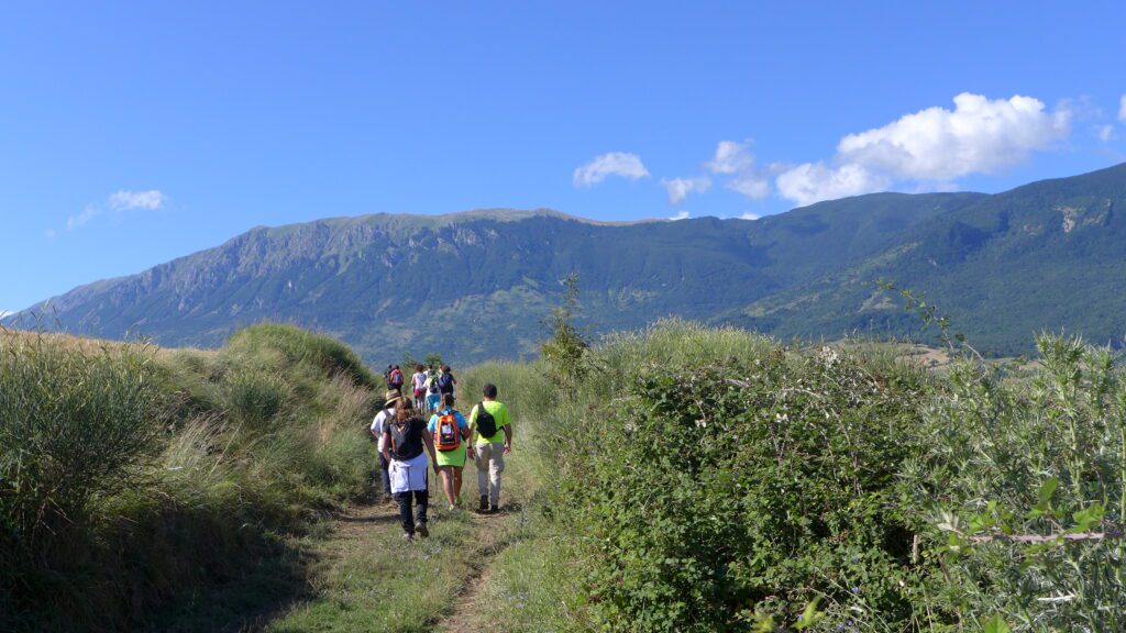
Along the more than 500 kilometers of the route, which takes its first steps from the basilica of Collemaggio in L'Aquila and, after 29 STAGES, reaches the underground sanctuary of St. Michael the Archangel in Monte Sant'Angelo, there is an inestimable wealth made up of abbeys, sanctuaries, hermitages, castles, extraordinary naturalistic and scenic suggestions and lively historic centers of great artistic and cultural tradition, which are also symbols of hospitality and welcome: a true “heritage of humanity,” which deserves to be preserved and handed down. A path open to people of all faiths and cultures.
HISTORY
The Cammino della Pace was born as a result of the positive outcome of a Guardiagrele student’s story during the sad night of the April 6, 2009 earthquake in L’Aquila. Saved because she was sleeping in an old house in the historic center, and not in her usual concrete home in the suburbs (which crumbled), the girl asked her father if she could go for a prayer of thanksgiving at the tomb of Padre Pio. This gave rise to the idea of a walking path that could unite L’Aquila with San Giovanni Rotondo, later extended to Monte Sant’Angelo, with the realization that that path, in fact, already existed: it was the millenary way of the transhumant shepherds along the sheep-tracks, the way of the abbots who went from one monastery to another, the way of the pilgrims who went to visit the many sanctuaries existing along the way, the way of the merchants, the way of the noble and the humble. The meeting with the Arbor Foundation, which works on projects related to intercultural and interfaith around the world, made this idea a reality.
WATER SOURCES.
Fountains are present in large numbers along the first 15 STAGES of the Cammino di Dante, while they are scarce or completely absent in the second half of the route; therefore, it is necessary to always leave with an abundant supply of water. The fountains present along the Way are indicated on the website at each STAGE.
STAGE
STAGE 1:
Departure: L’Aquila, basilica of Santa Maria di Collemaggio
Arrival: Villa Sant’Angelo (AQ)
Total km: 18.900
Uphill elevation gain: m 152
Downhill elevation gain: m 260
Maximum altitude: m 691 at the start
The first STAGE of IL CAMMINO DELLA PACE begins at the basilica of Collemaggio, in L’Aquila, one of the symbolic places of Abruzzo, where the remains of Pope Celestine V are kept. From here, the trail winds along the course of the Aterno River, passing through the hamlet of Monticchio and grazing the necropolis of Fossa. It then continues, still along the river, passing downstream from the town of Sant’Eusanio Forconese, to arrive in the village of Villa Sant’Angelo.
STAGE 2:
Departure: Villa Sant’Angelo (AQ)
Arrival: Prata d’Ansidonia (AQ)
Total km: 14.000
Uphill elevation gain: m 475
Downhill elevation gain: m 236
Maximum altitude: m 876
From Villa Sant’Angelo, the STAGE crosses the Aterno Valley to San Demetrio ne’ Vestini and, after an uphill stretch, joins the Tratturo Magno until it reaches the archaeological area of Peltuinum, an ancient Italic-Roman city. From here, it descends to the medieval church of San Paolo di Peltuinum and continues in the direction of the village of Prata d’Ansidonia, the conclusion of the STAGE.
STAGE 3
Departure: Prata d’Ansidonia (AQ)
Arrival: Caporciano (AQ)
Total km: 10.300
Uphill elevation gain: m 440
Downhill elevation gain: m 447
Maximum altitude: m 1068
From Prata d’Ansidonia, one skirts the fortified village of Castel Camponeschi, crosses the small hamlet of Tussio and climbs the mountainous hump on which the cave of St. Michael the Archangel and the castle of Bominaco are located; from the fortress, one descends to the Benedictine complex of Bominaco, formed by the church of Santa Maria Assunta and the oratory of San Pellegrino, and proceeds, still downhill, to the village of Caporciano.
Stage 4
Departure: Caporciano (AQ)
Arrival: Navelli (AQ)
Total km: 10.200
Uphill elevation gain: m 144
Downhill elevation gain: m 278
Maximum altitude: m 815
From Caporciano you descend to the plain below to the church of Santa Maria di Cintorelli, which marked the point where the Tratturo Magno forked giving rise to the Centurelle-Montesecco branch. Continue eastward on the plain and climb to the hamlet of Civitaretenga; from here, descend the other side again, flank the church of Santa Maria in Cerulis and reach Navelli, one of the most beautiful villages in Italy.
STAGE 5 (via Capestrano)
Departure: Navelli (AQ)
Arrival: Bussi sul Tirino (PE)
Total km: 20.300
Uphill elevation gain: m 352
Downhill elevation gain: m 693
Maximum altitude: m 683 (at the start)
From Navelli we take the deep valley that descends to the Capestrano plain, ascend slightly until we cross the historic center, home of St. John of Capestrano, and then again downhill to the banks of the Tirino River; continue along the river to the magnificent medieval church of San Pietro ad Oratorium and, still on the river bank, we reach Bussi sul Tirino, the conclusion of the STAGE.
STAGE 5 (via Collepietro)
Departure: Navelli (AQ)
Arrival: Bussi sul Tirino (PE)
Total km: 12.000
Uphill elevation gain: m 308
Downhill elevation gain: m 649
Maximum altitude: m 873
From Navelli, continue eastward flanking the small church of Madonna delle Grazie and climb toward the fortified village of Collepietro. Here, near the church of Our Lady of Buonconsiglio, you pick up the Centurelle-Montesecco Tratturo and follow it, with very steep downhill stretches, to the ruins of the church of Santa Maria di Cartignano, on the outskirts of Bussi sul Tirino, the end of the STAGE.
Stage 6
Departure: Bussi sul Tirino (PE)
Arrival: San Clemente a Casauria (PE)
Total km: 17.900
Uphill elevation gain: m 709
Downhill elevation gain: m 853
Maximum altitude: m 787
From Bussi sul Tirino, follow the Centurelle-Montesecco Tratturo, which steeply ascends to the Rocca Tagliata pass on the Gran Sasso mountain range; then descend to the Dogli district and then to Pescosansonesco, where the shrine and birthplace house of St. Nunzio Sulprizio are located. From Pescosansonesco, still downhill, pass through the center of Castiglione a Casauria and on to Torre de’ Passeri and the abbey of San Clemente a Casauria, one of the region’s most important medieval monuments, the end of the STAGE.
Stage 7
Departure: San Clemente a Casauria (PE)
Arrival: Salle (PE)
Total km: 15.900
Uphill elevation gain: m 775
Downhill elevation gain: m 498
Maximum altitude: m 527
From San Clemente, go through the village of Torre de’ Passeri and start climbing toward Santa Maria del Monte di Bolognano (entrance to Maiella National Park); from here, reach the quaint hamlet of Muséllaro, descend into the wild valley of the Orta River and climb up to the beautiful medieval church of St. Thomas Becket. From the church, you pass through the hamlet of St. Thomas and continue to the village of Salle.
STAGE 8
Departure: Salle (PE)
Arrival: Caramanico Terme (PE)
Total km: 10.200
Uphill elevation gain: m 460
Downhill elevation gain: m 315
Maximum altitude: m 622 (on arrival)
From Salle, where the remains of Blessed Robert of Salle, a disciple of Pietro del Morrone, rest, we climb to the abandoned village of Salle Vecchio and the castle, then descend to the Orta River and travel up its course to the foothills of Caramanico Terme, one of Italy’s most beautiful villages, which we cross in its entirety to arrive at the Park Visitor Center, the conclusion of the STAGE.
STAGE 9
Departure: Caramanico Terme (PE)
Arrival: Roccamorice (PE)
Total km: 14.400
Uphill elevation gain: m 738
Downhill elevation gain: m 830
Maximum altitude: m 819
From the Maiella Park Visitor Center, one proceeds downhill to the bottom of the Orfento Valley and ascends the watercourse until taking the path leading to the hamlet of Decontra. From here, you proceed to the Valle Giumentina plateau, cross it and, after the Paleolithic Ecomuseum, descend into the valley until you reach the striking rock church of San Bartolomeo de Legio. It then continues on a comfortable road to the town of Roccamorice.
STAGE 10
Departure: Roccamorice (PE)
Arrival: Serramonacesca (PE)
Total km: 17.200
Uphill elevation gain: m 825
Downhill elevation gain: m 1049
Maximum altitude: m 902
From Roccamorice, you walk uphill on asphalt for the first time and then downhill, in the bottom of the Sant’Angelo valley, on the path to Grotta Sant’Angelo, from where you climb back up to SP 65; past Fonte Pirella you enter the Maiella pastures, dotted with numerous dry stone huts. One begins the descent of the mountain slope and enters the woods, where shortly afterwards one encounters the rock hermitage of Sant’Onofrio. From here you descend to the village of Serramonacesca.
STAGE 11
Departure: Serramonacesca (PE)
Arrival: Roccamontepiano (CH)
Total km: 10.000
Uphill elevation gain: m 621
Downhill elevation gain: m 458
Maximum altitude: m 640
From Serramonacesca we climb to the splendid monastic church of San Liberatore a Maiella, continue along the verdant valley of the Alento River and ascend to the ruins of the Polegro Tower; from here, still uphill, we reach the Montepiano plateau, from where, with a last downhill stretch, we reach the convent of San Francesco Caracciolo and arrive in the town of Roccamontepiano, the conclusion of the STAGE.
STAGE 12
Departure: Roccamontepiano (CH)
Arrival: Guardiagrele (CH)
Total km: 17.800
Uphill elevation gain: m 800
Downhill elevation gain: m 690
Maximum altitude: m 579 (on arrival)
From Roccamontepiano one proceeds to the ruins in the convent of San Pietro, then up to the contrada Sant’Angelo and, in a hilly, gully environment, proceed downstream to the village of Pretoro and then to the foothills of the Maiella to the Grotta del Colle and the town of Rapino. Past the shrine of the Madonna di Carpineto, you reach the contrada Santa Lucia, on the tratturo, and finally Guardiagrele, one of the most beautiful villages in Italy.
MOUNTAIN VARIANT
STAGE 9 of variant
Departure: Caramanico Terme (PE)
Arrival: Santo Spirito di Maiella (PE)
Total km: 14.400
Uphill elevation gain: m 1150
Downhill elevation gain: m 614
Maximum altitude: m 1162 (on arrival)
From the Maiella Park Visitor Center, proceed downhill to the bottom of the Orfento Valley and up the stream to take the path leading to the hamlet of Decontra (section coinciding with the initial stretch of the 9th STAGE). From here we proceed uphill on a stretch first in pasture and then in the thick beech forest, until we reach the rock abbey of Santo Spirito di Maiella, the end of the STAGE.
STAGE 10 of variant
Departure: Santo Spirito di Maiella (PE)
Arrival: Refuge B. Di Marco (PE)
Total km: 10.000
Uphill elevation gain: m 1173
Downhill elevation gain: m 585
Maximum altitude: m 1747 (on arrival)
From the abbey of Santo Spirito di Maiella first descend a short distance to the watercourse, then continue on a challenging climb in the woods to Piana Grande and, on a downhill path still in the woods, arrive at the spectacular rock hermitage of San Giovanni all’Orfento. From here, climb up to the exit from the woods and continue on an uncovered path through the pastures to the “M. Di Marco” Refuge, where you can stay overnight (you need to get a key from the Caramanico Visitor Center).
STAGE 11 of variant
Departure: Refuge B. Di Marco (PE)
Arrival: Guardiagrele (CH)
Total km: 16.400
Uphill elevation gain: m 566
Downhill elevation gain: m 1742
Maximum altitude: m 1840
From the Rifugio “Di Marco” you cross the Prato della Maiella (up to 1840 m asl) and reach the SP, from where you begin the descent into the Guardiagrele valley, passing through Fonte Carlese, il Campanaro and Valle delle Monache. From here, still in the beech forest, one enters the valley as far as the Cascata San Giovanni waterfall and reaches the locality of Bocca di Valle, where the Andrea Bafile shrine is located (alternatively, from Valle delle Monache it is possible to reach Piana delle Mele and arrive equally at Bocca di Valle). Passing through the Comino district and skirting the church of San Donato, you reach Guardiagrele (leave the key to the hut at the Maiella Park office on Occidentale Street).
Stage 13
Departure: Guardiagrele (CH)
Arrival: Orsogna (CH)
Total km: 14.000
Uphill elevation gain: m 406
Downhill elevation gain: m 549
Maximum altitude: m 579 (at the start)
From Guardiagrele, where the remains of St. Nicola Greco rest, a steep descent leads to the locality of Piana San Bartolomeo and then up to Piano Venna, from where on a comfortable up-and-down road one arrives first at the sanctuary of the Madonna della Libera di Filetto and then at the Franciscan convent of the Annunziata, at Feuduccio. From the convent you cross a short section of the Annunziata Park and arrive at the town of Orsogna.
Stage 14
Departure: Orsogna (CH)
Arrival: Lanciano (CH)
Total km: 11.500
Uphill elevation gain: m 423
Downhill elevation gain: m 584
Maximum altitude: m 429 (at the start)
From Orsogna, a town crossed by the Tratturo Centurelle Montesecco, you descend to the Moro stream and continue along the valley floor, on dirt and asphalt stretches, until you reach the small church of Santa Maria dei Mesi; from here, continue in the direction of Lanciano and enter the town at the medieval Torri Montanare. You skirt the stunning Gothic church of Santa Maria Maggiore and arrive in the center at the Shrine of the Eucharistic Miracle.
STAGE 15
Departure: Lanciano (CH)
Arrival: San Giovanni in Venere (CH)
Total km: 13.400
Uphill elevation gain: m 345
Downhill elevation gain: m 508
Maximum altitude: m 283
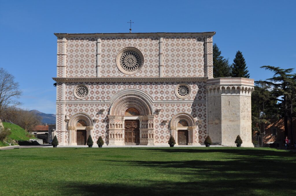
From Lanciano, past the racetrack, on proceeds first on a bike path, then up and down in a hilly environment you pass the medieval church of San Silvestro and reach the heart of Rocca San Giovanni, one of the most beautiful villages in Italy. From the village, still in an agricultural environment, you pass the town of Fossacesia and end the STAGE at the grand Benedictine abbey of San Giovanni in Venere.
STAGE 16
Departure: San Giovanni in Venere (CH)
Arrival: Trabocco Le Morge (CH)
Total km: 13.100
Uphill elevation gain: m 365
Downhill elevation gain: m 470
Maximum altitude: m 131
From San Giovanni in Venere you quickly descend to the Adriatic coast and, walking a long stretch, cross the Sangro River and enter the reserve of the “Lecceta di Torino di Sangro”; still going uphill, through the woods, you climb the promontory to the Sangro River War Cemetery, a war cemetery of the Allied forces. Back in the lecceta, you walk through it until you return to the coast, where the STAGE ends at Trabocco Le Morge.
STAGE 17
Departure: Trabocco Le Morge (CH)
Arrival: Casalbordino (CH)
Total km: 13.600
Uphill elevation gain: m 368
Downhill elevation gain: m 179
Maximum altitude: m 202 (on arrival)
From Trabocco Le Morge, we ride along a stretch of coastline on a bicycle path to the Lido di Casalbordino, then climb the hillside full of vineyards and reach the famous Sanctuary of the Madonna dei Miracoli; from here, we shortly reach the town of Casalbordino, the conclusion of the STAGE.
STAGE 18
Departure: Casalbordino (CH)
Arrival: Monteodorisio (CH)
Total km: 15.000
Uphill elevation gain: m 465
Downhill elevation gain: m 353
Maximum altitude: m 314 (on arrival)
From the town of Casalbordino, we proceed eastward, pass just downstream of the small town of Pollutri and continue until we cross the Sinello River; from the river, the road proceeds steadily uphill, not steep but steady, flanking the small country chapel of San Bernardino, until we arrive on a paved road in the center of Monteodorisio, where at the Marian shrine of Madonna delle Grazie the STAGE ends.
STAGE 19
Departure: Monteodorisio (CH)
Arrival: Lentella (CH)
Total km: 14.800
Uphill elevation gain: m 570
Downhill elevation gain: m 498
Maximum altitude: m 386 (on arrival)
From Monteodorisio we march south toward the small town of Cupello, beyond which we proceed in the direction of the Treste River, with a continuously up-and-down route in a hilly environment, until we reach, on a very steep uphill stretch, the characteristic village of Lentella, dominated by the parish church of Santa Maria Assunta.
STAGE 20
Departure: Lentella (CH)
Arrival: Montenero di Bisaccia (CB)
Total km: 12.800
Uphill elevation gain: m 333
Downhill elevation gain: m 448
Maximum altitude: m 388 (at the start)
From Lentella one faces the long descent in the direction of the Trigno River, which marks the border between Abruzzo and Molise; past the ford known as “Pietra Fracica,” one begins the ascent on the opposite side, with even challenging stretches, to the center of Montenero di Bisaccia, where the STAGE ends.
STAGE 21
Departure: Montenero di Bisaccia (CB)
Arrival: Guglionesi (CB)
Total km: 15.900
Uphill elevation gain: m 549
Downhill elevation gain: m 445
Maximum altitude: m 375 (on arrival)
Just outside the built-up area is the Marian shrine of the Madonna di Bisaccia, beyond which, with a short detour, one can visit the Cave of the Madonna della Bisaccia, which opens in a rocky block along the Tratturo Centurelle Montesecco. Here the trattural path is very evident and you can follow it to the next valley, from where the last uphill stretch that leads to Guglionesi begins.
STAGE 22
Departure: Guglionesi (CB)
Arrival: Madonna Grande (CB)
Total km: 17.900
Uphill elevation gain: m 337
Downhill elevation gain: m 630
Maximum altitude: m 375 (at the start)
Still in an intensely cultivated hilly environment, the Cammino descends from Guglionesi to the Biferno River and, continuing to follow the Tratturo, which is always very evident, proceeds eastward halfway between Portocannone and San Martino in Pensilis, until it reaches Nuova Cliternia, a hamlet of Campomarino, where the shrine of the Madonna Grande is located.
Stage 23
Departure: Madonna Grande (CB)
Arrival: Serracapriola (FG)
Total km: 19.100
Uphill elevation gain: m 458
Downhill elevation gain: m 270
Maximum altitude: m 271 (on arrival)
From Madonna Grande you return to the Tratturo Magno and follow it for a long stretch to the Saccione stream, which marks the border between Molise and Puglia; here, at the foot of the Montesecco, there was a large trattural rest and it was the place where the Tratturo Magno and the Tratturo Centurelle Montesecco met. It proceeds in ups and downs, with a final stretch of challenging ascent leading to the village of Serracapriola.
STAGE 24
Departure: Serracapriola (FG)
Arrival: San Paolo di Civitate (FG)
Total km: 15.500
Uphill elevation gain: m 287
Downhill elevation gain: m 368
Maximum altitude: m 269 (at the start)
From Serracapriola we descend to the Fortore River, on whose right bank stood the Taverna di Civitate, a customs station where tolls were paid for crossing the river; from the Taverna, a not excessively long climb leads to the plateau on which San Paolo di Civitate stands, the end of the STAGE.
STAGE 25 (via Apricena)
Departure: San Paolo di Civitate (FG)
Arrival: Apricena (FG)
Total km: 18.400
Uphill elevation gain: m 122
Downhill elevation gain: m 230
Maximum altitude: m 189 (at the start)
Leaving San Paolo di Civitate, pass the trattural chapel of Madonna di Belmonte and, at the crossroads, take the left-hand road, which crosses wide flat cultivated expanses and leads into the town of Apricena, where the STAGE ends.
STAGE 26 (via Apricena)
Departure: Apricena (FG)
Arrival: Santa Maria di Stignano (FG)
Total km: 16.200
Uphill elevation gain: m 324
Downhill elevation gain: m 131
Maximum altitude: m 296
From Apricena, on flat country roads, we arrive at the San Marco in Lamis station, from where we turn onto Via Francigena and begin to climb up the side of the Gargano promontory until we reach the convent-sanctuary of Santa Maria di Stignano, the conclusion of the STAGE.
STAGE 25 (via San Severo)
Departure: San Paolo di Civitate (FG)
Arrival: San Severo (FG)
Total km: 13.500
Uphill elevation gain: m 98
Downhill elevation gain: m 196
Maximum altitude: m 189 (at the start)
Leaving San Paolo di Civitate, one passes the trattural chapel of Madonna di Belmonte and, at the crossroads, takes the right-hand road, which crosses wide flat cultivated expanses and arrives in the town of San Severo, where the STAGE ends.
STAGE 26 (via San Severo)
Departure: San Severo (FG)
Arrival: Santa Maria di Stignano (FG)
Total km: 19.800
Uphill elevation gain: m 320
Downhill elevation gain: m 143
Maximum altitude: m 189 (at the start)
From San Severo on the plains and for a long stretch on a now disused railroad, proceed in the direction of the San Marco in Lamis station and, from there, on Via Francigena, begin to climb the side of the Gargano promontory, where the convent-sanctuary of Santa Maria di Stignano, the conclusion of the STAGE, is located.
Stage 27
Departure: Santa Maria di Stignano (FG)
Arrival: San Matteo (FG)
Total km: 11.900
Uphill elevation gain: m 740
Downhill elevation gain: m 298
Maximum altitude: m 883
From Santa Maria di Stignano, with a fairly steep and challenging initial section, climb the Gargano promontory, passing through an area known for the presence of numerous hermitages and rocky places of worship, and then descend further east to the convent of St. Matthew the Apostle, overlooking the village of San Marco in Lamis.
Stage 28
Departure: St. Matthew (FG)
Arrival: San Giovanni Rotondo (FG)
Total km: 10.000
Uphill elevation gain: m 464
Downhill elevation gain: m 597
Maximum altitude: m 938
From St. Matthew’s Convent we again climb the Gargano, traveling through widely scenic stretches in the typical limestone environment of the promontory, until we descend again to San Giovanni Rotondo, where the convents and shrines of Father Peter of Pietrelcina are located and where the Saint’s body is venerated.
Stage 29
Departure: San Giovanni Rotondo (FG)
Arrival: Monte Sant’Angelo /FG)
Total km: 22.400
Uphill elevation gain: m 690
Downhill elevation gain: m 452
Maximum altitude: m 861
From San Giovanni Rotondo, one travels eastward along a flat stretch, then faces the long ascent, first in dense forest and then out in the open, in a pasture and bushy environment, to rise again to the top of the Gargano and reach the wonderful village of Monte Sant’Angelo, where the grotto of the apparition of Archangel Michael, a UNESCO-protected site, marks the conclusion of IL CAMMINO DELLA PACE.
SERVICES PRESENT STAGE BY STAGE
Bars, supermarkets and pharmacies can be found in all towns and cities that are the site of a STAGE or crossed by the Cammino della PACE. Even in smaller towns it is always possible to find at least one grocery store.
Services are absent along the mountain variant STAGES on the Maiella, so those who are intent on traveling them uninterrupted will need to equip themselves with everything they need upon departure from Caramanico Terme.
SIGNAGE
The Il Cammino della Pace is entirely marked with specific red-white painted signage, which is the official signage used by CAI and in the parks. The adhesive signage, applied to metal posts and guard rails, bears the logo of the Walk; the direction of travel of the two pilgrims in the logo indicates the direction of travel of the STAGE. There are also plaques affixed to existing wooden supports with red directional arrows. However, it is recommended to set off having GPX tracks with you, which are free to download from www.ilcaminodellapace.it. On sections within the Gran Sasso, Maiella and Gargano National Park, in reserves and where the Path overlaps with other existing paths (Path of the Spirit, Via Francigena), the signage will be the official one of the entities or associations that manage them, with the integration of plaques.
DANGERS
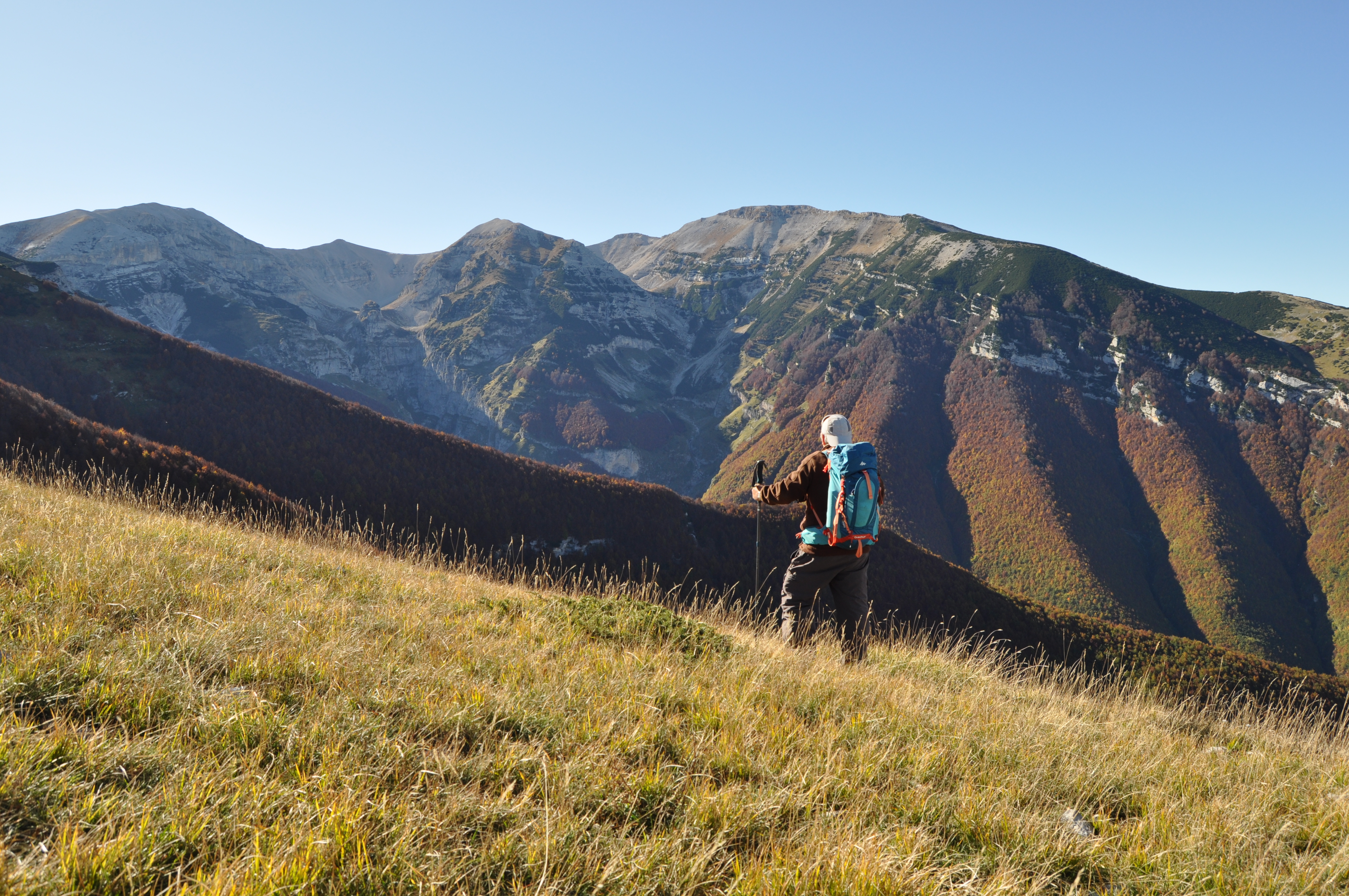
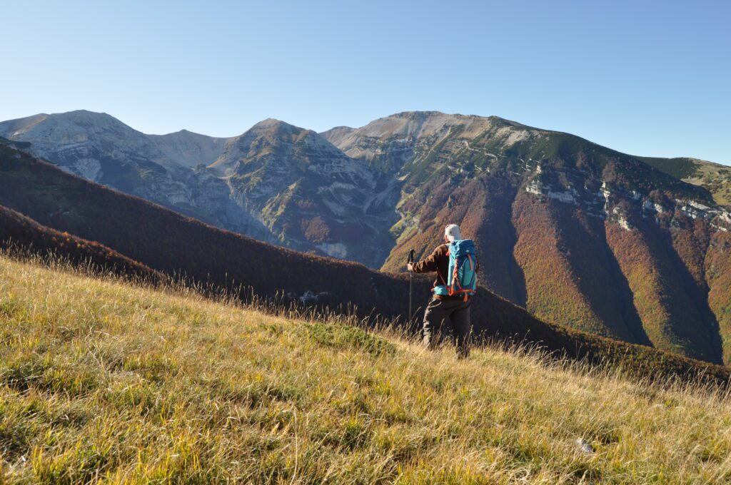
IIL CAMMINO DELLA PACE presents no particular risks and is suitable for everyone. It is entirely signposted, but one should not expect to find signage at every intersection or after every bend. The maintenance and upkeep of the signage is the responsibility of the Association’s volunteers, who often have to restore previously marked sections because stickers or plaques have been removed or damaged. GPX tracks, maps on the website and in the guidebook, however, make it easy to follow the route. The Walk tried, as far as possible, to follow the sheep-tracks and ancient routes on paths, dirt tracks and cart-tracks, but where this was not possible, we had to resort to paved roads, which, however, only in very rare cases have considerable traffic. Caution is always recommended, however. All along the route, and not only in the areas within the parks, encounters with wildlife are possible, which thanks to natural reforestation, especially in Abruzzo, has made it all the way to the coasts. Keeping calm, staying put and avoiding aggressive attitudes, is the best way to enjoy the encounter safely. Variant STAGES 9, 10 and 11 traverse one of the wildest and most spectacular areas of the Maiella Park; you will travel along trails that are strenuous but extraordinarily scenic, along which there is the possibility of running into the vagaries of the weather, encountering wildlife and grazing flocks. Along STAGE 11v there are a couple of short “aerial” passages without protection to be approached with caution, as well as the access to the hermitage of San Giovanni all’Orfento.
TENT WALK
In principle, IL CAMMINO DELLA PACE can also be traveled in tents, but it is necessary to contact the STAGE contact persons (contact information is on the website) for information on where to camp.
ACCESSIBILITY
The route is extremely varied, alternating between rough sections and sections that are more easily traversed. STAGES that are fully or partially passable for people with disabilities will be indicated on the Trail website.
ROAD BOTTOM.
38% paved roads (state, county, municipal)
62% breached roads, dirt roads, trails
CREDENTIAL
The Credential is issued by the association “Il Cammino della Pace” to all those who intend to walk the Path and who undertake to maintain a behavior that respects the cultural, natural and anthropological assets present, as well as the human communities that live along it. The pilgrim is the primary custodian of the riches he encounters and is personally called upon to protect and defend them. The credential is prepared exclusively to be used for the Il Cammino della Pace, although some of the STAGES are also common to other paths, routes and trails and can be requested directly on the website of the Walk.
The Credential provides access to accommodations and refreshment facilities located along the Camino at subsidized rates and according to criteria and modalities that must be accepted and respected; it can be requested via email or through the appropriate function on the website and is issued against a donation or offering for reimbursement (as specified on the website), to meet the costs of sending the Credential itself and the Testimonium.


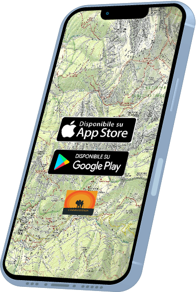
DISCOVER THE STAGES
With Cammini d’Italia’s free app, you can plan and walk the Il Cammino della PACE safely, being able to plan the stages in detail and walk the route thanks to the built-in GPS technology that supports your orientation during your adventure.
⠀Inside the app you will find many other paths present in Italy. Thanks to the georeferenced tracks of many routes you will be able to study the itinerary that suits you best and also download the GPX tracks of the individual STAGEs offline.
The app also includes a complete digital map of all the paths surveyed to date on our portal, giving you a wide range of choices among the many paths in the Belpaese.
⠀⠀
Cammini d’Italia is the perfect app for those who want to explore the beauty of Italy on foot, discovering hidden places surrounded by nature. Download it for free today and start planning your next adventure!
⠀
⠀
 ⠀⠀⠀
⠀⠀⠀