
La Via del Fantini
A 50-km walk in the hills of Bologna: from the Via Emilia, all along the Zena Valley between history and nature in the footsteps of Luigi Fantini.
La Via del Fantini is a 50-kilometer hiking trail that climbs from the rolling hills of San Lazzaro di Savena to San Benedetto del Querceto. The route follows the Valley of the Zena Stream passing through nature parks and ancient villages on spectacular trails. Caves, museums and archaeological sites to be discovered along Luigi Fantini's steps and discoveries. An “open and widespread museum” that the Parco Museale della Val di Zena association has been preserving and protecting for more than a decade. An area rich in nature and beauty just a stone's throw from Bologna that despite its fragility is ready to be discovered.
HISTORY
LA VIA DEL FANTINI was born from the need to connect the places that the association Parco Museale della Val di Zena protects and wants to make freely visitable. The project was born in 2018 thanks to obtaining initial funding from the Fondazione Carisbo, the Unione dei Comuni Savena Idice and the Municipality of San Lazzaro di Savena. Close collaboration with the Club Alpino Italiano of Bologna made it possible to create a well-marked path that is of vital importance to the hiking network in the hills of Bologna. Numerous entities were involved along the path: the “Luigi Donini” Museum of Prehistory, the Parco dei Gessi Bolognesi e Calanchi dell’Abbadessa (Ente Parchi Emilia Orientale), the Luigi Fantini Botroids Museum, the Monte Bibele Archaeological-Naturalistic Area and the “L. Fantini” Civic Archaeological Museum. The trail was tabulated and marked in 2019, and the inauguration of the path took place in July 2020. In December 2021 after participatory fundraising, the website was created, and after the pandemic period, the promotion and organization of guided nature hikes, cultural, artistic, theatrical and musical events along the path began. Between 2023 and 2024, the area suffered 3 disastrous floods and the trail was severely compromised, but thanks to CAI and donations from local businesses, volunteers have always managed to get the trail back on track and allow new hikers to visit our beautiful and fragile Zena Valley.
Who was Luigi Fantini?
The trail is dedicated to a key figure in the area. Luigi Fantini (1895-1978) was a self-taught explorer and researcher, a pioneer in speleology and the development of the territory of the early Bolognese Apennines. Born near the Farneto Cave, he soon became passionate about nature and prehistory. In 1932 he founded the Bolognese Speleological Group, discovering caves such as Spipola. His research contributed to the birth of the Parco dei Gessi Bolognesi, now a UNESCO World Heritage Site. He collected geological and archaeological finds now on display in Bolognese museums, three of which bear his name. A keen photographer, he documented the rural architecture of the Bolognese Apennines: his work “Antichi Edifici della Montagna Bolognese” is still a reference today. Despite his elementary education, he was esteemed by academics and scientific institutions. He rests in the cemetery of Monte delle Formiche, in the heart of his beloved mountains. His legacy lives on in the landscapes, trails and museums of the Zena Valley.
WATER
Water sources are present at the many small towns crossed by the trail. The chalky, clayey terrain is not conducive to the formation of natural springs, and travel on the trail is strongly discouraged during the driest and hottest part of the summer.
Sources on the first STAGE:
- Cedar Park, St. Lazarus of S. (coordinates: 44.47219, 11.39895)
- Resistance Park, St. Lazarus of S. (coordinates: 44.46849, 11.40045)
- Public Garden, Ponticella (coordinates: 44.45844, 11.38097)
- La Palazza, Ponticella (coordinates: 44.44815, 11.37827)
- Fantini House Park, Farneto (coordinates: 44.43161, 11.40193)
Sources for the second stage:
- Fantini House Park, Farneto (coordinates: 44.43161, 11.40193)
- Oak Park, Botteghino di Zocca (coordinates: 44.39901, 11.39359)
- Az. agr. Salvatore Cottu, Gorgognano (coordinates: 44.355, 11.37389)
Sources on the third STAGE:
- Az. agr. Salvatore Cottu, Gorgognano (coordinates: 44.355, 11.37389)
- Zena (coordinates: 44.34436, 11.36901)
- Cà di Pippo (coordinates: 44.33192, 11.38614)
- Canovetta, Cà di Pippo (coordinates: 44.32677, 11.38139 )
- Mount Ant Sanctuary (coordinates: 44.3192, 11.38597)
Sources on the fourth STAGE:
- Mount Ant Sanctuary (coordinates: 44.3192, 11.38597)
- Mount Bibele Service Center (coordinates: 44.27557, 11.37479)
- Peace Square, Quinzano (coordinates: 44.26106, 11.36662)
San Benedetto del Querceto (coordinates: 44.25441, 11.3755)
SERVICES
STAGE 1:
San Lazzaro: railway station, bus stops (15, 19, 94, 101, 916, 918), supermarkets, pharmacies, medical clinic, restaurants, cafés, and various accommodations.
Ponticella: pharmacy, grocery stores, restaurants, cafés, and various accommodations.
Farneto: restaurants, cafés, and various accommodations.
STAGE 2:
Farneto: restaurants, bars and various accommodations
Zocca box office: restaurants, bars, various lodgings and pharmaceutical dispensary open only on some days, bus stop 126 (not on Sundays)
Gorgognano: restaurants and various accommodations
STAGE 3:
Zena: restaurant, bar, various accommodations
Ca’ di Pippo: guesthouse (Karol House)
(Possibly an hour’s walk away is also Cà di Bazzone or Monterenzio where you can find: bus stops 916 918, supermarkets, pharmacies, medical clinic, restaurants, bars and various accommodations).
Stage 4:
Mount Bibele: service center and bar, various accommodations
Quinzano: restaurants, various accommodations, grocery store and 918 bus stop (not on Sundays)
San Benedetto del Querceto: restaurant, grocery store, and bus stops 918 and 916
SIGNAGE
LA VIA DEL FANTINI is fully marked with official CAI trail signs and can be easily walked by following the red and white signs and the Via del Fantini logo. Along the way a dozen lecterns provide the hiker with information on natural and historical points of interest. There are also five panels providing hiking and cartographic information.
ROAD BOTTOM.
The trail is almost entirely on path, very quiet dirt or paved roads. In total, the stretches of busy road along the entire route amount to 4.2 km.
- Tappa 1: 500 m
- Tappa 2: 200 m
- Tappa 3: 2 km
- Tappa 4: 1,5 km
ROUTE IN TWO OR THREE DAYS
ROUTE IN TWO OR THREE DAYS
3-DAY ROUTE:
The trail was originally designed as four short half-day stages, allowing hikers to visit museums and points of interest along the route.
For those with 3 days to spare and a good workout, 3 days can be a great way to divide the nearly 50 km and 2000 meters of elevation gain of the route.
A long weekend, a bridge, or three days in spring are perfect opportunities to explore the nature of the Valley and discover many stories about Luigi Fantini and his discoveries.
DAY 1 of 3:
San Lazzaro di Savena to Botteghino di Zocca.
TECHNICAL DATA.
Donini Museum, San Lazzaro di Savena (67 m) – Botteghino di Zocca (120 m)
-LEVEL: +750 / -700
-LENGTH: 17 km
-DIFFICULTY: E (hiking)
-TIME: 6 h
DAY 2 of 3:
From Botteghino di Zocca to Cà di Pippo
TECHNICAL DATA.
Botteghino di Zocca (120 m) – Cà di Pippo (400 m)
-LEVEL: +650 / – 400
-LENGTH: 12 km
-DIFFICULTY: E (hiking)
-TIME: 5 h
GIORNO 3 di 3:
From Cà di Pippo to S. Benedetto del Querceto
TECHNICAL DATA.
Cà di Pippo (400 m) – San Benedetto del Querceto (350 m)
-LEVEL: +750 / – 850
-LENGTH: 12 km
-DIFFICULTY: E (hiking)
-TIME: 6 h
2-DAY ITINERARY:
La Via del Fantini is a cultural route, full of proposals, museums, caves to visit, farms or stories to listen to. Those who already know the area, those who have little time and, above all, excellent training can decide to cover the entire route in just two days. So many kilometers and so much climbing, at the expense of cultural stops and guided tours: a perfect solution for those who travel light or are used to long Apennine walks or backpacking crossings over the Alps.
DAY 1 of 2:
San Lazzaro di Savena to Zena
TECHNICAL DATA.
Donini Museum, San Lazzaro di Savena (67 m) – Zena (200 m)
-LEVEL: +1000 / -900
-LENGTH: 27 km
-DIFFICULTY: E (hiking)
-TIME: 8 hrs.
GIORNO 2 di 2:
Zena to San Benedetto del Querceto
TECHNICAL DATA.
Zena (200 m) – San Benedetto del Querceto (350 m)
-LEVEL: +1000 / -900
-LENGTH: 16 km
-DIFFICULTY: E (hiking)
-TIME: 8 hrs.
SINGLE DAY TRAILS: LOOP TRAILS
If you only have one day to dedicate to our trail, you can choose one of our circular routes; you’ll find them in the dedicated section on our website.
IN TENT
There are no special rules for bivouacking in tents. Many accommodations along the route allow hikers to pitch a tent and offer additional services.
(by the managing body of the path)
CREDENTIAL
Credentials are not yet available
CONTACTS
Site: https://viadelfantini.it/#
Mail:
- info@parcomusealedellavaldizena.it
- escursioni@viadelfantini.it
Phone contact:
335 7092063 (Marco d’Agostino)
STAGE 01
STAGE 01: From Donini Museum to Fantini House.
Departure: Donini Museum
Arrival: Fantini House
Distance: 10 km
Height difference: +450m / – 450m
ACCESS
– San Lazzaro di Savena: train from San Lazzaro train station, SS 09 (Via Emilia), regular buses (15, 19, 94, 101, 916, 918)
-Farneto: SP 36 (Via Zena), regular bus service (126 not on Sundays)
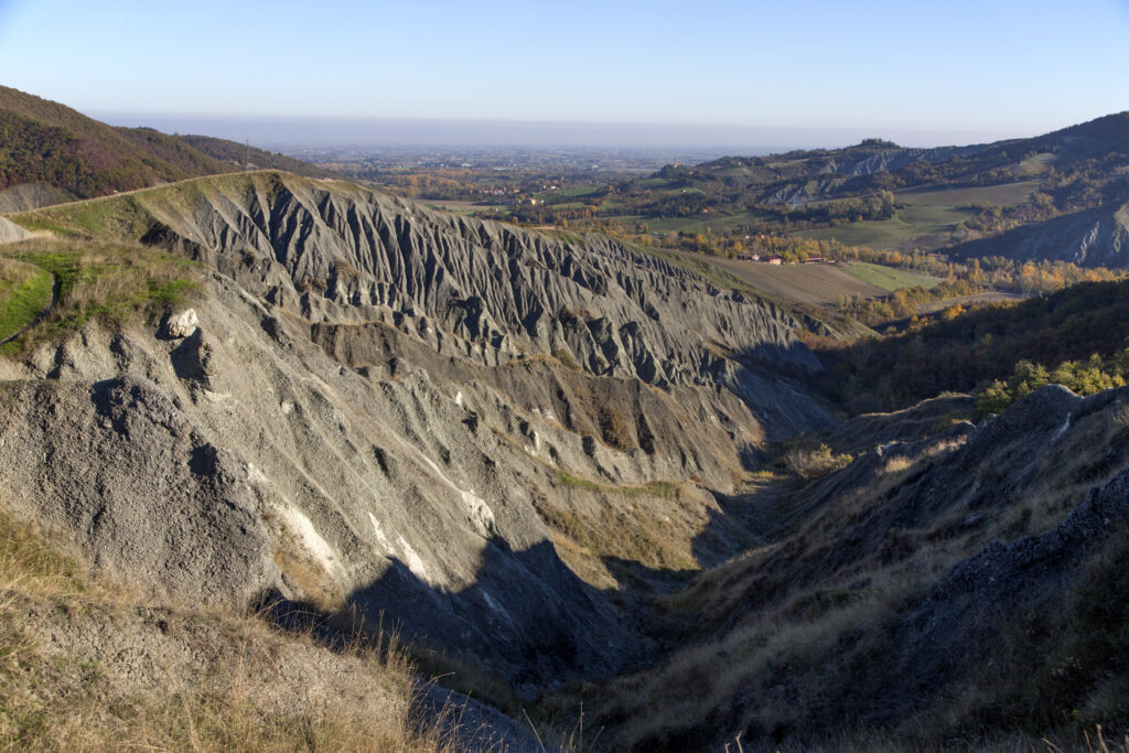
The route is of medium-easy difficulty and is mainly on secondary roads and trails. It leaves the city, heading towards the urban greenery of the Resistance Park. The path (CAI 802) climbs gently toward the Bellaria Hospital to reach Ponticella. From here a short climb and we enter the Gessi Bolognesi and Calanchi dell’Abbadessa Regional Park. With its glittering rocks and green meadows, that of the Dolina della Spipola is one of the most striking views of the route: the pride of the Park and a protected area of great naturalistic importance. Leaving the chalk area, we head toward Monte Calvo (CAI 817). The last descent skirting Buca del Budriolo brings us to Val di Zena. The first STAGE ends after a short stretch of paved road at Casa Fantini: the Park’s visitor center nestled in the green valley, as well as Luigi Fantini’s birthplace. From here you can get information about the Park and book visits to the caves. Caution very muddy sections in rainy weather. Trail with poor shade cover, to be avoided in summer.
STAGE 02
STAGE 02: From Fantini House to Gorgognano
Departure: Fantini House
Arrival: Gorgognano
Distance: 13 km
Height difference: +700m / – 450m
ACCESS:
-Farneto: SP 36 (Via Zena), Regular bus (126 not on Sundays)
-Botteghino di Zocca: SP 36 (Via Zena), Regular bus (126 not on Sundays)
-Zena: SP 36 (Zena Street)
The second STAGE of LA VIA DEL FANTINI starts at Casa Fantini, at the visitor center of the Parco dei Gessi Bolognesi e Calanchi dell’Abbadessa. The route is of medium difficulty and consists mainly of paths and secondary roads. The path (CAI 804) climbs from Grotta del Farneto toward the Gaibola Dolina, in dense forest, over chalk and clay. It follows a comfortable and shady dirt road (CAI 817) and on the left you take Strada dell’Eremo:: between villas and gentle views you arrive at the gullies of Casola Canina. The path (CAI 831) runs on the edge of two clay escarpments and must be walked with great care in case of mud. The very short variation to the left to visit the cemetery of Casola Canina is a must, passing a beautiful view of the badlands and the Idice Valley. Leaving the Regional Park, we pass by the “Poggio” viewpoint and descend to the village of Botteghino di Zocca where refreshments or lodging can be found. On Via Caurinzano (CAI 815) we head along the secondary valleys of the tributary streams of the Zena Torrent. In the locality of Brinello you take the steep path that climbs to the ridge. On a scenic path and then on a dirt road you head towards Gorgognano, an old village now disappeared but rich in memory. Nearby you can find nice resting places that can offer food and lodging.
Caution very muddy sections in case of rain: Should the ground be very wet, take CAI 815 variant to dal Brinello (via Gorgognano). Trail with poor shade cover, to be avoided in summer. The trail crosses wildlife farms; pay attention to signs for hunting trips in fall and winter.
STAGE 03
STAGE 03: From Gorgognano to Ant Mountain.
Departure: Gorgognano
Arrival: Ant Mountain
Distance: 8.5 km
Height difference: +550 m / – 330 m
ACCESS:
Zena: SP36 (Zena Street)
Monte delle Formiche: Via Monte delle Formiche
Livergnano: SP 65 (National Street), Regular bus (906) (variant)
Monterenzio: SP 7 (Via Idice), Regular buses (916, 918) (variant)
The third STAGE of the La Via del Fantini starts from the village of Gorgognano and goes all the way to the top of Monte delle Formiche. The route is of medium difficulty and consists of secondary roads and trails. Once you visit the old village of Gorgognano, you descend along the asphalt road to Zena. From here the route (CAI 815) begins its ascent, passing through Zena Castle. Near the Tower of the Heir begins one of the most compromised sections by the flood of May 2023: the path is passable paying attention but should be avoided in case of mud. On Via del Monte delle Formiche you continue to Cà di Pippo. From here, on the right, following a road for 500 meters, is the village of Tazzola, where it is possible to visit Luigi Fantini’s Botroid Museum. Following the itinerary (CAI 815) on a dirt road between the houses of Cà di Pippo, you enter the protected area of the Pliocene Spur, whose sandstone rocks are visible to the west. Entering the dense forest, you begin to climb on a steep path. On the last part of the climb, you return to the paved road that leads up to the Sanctuary of the Madonna of Zena. You pass a few meters from the centuries-old beech tree of Monte delle Formiche and find on the right ill cemetery, where Luigi Fantini rests. From the church square there is a splendid view of the Idice Valley, Castelnuovo di Bisano and Monte Bibele, the destinations of the next STAGE.
Beware of very muddy sections in rainy weather, especially the climb between Torre dell’Erede and Ca’ di Pippo: Faiedola Street and Monte delle Formiche Street are recommended if the ground is too wet. Trail with poor shade cover, to be avoided in summer. The trail crosses wildlife farms, pay attention to signage of hunting trips in fall and winter.
STAGE 04
STAGE 04: From Ant Mountain to San Benedetto del Querceto
Departure: Mount of the Ants
Arrival: San Benedetto del Querceto
Distance: 10.5 km
Height difference: +500 m / – 800 m
ACCESS
Monte delle Formiche: Via Monte delle Formiche
Castelnuovo di Bisano: Via Castelnuovo di Bisano
Quinzano: SP 22, via Zena,, Regular bus (918 not on Sundays)
San Benedetto del Querceto: SP 7 (Via Idice), Regular buses (916, 918)
The fourth STAGE of the La Via del Fantini starts from Monte delle Formiche and ends in San Benedetto del Querceto. The route is of medium difficulty and is mainly on dirt roads and paths. Beyond the forecourt of the Sanctuary of the Madonna di Zena, the route (CAI 809 b) descends among sandstone rocks, through brush, to the cemetery of Monte delle Formiche. On the left, a path descends on a flight of steps to Ca’ del Monte. Follow the paved road (CAI 809) on the left to the hamlet of Maceratoio, after which the road becomes unpaved. The trail continues to descend and we enter open fields until we reach a fork on the right (CAI 805 a) that leads us toward the Rio Cereto valley.
The original trail continues on the left to take a steep climb through the woods to the village of Castelnuovo di Bisano. Unfortunately, the climb from via Cereto to Castelnuovo di Bisano is currently not passable. An old landslide reactivated in winter 2025, and very intensive work is going on to build a high-tension pylon by Terna along the trail. Therefore, in order to avoid the most disturbed section, once you get off Ant Mountain you have to follow Cereto Street to the right to reach Zena Street. Follow via Zena to the left to the junction with via Castelnuovo, which you follow to the original path to the right.
CAI 805, which, among farmhouses and cultivated fields, leads us along a final climb through the woods to the Monte Bibele Archaeological Nature Area. Refreshments and information for tours of the archaeological area can be found at the Monte Bibele Service Center. After a visit to the Etruscan-Celtic village of Pianella di Monte Savino, descend toward Quinzano along the “Via della Carrozza” (CAI 803, 803 a) and then toward the Idice Valley at San Benedetto del Querceto (CAI 805). Here you can find public transportation to return if you wish, or follow other routes on foot.
Caution very muddy sections in rainy weather. Trail with poor shade cover, avoid in summer. Trail crosses wildlife farms, pay attention to signs of hunting trips in autumn and winter. Pay attention to the marked variant (via Cereto – Castelnuovo di Bisano).


La Via del Fantini
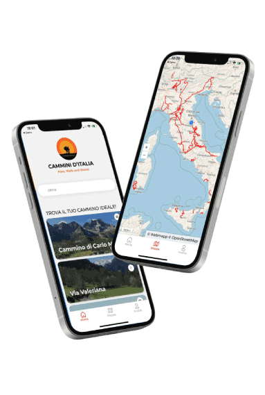
With Cammini d’Italia’s free app, you can plan and walk La Via del FANTINI in complete safety, being able to plan the STAGE in detail and walk the route thanks to the built-in GPS technology that supports you in orientation during your adventure.
Within the app you will find many other paths present in Italy. Thanks to the georeferenced tracks of many routes you will be able to study the itinerary that suits you best and also download the GPX tracks of the individual STAGEs offline.
The app also includes a complete digital map of all the paths surveyed to date on our portal, giving you a wide range of choices among the many paths in the Belpaese.
⠀⠀
Cammini d’Italia is the perfect app for those who want to explore the beauty of Italy on foot, discovering hidden places surrounded by nature. Download it for free today and start planning your next adventure!
 ⠀⠀⠀
⠀⠀⠀