Via Ellenica - Cammino Materano
166 km, 8 STAGE discovering Puglia among forests, farms and landscapes of unusual beauty, we discover charming villages that, for millennia, have been crossroads of cultures and treasure chest of peasant traditions
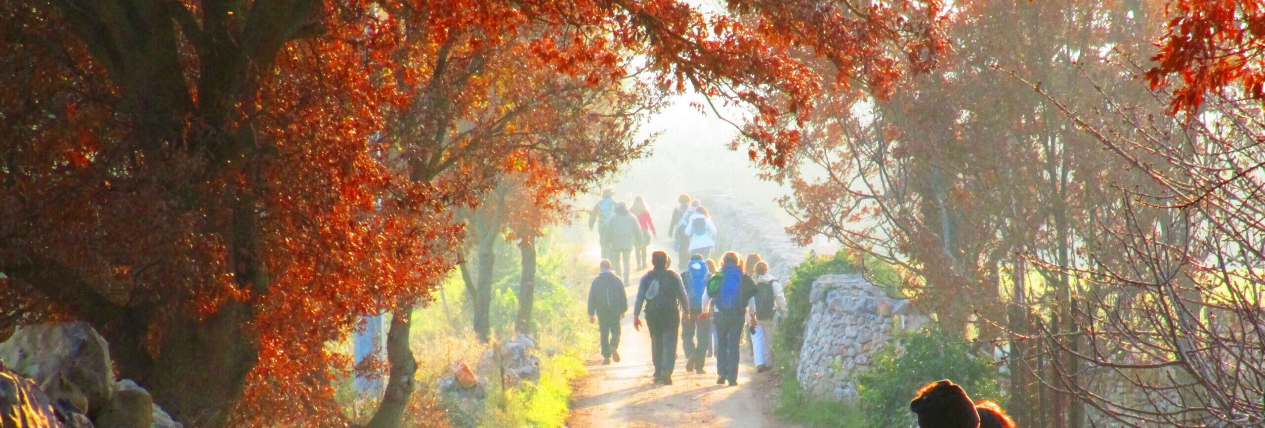
The Hellenic Way connects two Unesco sites, Alberobello and the Sassi di Matera, and crosses the fascinating Terra delle Gravine, an area dotted with multiple natural and man-made wonders: starting with the deep and spectacular rocky gorges (Canyons) that are home to ancient villages and rock churches, decorated with precious frescoes from medieval times. Along the Camino, embellished by forests, farms and landscapes of unusual beauty, one discovers picturesque villages that, for millennia, have been crossroads of cultures and treasure chests of peasant traditions.
The STAGE points are Martina Franca, Crispiano, Massafra, Mottola, Castellaneta, Palagianello, Laterza and Ginosa.
The Camino, which includes 8 STAGES totaling 166 km, is complete in terms of signage and accommodations.
WATER
Water sources are not always present along the STAGES, so it is recommended that you leave each day with a good supply of water; however, there is no shortage of farms and farmhouses where you can stock up on water.
SERVICES
All essential services are present at each STAGE point.
SIGNAGE
The Trail is fully marked in paint (yellow-green) and wooden signs
ROAD BOTTOM.
50% asphalt, 50% dirt
IN TENT
There are currently no accommodations where tents can be pitched
CREDENTIAL
The credential is obtained by filling out the application form
https://camminomaterano.it/credenziale-del-pellegrino
CONTACTS
CONTACT
E-mail: camminomaterano@gmail.com
STAGE 01
STAGE 01: Alberobello to Martina Franca
Departure: Alberobello
Arrival: Martina Franca
Distance: 18 km
Height difference: +281 m / – 257 m
We leave Alberobello along the paths of Bosco Selva, a remnant of a more extensive oak forest that once covered a large part of this area. The forest cover consists mainly of strawberry, holm oak and downy oak trees (typical elements within the Apulian landscape), but numerous shrubs also grow there, including strawberry trees, mastic trees and the priest’s caps. Once past the forest, the route winds through paths and narrow streets framed by dry stone walls and immersed in the typical agrarian landscape consisting of wheat fields, olive groves and vineyards, farmhouses and masserias. The STAGE ends in Martina Franca, baroque pearl of the Itria Valley.
STAGE 02
STAGE 02: Martina Franca to Crispiano
Departure: Martina Franca
Arrival: Crispiano
Distance: 27.6 km
Height difference: +390 m / – 582 m
The STAGE takes place largely along trails that pass through a series of wooded areas of great naturalistic value. The first of these is the Murge Orientali Oriental Nature Reserve, then along trails and contrade to the Pianelle Forest, one of the most important and extensive green lungs in Puglia; we cross the forest walking inside it for a good 7 km to finally arrive in Crispiano, the city of a hundred farms as well as the watershed between the Itria Valley and the Terra delle Gravine.
STAGE 03
STAGE 03: Crispiano to Massafra
Departure: Crispiano
Arrival: Massafra
Distance: 17.9 km
Height difference: +108 m / – 256 m
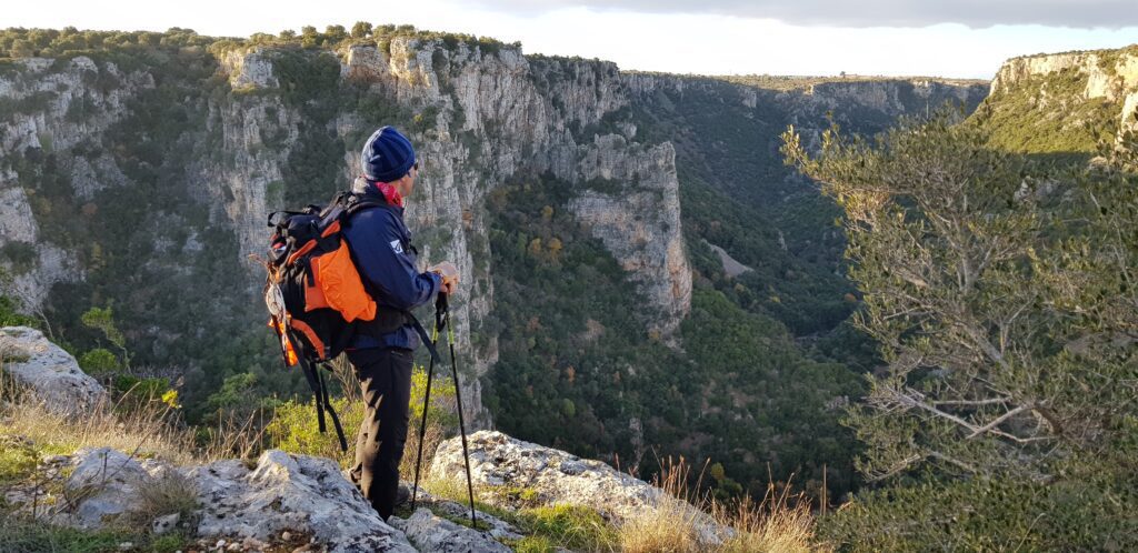
From Crispiano the traveler slowly enters the Terra delle Gravine, one of the most important naturalistic areas in Europe, consisting of impressive karst canyons arranged in a fan shape around the Ionian arc of the Gulf of Taranto. You leave Crispiano walking for a few kilometers just inside a small ravine (of Triglie), following a path that runs in the riverbed among the dense vegetation typical of the Mediterranean maquis and traces of rock settlements. The path continues to Masseria Amastuola, an ancient farmhouse from the 1400s surrounded by an enchanting garden vineyard designed by the well-known landscape architect and philosopher Fernando Caruncho.
STAGE 04
STAGE 04: Massafra to Mottola
Departure: Massafra
Arrival: Mottola
Distance: 26.1 km
Height difference: +511 m / – 234 m
We start from Massafra, one of the capitals of Italian rock art so much so that it has been nicknamed the “Tebaide of Italy”; in fact, the town rises between two ravines dotted with caves and hypogean environments that preserve extraordinary evidence of the life that man has led there for millennia. A long path winding among centuries-old olive trees allows you to leave the city and enter the silent countryside where cultivated fields and Mediterranean scrub alternate. The Path then crosses the Bosco di Sant’Antuono, one of the most valuable naturalistic areas in Puglia.
STAGE 05
STAGE 05: Mottola to Castellaneta
Departure: Mottola
Arrival: Castellaneta
Distance: 16 km
Height difference: +294 m / – 444 m
One descends from the hill on which Mottola stands via an ancient sheep-track that leads to an area rich in rock settlements including the village of Casalrotto and the church of Sant’Angelo, the only rock church in Italy to be arranged on two floors. After a few kilometers the wayfarer encounters on his way another rock church, that of San Nicola, an amazing picture gallery of Apulian popular sacred art of the Middle Ages. It continues in the direction of Palagianello to finally arrive in Castellaneta: both towns rise close to imposing ravines; that of Castellaneta, is one of the largest and most spectacular in Puglia.
STAGE 06
STAGE 06: From Castellaneta to Laterza
Departure: Castellaneta
Arrival: Laterza
Distance: 29.7 km
Height difference: +783 m / – 687 m
This is one of the most fascinating STAGES of the entire walk because of the extraordinary variety of environments and landscapes that you pass through. You leave Castellaneta walking, among expanses of olive trees, along a series of small roads and paths that lead toward the Montecamplo nature reserve. We cross a vast area totally covered with Mediterranean scrub and officinal plants to finally take an extraordinary path that runs for several kilometers along the edge of the Laterza ravine, one of the largest canyons in Europe with walls more than 200 meters high: a marvelous naturalistic paradise, vast and uncontaminated, is revealed to our eyes, giving us breathtaking landscapes and views at every step.
STAGE 07
STAGE 07: Laterza to Ginosa
Departure: Laterza
Arrival: Ginosa
Distance: 16 km
Height difference: +253 m / – 341 m
From Laterza, the journey continues on country roads immersed in olive trees that accompany us to the pine forest of Murgia San Pellegrino, an area traversed for millennia by shepherds who, in transhumance, traveled from Basilicata to the plains of Taranto. The wayfarer is greeted in Ginosa by an extraordinary complex of rock villages, known as the Casale and Rivolta, characterized by a large number of cave-houses arranged on several levels connected by stairs and paths: the two villages were inhabited until the first half of the 20th century and preserve traces of ancient and recent life.
STAGE 08
STAGE 08: From Ginosa to Matera
Departure: Ginosa
Arrival: Matera
Distance: 27.1 km
Height difference: +532 m / – 377 m
A beautiful contrada leads into the Lucanian hills, characterized by expanses of arable land and olive groves, while majestic birds of prey circle the skies, accompanying the wayfarer for much of the STAGE. For a few kilometers, one walks along an evocative path that runs close to the Matera ravine: a deep canyon dotted with cave-houses and rock-hewn churches reveals itself to the wayfarer’s view. The arrival in Matera is from the Casalnuovo district: a narrow passage carved into the rock leads into the presence of the extraordinary and ancestral beauty of the Sassi that constitute the destination of the walk.


Listen to our podcast
Via Ellenica - Cammino Materano
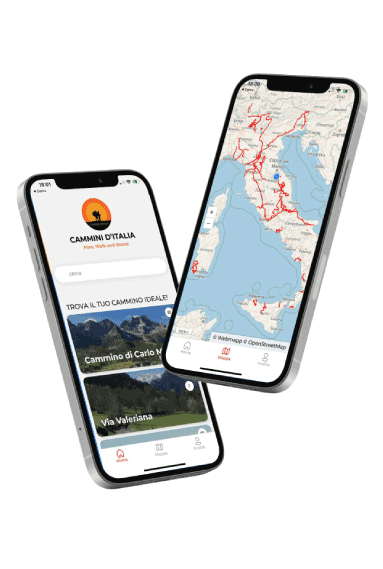
With the free Cammini d’Italia app you can plan and walk the Hellenic Way in complete safety, being able to plan the STAGE in detail and walk the route thanks to the built-in GPS technology that supports you in orientation during your adventure.
Within the app you will find many other paths present in Italy. Thanks to the georeferenced tracks of many routes you will be able to study the itinerary that suits you best and also download the GPX tracks of the individual STAGEs offline.
The app also includes a complete digital map of all the paths surveyed to date on our portal, giving you a wide range of choices among the many paths in the Belpaese.
⠀⠀
Cammini d’Italia is the perfect app for those who want to explore the beauty of Italy on foot, discovering hidden places surrounded by nature. Download it for free today and start planning your next adventure!