Cammino di San Filippo Neri
The Cammino di San Filippo Neri is a route of about 120 km divided into 7 STAGES that retraces the footsteps of the first pilgrimage made by the Saint of Joy.
The Cammino di San Filippo Neri is not only a route to be taken on foot, by bike or on horseback but a recommendation for those who think of taking time for themselves without having to go too far! Those who want to walk this Camino will find themselves among places they have never seen before and others that are also well known, but with decidedly different eyes.
This Camino is not just trekking, nor just tourism, it is a journey of the spirit. An immersion in the land that will take one thousand to zero and zero to a thousand! Welcoming, authentic warmth, nature to satiate the eyes and breath and finally... the answers that always a path holds specific for each pilgrim's questions.
The Cammino di San Filippo Neri is a route of about 120 km divided into 7 STAGES that retraces the footsteps of the first pilgrimage made by the Saint of Joy. It starts from Cassino, the old San Germano, in the shadow of the most important monastery in the world. In the first STAGE we will follow the course of the Gari and Garigliano rivers and pass through the two historic centers of S.Angelo and S.Ambrogio, resurrected after the ravages of the last world war. Among the banks of the waterways, it will be possible to admire flora and fauna that are at times unique.
HISTORY
The Cammino di San Filippo Neri was created in 2022 at the initiative of some secondary school teachers who were passionate walkers and proposed to its creator to give the Cammino di San BENEDETTO an outlet to the sea. While they were mapping out the routes, they noticed that some of the places involved had plaques commemorating the passage of St. Philip Neri.
WATER SOURCES.
WATER CAMMINO DI SAN FILIPPO NERI
STAGE 01: Cassino-S.Ambrogio S.G.
Length: 19.4 km
Numerous water sources are present in the city center (Cassino is a city rich in water and springs), however we recommend that you stock up at the Horti di Porta Paldi, the last remaining area in the city center from which you can drink directly at the source (41°29’06 “N – 13°49’33” E). The second spring present in the first STAGE is in the historic center of S.Angelo, almost halfway from the start (41°26’41 “N – 13°49’57” E). Just before reaching S.Ambrogio it will be possible to quench one’s thirst at the Fosso della Foresta spring, an ancient spring nestled in the woods (41°23’09 “N – 13°52’23” E)..
STAGE 02: S.Ambrogio sul Garigliano -S.Andrea del Garigliano
Length: 10.7 km
The second STAGE is the shortest of the entire Camino. In addition to the historic center of Sant’Ambrogio sul Garigliano where you can refuel with water, there are two other possibilities near the fountain of the forest ditch and at the picturesque Solomon spring, just before arriving at the Bosco d’Olmi.
STAGE 03: Bosco d’Olmi (S.Andrea del Garigliano) – Madonna del Piano (Ausonia)
Length: 18.05 km
On this third STAGE, it will be necessary to refuel with water at the start since for about 12 km until the passage through the historic center of Coreno Ausonio, there is no source. About 1 km before the arrival at the Sanctuary of Madonna del Piano, near the underpass of the freeway, there is a providential drinking fountain.
STAGE 04: Madonna del Piano-Esperia
Length: 12.1 km
This is the STAGE with the most sources at which to refuel with water. From the arrival at the selvacava pine forest until the end of the STAGE, it will be possible to draw from the many sources along the road.
STAGE 05: Esperia – Filetto (Acquaviva shelter)
Length: 24.4 km
It is, along with the next, the STAGE where there is the most difficulty in water supply. It is best to stock up at the drinking fountain located immediately outside the mountain gate in the old town of Roccaguglielma. In fact, in the next 14 km there are no sources on the route. The ‘only chance to draw water is at Fontana di Canale, a high-altitude spring located more than a km from the Cammino route by making a detour near the Pic nic area of Valliera. The Pornito refuge is located about 21 km from the start and 3 km from the end of the STAGE.
STAGE 06: Filetto (Rif. Acquaviva) – Madonna della Civita
Length: 16.5 km
On this STAGE for about 13 km it will not be possible to refuel with water. It is advisable to contact the managers of the Acquaviva refuge to inquire about the possibility of taking water from the Acquaviva Spring, which in some periods of particularly dry years remains dry.
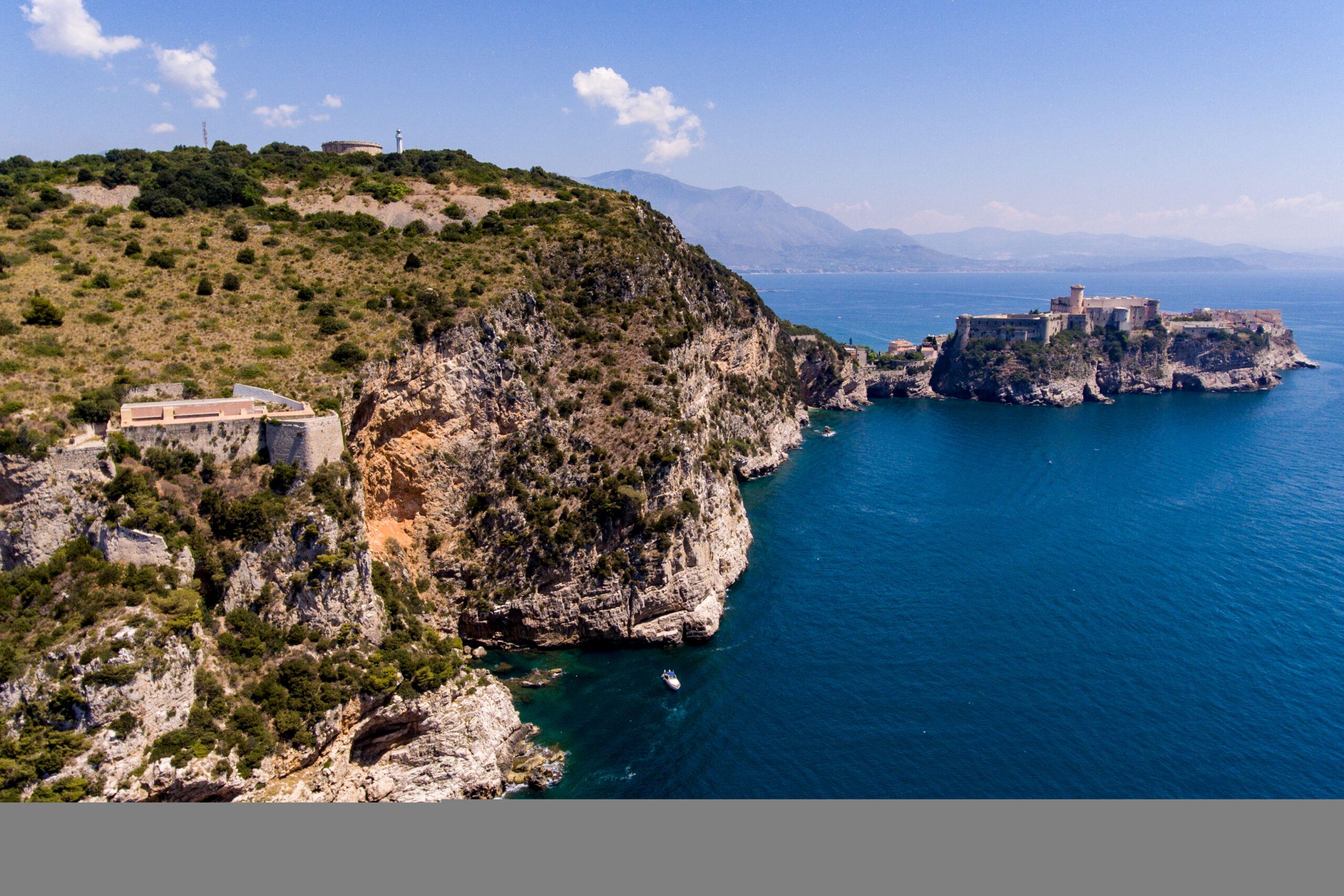
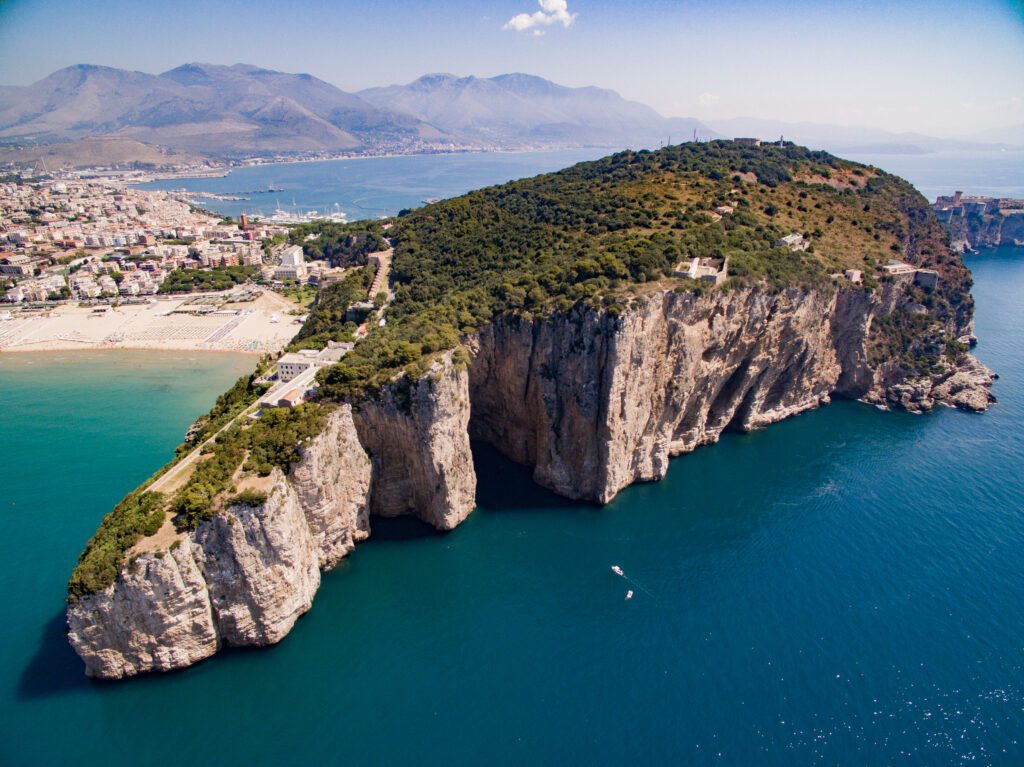
STAGE 07: Madonna della Civita (Itri) – Montagna Spaccata di Gaeta
Length: 20.9 km
From the start at the sanctuary of the Madonna della Civita after about 5 km, we pass through the historic center of Itri where we will necessarily need to refuel with water because for about 11 km, until the port area of Gaeta.
STAGE
STAGE 01: Cassino to S.Ambrogio sul Garigliano
Length: 18 km
Height difference: + 180 m
From the headwaters of the Gari River near the Mother Church of Cassino, the route from the urban core, through the Horti di Porta Paldi, enters the countryside that laps the crystal-clear waters of the watercourse. It follows the course of the river and reaches the historic center of Sant’Angelo in theodice after a few kilometers. You then pass by the peace bell monument and, following the course of the gari river, you reach via Mutaro, an ancient road axis built by the ancient Romans that is now partly paved. Following via Mutaro the roadbed made of asphalt soon becomes paved and finally dirt until the S.Ambrogio bridge over the Garigliano, on the border with Campania.
Cross the arched bridge over the Garigliano River and turn left immediately afterwards, near the Sant’Ambrogio sports facilities. From here on the plain you reach the ancient via Castagna and the Fontanile di fosso della Foresta at the base of the hill on which the center of Sant’Ambrogio sul Garigliano is located. From the Fontanile to the small town there are only a few hundred meters to go unfortunately uphill on a very steep concrete road.
STAGE 02: S.Ambrose-S.Andrew
Length: 10.7km
Height difference: +140m
The second STAGE of the Cammino di San Filippo Neri is the shortest of the entire route. From the historic center of Sant’Ambrogio sul Garigliano one descends through Via Castagna near the area near the Garigliano River. From here one crosses cultivated fields and deciduous forests that come to lap the course of the river. Twenty minutes after the start, it will be possible to make a small detour of about 15 minutes from the trail to visit the recirculation waterfall nestled in the woods of Sant’Ambrogio sul Garigliano.
A little further on, continuing along the route of the path, you will look at the Rio delle pecore, so called because its waters were once believed to have medicinal effects for the flocks. From here via via tranzana you will take the road that leads to the Scafa wharf and, soon after, to the wonderful Solomon spring. Here you should make a restorative stop, taking advantage of the cool acidic drinking waters that flow copiously from a cavity in the rock. From the spring another 3 km separates you from the STAGE destination at Bosco D’Olmi, in the municipality of Sant’Andrea del Garigliano.
STAGE 03: S.Andrea -Madonna del Piano (Ausonia)
Length: 18 km
Height difference: +900
From Bosco D’Olmi in the municipality of Sant’Andrea del Garigliano yes in the mouth the small road that starts near the old drinking water reservoir slightly downhill and, keeping to the left, climbs steadily for about three kilometers until turning left onto an obvious climb with a stony bottom. We still climb into the cool and very shady hornbeam forest just before reaching the pass where a few ups and downs separate us from Vallaurea. This is a plateau formerly much frequented by shepherds and ranchers characteristic of the southern part of the Aurunci Mountains.
After turning left near a cistern you reach the first real panoramic view of the Tyrrhenian Sea near the Marinaranne Peace Monument. From here you descend on a descent that is cemented in places until you take, going downhill to the left, the road that runs through the entire historic center of Coreno Ausonio. Has crossed the center you will turn left in the direction of the entrance to Via Serra, an ancient road that led from the hill to the plain. In about 4 km you will reach the shrine of Madonna del Piano in Ausonia.
STAGE 04: Madonna del Piano – Esperia
Length: 12.1 km
Height difference: +400
The fourth STAGE of the Cammino di San Filippo Neri starts from the sanctuary of Madonna del Piano in Ausonia. We climb the slopes of Mount fammela in a Mediterranean environment rich in terraces and dry stone walls. After a few kilometers you pass by the Antica chiesa di correano a splendid 10th-century structure. From here you climb further until you reach the Selvacava pine forest and, immediately after, the Bastia hill. A few ups and downs and immediately turn left leaving the paved road when the village of Esperia begins to appear in the distance. Continue on a paved roadbed to the pleasant Aurelio Valley and, in a short time, reach via Castagne. Continue through terraces and chestnut groves until you reach the San Filippo Neri polling station, the arrival point of the fourth STAGE.
STAGE 05: Esperia to Filetto di Formia (Acquaviva refuge)
Length: 24 km
Height difference: + 1050
The fifth STAGE of the Cammino di San Filippo Neri is certainly the most challenging but, equally, the most beautiful. From the historic center of Upper Esperia, one passes through the gorge of the Rio Polleca and ascends to the heart of the Monti Aurunci park.
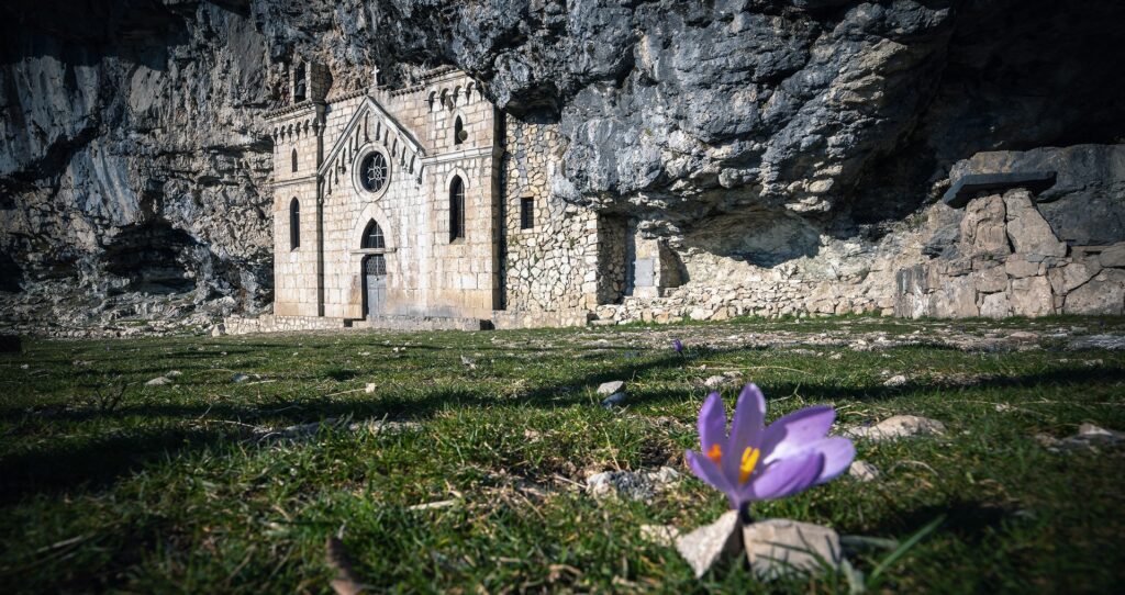
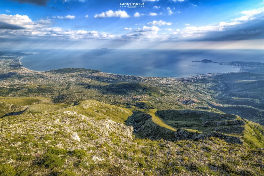
You then cross the valleys of Pollica and Fraile between maple and beech forests, agro-sylvo-pastoral settlements where shepherds still produce marzollina, the Caprino cheese best known in these parts. From the Polleca-Fraile plateau, climb further to the Forcella di Fraile, about 1,000 meters above sea level, and turn left in the direction of Monte Altino. From here countless views of the Gulf of Gaeta and the Ponzi islands satiate the eyes and the spirit. We find ourselves in the most scenic spots on the Camino and probably in all of peninsular Italy. On the clearest days the gaze embraces almost 150 km of coastline: from the Aurunci peaks we can admire a panorama that reaches from the island of Capri to the promontory of Circeo. Continue on the road that passes north of Monte Altino and arrives at the Valliera picnic area where you will need to turn right onto the obvious dirt road that climbs towards the Redentore, the highest point of the Cammino di San Filippo Neri. At the summit a stop is a must to catch your breath and admire the incredible view. You can recognize the Gulf of Naples with the Parthenopean islands and Vesuvius, the estuary of the Garigliano River, the Ponzian islands, and the beautiful promontory of Gaeta. But the beauties of this place are not finished, in fact, it will be enough to walk back and walk the few hundred meters that separate the redeemer from another great attraction: the hermitage of St. Michael the Archangel.
On the outside, the facade built more than 1,200 years ago hides an interior consisting of a very large natural cavity. Every year the people of Maranola carry the statue, in procession, to this evocative place in June and then bring it back down, to the village, in September. From the hermitage of St. Michael the Archangel we descend the statue’s path to the Pornito refuge, and from here, crossing the Campone Picnic Area, we shortly reach the Acquaviva refuge area, the destination of the fifth STAGE.
STAGE 06: From Filetto di Formia (Acquaviva refuge) to the Sanctuary of the Madonna della Civita (Itri)
Length: 16 km
Height difference: + 750
From the Acquaviva Refuge, you climb in altitude until you reach the area of Mount Mesole. It climbs through the oak and beech forest reaching the karst sinkhole of Fosso di Fabio. Not far away are still the remains of an f104 that crashed in 1985. Even today shepherds bring flowers to the grave of the poor pilot. We begin to descend toward the Piana di Campello by skirting the best-preserved neviera in the Monti Aurunci park. These artifacts were large cisterns in which snow was stored until the summer and sold to coastal towns for a variety of uses.
That of snow trading was a very profitable activity until the early 1900s. From the snowfield, one arrives in a short time at the Old Campello Fork, and from here to turn counterclockwise on Mount Castellone one reaches Valle Torre and the farm of the same name. From Valle Torre through the trasta area you will shortly reach the San Nicola pass, near the Oxygen hostel. From the oxygen hostel to the shrine of Madonna della Civita is about 3 km of paved road.
STAGE 07: From the Sanctuary of the Madonna della Civita (Itri) to Gaeta’s Montagna Spaccata
Length: 20.9 km
Height difference: + 350
The last STAGE of the Cammino di San Filippo Neri starts from the sanctuary of the Madonna della Civita where a marble epigraph still commemorates the passage of St. Filippo Neri in 1532. You descend about 5 km from the raino area and take the road that soon reaches the town of Itri. Ittiri is known for the variety of olives called Itrana and because it still preserves a beautiful historic center on the hill separated from the more recent settlement by the Appian Way. From Itri take the foothill road towards Sperlonga and turn left onto via delle Vignole. This paved road will be traveled to the end of the second major climb and that is to the pass between Mount Dragone and Mount Carbonaro.
Here you will turn left onto an obvious cemented road and keeping to the right you will reach the saddle that connects with the Gaeta roadstead. You will then descend again along this cemented road until it ends on the left in an obvious paved track with a few steps, again in stone. This track will shortly lead to the Cistercian Grancia of San Vitale. The path descends halfway down a slope that was once densely planted with olives. As soon as you arrive down near the Cistercian Grancia of San Vitale, once an ancient Roman Villa, continue downhill until you reach the paved road and turn right passing near the oil deposits. Immediately you will go in the direction of the Port passing by a winery house. Right here you have to be very careful because in front of the entrance to this business is the old railroad track that you will have to take until you reach the Don Bosco elementary school. From here you turn left downhill onto Via Calegna and, having reached the traffic circle near the Port you will have to turn right onto Via dell’Indipendenza. This wonderful street was built by the Bourbons and is still an authentic place to walk with your eyes upward. It will be necessary to walk all the way to Piazza XIX Maggio, near the town hall of Gaeta.
The date that gives the square its name comes from the day the U.S. Army landed in the Laziale town. Once through the entire town square it will turn right to the intersection with Via Munazio Planco. This road will lead all the way to the arrival of the Cammino di San Filippo Neri at the sanctuary of the Holy Trinity at Montagna Spaccata in Gaeta. Just before turning onto via munazio Blanco you can continue for another 100 meters and reach Serapo beach for a refreshing swim. Gaeta’s sea is wonderful.
SERVICES
In all centers crossed by the walk there are services such as supermarkets pharmacies bars and restaurants. Some of them have an agreement with the association of the Friends of the Cammino di San Filippo Neri to allow Pilgrims/Wanderers advantageous treatment. The only STAGES that do not have facilities in the immediate vicinity are at the arrival of the second and fifth, in these cases it will be necessary to make arrangements in advance and talk to the managers of the accommodations.
SIGNAGE
Signage present along the way
DANGERS
Throughout the walk there are no particular dangers in some mountainous areas it will be possible to encounter flocks and therefore shepherd dogs. Particularly in the third STAGE when crossing Vallaurea, in the fifth STAGE when passing through the valleys of Pollica and Fraile, and in the sixth STAGE in the Valle Torre area. How to behave when in the presence of sheepdogs? Stopping and trying to exchange a few words with the shepherd is always a good idea. The goal of the sheepdogs is to defend the herd animals, if they perceive you as a danger to the animals they protect then there may be some problem otherwise you have nothing to fear. Usually the sight of the sticks is more than enough to keep them from approaching.
ACCESSIBILITY
The entire walk is usable by people with reduced mobility. Some sections where walking remains somewhat difficult have been noted (and facilitating alternatives proposed) in the guidebook “Ol Cammino di San Filippo Neri a piedi” Ediciclo Editions.
ROAD BOTTOM.
15% of the total
CREDENTIALS
Credentials are free; the association only charges a small fee for postage and handling costs.
TENT WALK
CAMMINO DI SAN FILIPPO NERI IN TENT
National regulations allowing free bivouac from dusk to dawn are implemented in all municipalities of the Camino. Contacting the association provides more information on facilities that accommodate tent owners free of charge.


Journey diaries
Cammino di San Filippo Neri
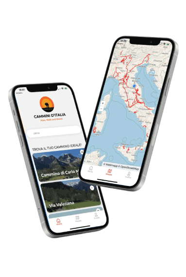
With the free Cammini d’Italia app, you can plan and walk the Cammino di San Filippo Neri safely, being able to plan the stages in detail and walk the route thanks to the built-in GPS technology that supports your orientation during your adventure.
⠀Inside the app you will find many other paths present in Italy. Thanks to the georeferenced tracks of many routes you will be able to study the itinerary that suits you best and also download the GPX tracks of the individual STAGEs offline.
The app also includes a complete digital map of all the paths surveyed to date on our portal, giving you a wide range of choices among the many paths in the Belpaese.
⠀⠀
Cammini d’Italia is the perfect app for those who want to explore the beauty of Italy on foot, discovering hidden places surrounded by nature. Download it for free today and start planning your next adventure!
⠀
⠀
 ⠀⠀⠀
⠀⠀⠀