Grande Anello dei Borghi Ascolani
A combination of nature, history, breathtaking landscapes and ancient flavors
A 100-km-long journey, divided into seven STAGES, through the magnificent hilltop villages at the foot of the Ceresa, Monti Gemelli, Sibillini and Monti della Laga mountain ranges, included in the
municipalities of Ascoli Piceno, Venarotta, Comunanza, Roccafluvione, Montegallo and Acquasanta Terme. The common thread of the historical-naturalistic route is the defensive apparatus of the ancient state
of Ascoli, which in the Middle Ages could count on as many as 32 castles subject to its jurisdiction. In the enchanted atmosphere of medieval villages, among ruins of ancient castles and solitary hermitages, the
path becomes a memorable experience to get to know one of the most fascinating places in the Marche region and meet the warmth of its people.
HISTORY
The walk is being planned during the 2020 lockdown, to be officially unveiled in spring 2021. It was created at the initiative of members of Le Marche Experience Association (tour guides and environmental hiking guides of the Marche Region), with the aim of reviving slow tourism in the depressed areas of the central Apennines, hard hit by the 2016 earthquake. It unites the territory of 6 municipalities, touching on the most significant historical-artistic and naturalistic emergencies in the area.
The project was supported by the Marche Region, the Municipality of Ascoli Piceno and the Carisap Foundation.
STAGE
STAGE 01: Ascoli Piceno – Venarotta Castle
Length: 18.6 km
Height difference: 600 m d+
Ascoli Piceno’s starting and finishing point for this hiking route through history, nature and landscape is the splendid Piazza del Popolo, a jewel of the Italian Renaissance and one of Italy’s most fascinating living rooms. From here we move north through Piazza Ventidio Basso, site of the ancient city market, then walk along the Roman Augustan bridge crossing
the Tronto River.
Having reached the square of the municipal cemetery, continue along Via San Serafino da Montegranaro through the Caprignano and Casamurana districts, thus arriving at the village of Mozzano.
A grassy path leads off from the first houses in the village up to the old castle village. The old people of the village still remember the high walls of the ruined fortress on the summit of a steep tuffaceous hill overlooking the village. Of this, unfortunately, we have little news; we do know, however, that Mozzano Castle was a 1st-grade castle; sections of fortifications are still visible in the southwestern sector, consisting of a section of polygonal curtain wall equipped with bombardier and musket embrasures.
Following the path that climbs the hill, we come across, nestled in the green bush, the small church of Sant’Emidio di Tronzano, with its simple quadrangular body built of sandstone blocks and sloping roof.
The interior is very interesting, as it is considered a true shrine of popular devotion in the period between the 15th and 16th centuries. Indeed, the walls preserve several frescoes in good condition, several panels bearing effigies of saints commissioned by local landowners for the purpose of intercession.
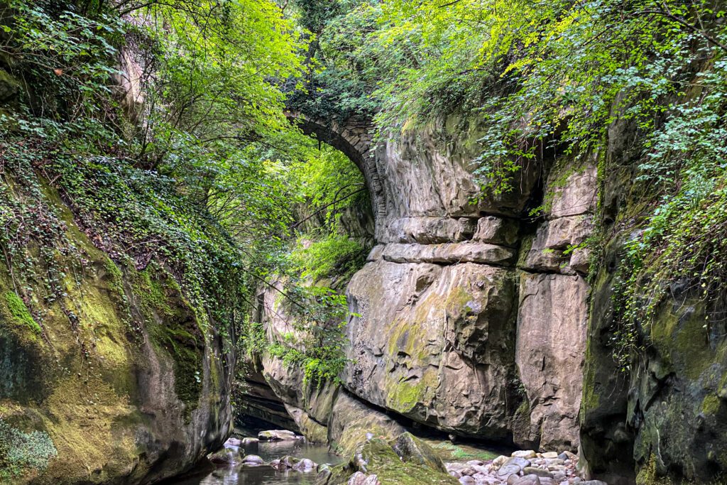
Some panels also show the dating of the works (1488-1505) and the name of the commissioning family. We then cross the town of Tronzano and take a cartroad that offers a beautiful panoramic view of the Sibillini Mountains chain; from here we descend by a path directly to the small hamlet of Casacagnano (Municipality of Roccafluvione), then reach the hamlet of Ponte Nativo located along the banks of the Fluvione, which narrows here to form a natural bridge (hence the name of the hamlet). The bridge already existed in the Middle Ages, mentioned in 1381 as a villa included in the district of the castles subject to the city of Ascoli Piceno, which is why we still find it represented in the coat of arms of the Municipality of Roccafluvione.
From the hamlet of Casacagnano, we take a cart track that climbs in a northerly direction through a small forest, then we reach the hamlet of Casamaruccia di Venarotta where there is the Convent of St. Francis, the arrival point of our STAGE.
It is one of the first convents founded by the Franciscan order in the Piceno region.Tradition has it that a temple dedicated to the goddess Venus stood on this hill; in the 8th century it would become a place of prayer and solitude for a few hermits.It can be assumed that the hermits founded the convent to conform to the rule of the Saint of Assisi.
Accommodations: Hostel San Francesco, B&B Villa La Passione, hotel/restaurant Il Casolare
STAGE 02: Venarotta Castle – Ficocchia
Length: 13.3 km
Height difference: 620 m d+
From the Convent of St. Francis, one travels along a stretch of paved road and then joins a cartroad that briefly climbs a scenic hill passing by a farm and finally descending along the Cinante ditch, which one crosses to take one along the Fluvione Valley. This valley still holds some important artifacts of vital importance to the economy of these rural areas: hydraulic mills. Among them is the Pignoloni Mill, which dates back to 1629 as reported by the lintel on the north side-a true jewel of hydraulic engineering! Its retrecine shaft of considerable length is placed outside the structure in order to take advantage of the water jump from the Arena waterfall once the shutters are opened.
We now set off again in the direction of Pedara di Roccafluvione, first making a brief stop at the Church of Sant’Ippolito e Cassiano, made of sandstone and with low arched windows. Its tower is located in adherence to the front of the church on the centerline of the façade: this is a rare architectural solution, a type of attic bell tower where the belfry stands before the entrance portal, forming a protective portico on the first floor. The structure had the dual task of protecting the community from outside attacks and guarding valuable stocks of crops and processed products in times of famine.
The small settlement of Pedara hides a small treasure of biodiversity: the ancient vineyard of the Fabiani winery, cultivated with native vines planted free-range as they used to do before 1860-1870, that is, before the arrival in Italy of phylloxera (a phytophagous insect that attacks the roots of the vine).
From these ancient vines, cultivated with traditional techniques in perfect
harmony with the environment, a wine of excellent quality is produced.
After a short stop for refreshment, we resume our walk by taking the path that leads to the Pizzorullo hill. Here we encounter the ruins of Pizzorullo Castle shrouded in lush vegetation on top of the lonely hill overlooking the upper Fluvione valley.
As of the 13th century, the Castle of Pizzorullo is reported to be subject to the State of Ascoli. We then continue to the colony of Ficocchia, stopping at the huge sandstone bank overlooking the Fluvione valley, where there is a splendid view of the Sibillini Mountains.
Accommodations: Holiday House Ficocchia, Room Rentals Il Borgo del Vento in Vindola, b&b Casa Romè
STAGE 03: Ficocchia – Abetito
Length: 11 km
Height difference: 530 m d+
From the colony of Ficocchia, take a path through a dense forest downhill until you reach the hamlet of Uscerno (Municipality of Montegallo). From here you cross a small bridge over the Fluvione River and take a cartroad that climbs up to the village of Meschia (Municipality of Roccafluvione). Arriving at the village, one is struck by these huge rounded boulders of sandstone that are used by sportsmen who practice “bouldering” (rock climbing activities).
Some houses in the village rest directly on the sandstone rock and are reached by stairs carved into the bare rock!
Concerning traditions, in this small mountain village, as in others in the area, the trade of the “charcoal burner” was widespread. In fact, a small museum dedicated to charcoal burners has been set up here.
After the lunch stop, the trail leads back to the village of Abetito (Municipality of Montegallo).
Accommodations: Agriturismo Casa Vecchia, B&B Il Castagneto dei Sibillini; in case of unavailability of accommodations in Abetito you can stay overnight in Meschia in the b&b I Massi
STAGE 04: Abetito – Fork
Length: 10.6 km
Height difference: 460 m d+
This is the STAGE where nature triumphs. We are located within the beautiful and pristine Lost Apennines area, within the Ceresa mountain range, where you will encounter many abandoned villages.
You will pass through chestnut and beech forests until you reach an altitude of 1,200 meters where you can enjoy extraordinary views of the Vettore massif and the Fluvione valley. Very interesting are the rock settlements of Piandelloro, characteristic dwellings built against the sandstone rock walls with rooms used as stables and barns. The STAGE will end at Forcella, a medieval village perched on a rock terrace.
The ditch of colors and the rock settlements of Piandelloro By walking along the convenient path that was once the ancient connecting route between the village of Piandelloro and the valley floor, you can see houses set in the rock (examples of rock buildings) that were inhabited until the 1950s! The path winds through mixed forests (chestnut and ilex groves) and sandstone banks. Very striking are the colors and scents of the floristic species, especially in springtime
Accommodations: Farmhouse Arcera Forcella
STAGE 05: Fork – Valledacqua
Length: 10.9 km
Height difference: 590 m d+
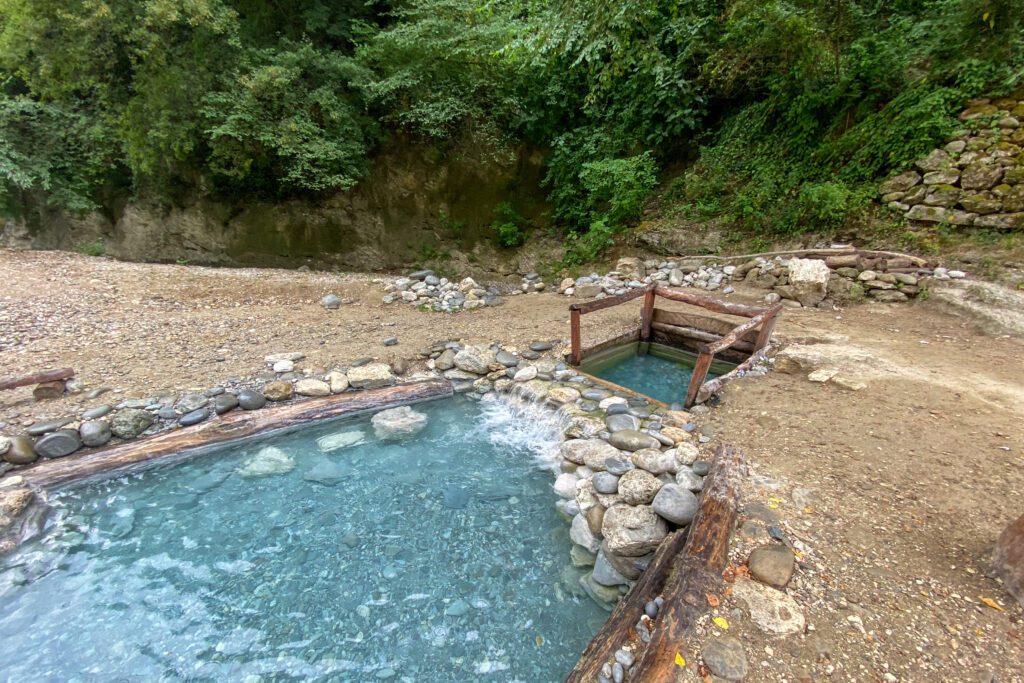
In this STAGE your eyes will enjoy numerous “wow points”! It begins with a fantastic natural setting, that of the picturesque Forcella waterfall, formed by the jump of the Rio Tallacano into the Tronto River. Nestled in this privileged place is the ancient Pompili Mill, dating back to the 12th century. Crossing the Tronto River, one arrives at the sulfur springs of Lu Vurghe in the hamlet of Santa Maria known since Roman times.
Its sulfurous, salsobromoiodic waters gush bluish at 38.6° at the bottom of a series of caves. The walk continues to the medieval village of Paggese, the little travertine Ascoli famous for its speaking stones (Latin inscriptions carved on the lintels of doors and windows). The church of San Lorenzo in the village’s main square is a treasure trove of art.
One passes through the village and shortly arrives at Castel di Luco, a unique fortified structure set on a travertine rise guarding the valley. Currently under restoration, it will once again be used for quality tourist accommodation in a historic home. We then travel along one of the mule tracks recently reopened as part of the Ancient Mule Trails of Acquasanta Terme project to arrive in the hamlet of Valledacqua and the nearby Abbey of San Benedetto in Valledacqua, founded by the Benedictine monks of Farfa Abbey.
Accommodations: Hotel Monastero Valledacqua, hotel 3 lanterne Cagnano di Acquasanta Terme
STAGE 06: Valledacqua – Coperso
Length: 17.9 km
Height difference: 640 m d+
This STAGE follows the path of the brigands. From the hamlet of Valledacqua you will reach the village of San Gregorio, at about 1,000 elevation where there was the headquarters of Brigante Piccioni, who in 1860 led the pro-Papal uprising against the Piedmontese in the Piceno hinterland who wanted to annex the Papal States to the nascent Italy.
The path continues toward Talvacchia with the Cammino dei BRIGANTI crossing the ridge separating the Tronto and Castellano valleys.
We are on the border between Marche and Abruzzo and note the characteristic V-shaped profile of the valley, surrounded by the Laga and Monti Gemelli mountain groups.
Accommodations: Fattoria La Cona Coperso, Country House Casale sul Lago, Bouquet and Gourmet (hamlet of Rosara)
STAGE 07: Coperso – Ascoli Piceno
Length: 16.7 km
Height difference: 620 m d+
We start from the locality La Cona di Coperso to take a dirt road downhill. We are in the valley of the Castellano River, skirting the course of the river until we reach the lake of Castel Trosino, a small village perched on a huge travertine boulder in a scenic position. From here, a dip back in time will take you to the famous Longobard necropolis, discovered in the late 19th century, at Santo Stefano. After a stop at Rifugio Paci for refreshment, continue to Colle San Marco and reach the Hermitage of San Marco, an ancient hermitage literally clinging to the rock face. It was chosen in the 13th century by Cistercian monks as an ideal site for meditation and contemplation.
From here we walk along the historical path that allows us to return directly to Ascoli Piceno, to the Porta Cartara neighborhood. Crossing the bridge of the same name and the Piazzarola neighborhood, we are back at the starting point: the wonderful Piazza del Popolo!
STAGE-BY-STAGE SERVICES
Are there supermarkets? Yes
Are there pharmacies? Yes
SIGNAGE
Present signage along the Grande Anello dei Borghi Ascolani
ROAD BOTTOM.
The road fund of Grande Anello dei Borghi Ascolani is as follows:
- 15%: asphalt
- 85%: dirt roads, trails and cart tracks
CREDENTIALS
Credentials present on the GABA, handed out upon arrival in Ascoli Piceno. Cost € 3.00 each.
TENT WALK
Where can one camp?
Venarotta ℅ space in front of municipal sports field; Ficocchia at Holiday House; Meschia sports field; Forcella private area granted upon request; Fornara of Acquasanta Terme; Talvacchia sports field
Are permits needed? Yes