
Via degli Abati
The Via degli Abati departs from Pavia, crosses the Po River and passes through Broni and then enters the Apennines of Piacenza, Parma and Tosco-Emiliano, (Bobbio, Farini, Bardi, Borgo Val di Taro) for a total of 190 kilometers arriving at Pontremoli (Ms), in Lunigiana, where it joins the Via Francigena of Sigeric.
The first part in Lombardy is flat and hilly while advancing to the Emilian part becomes more mountainous, in a wooded environment, very scenic and mainly on dirt paths. One often encounters small settlements, mountain villages and a few large towns with reception facilities and services. Some STAGES are served by rail and all by public transportation.
HISTORY
The Via degli Abati is an early medieval itinerary, from 600 to 1000, which the abbots and religious of the monastery of St. Columba of Bobbio (Pc), traveled to reach Rome. In the fall of 614, Columban founded the first nucleus of the future abbey of St. Columbanus in Bobbio.
The fertile area rich in natural resources proved to be an ideal location for a religious center by situating itself along an important axis of communication between northern Italy and the Roman papacy. As early as 862, the monks of Bobbio ran a hospital in Piacenza dedicated primarily to welcoming pilgrims, especially Irish, who came to Bobbio to visit the tomb of St. Columba. The Via degli Abati represented a pilgrimage route to Rome and to Bobbio and from there to Pavia, seat of the Lombard court.
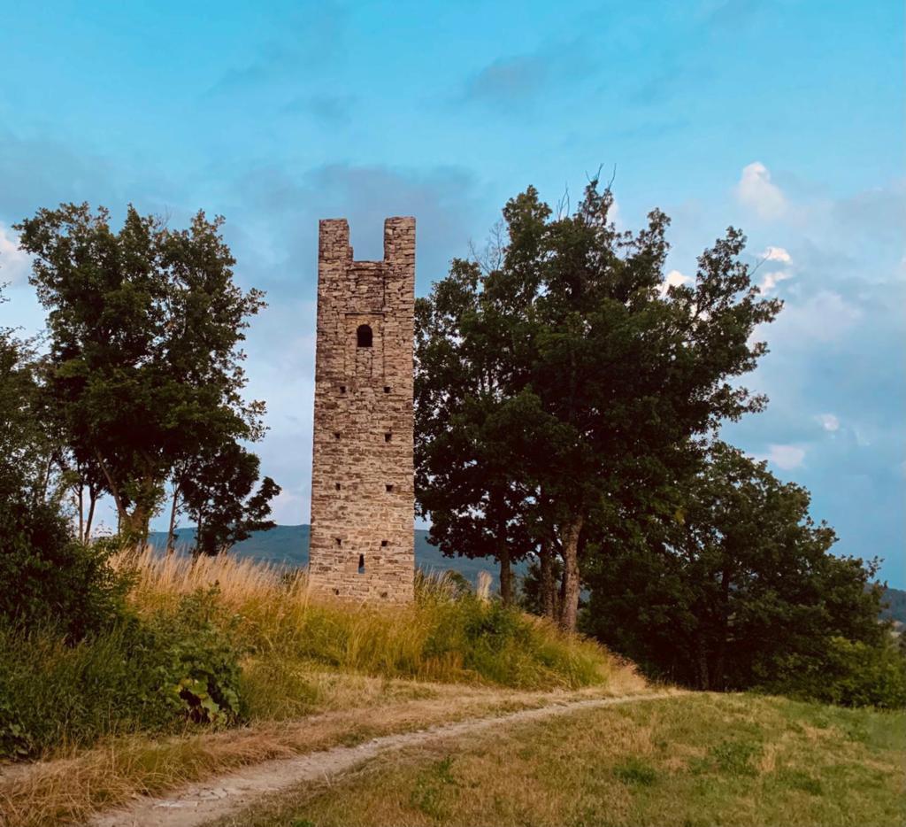
It was also an artery of communication between Lombardy and Tuscany fostering economic and political ties with passage of merchants, goods and devotees. Signs can still be seen today in the remains of towers, castles and other defensive architecture along the road. The ancient route, for the Bobbio-Pontremoli part, was rediscovered in the late 1990s by Giovanni Magistretti, a scholar from Piacenza and author of several reports on the Via. The research continued until 2007 with tests and route trials aimed at a trail running event that later took place back in 2008 and still exists today (The Abbots Way Ultratrail organized by the Lupi D’Appennino association).
WATER SOURCES.
Water points present at all crossings of settlements and villages.
STAGE
STAGE 1: FROM PAVIA TO COLOMBARONE Km 25.8 – Ascent m. 217 – Descent m. 36
Departing from the center of Pavia and leaving the city we cross the Ticino Park. Through dirt roads and farmsteads we cross the Po with the Becca Bridge and head toward Broni where we start climbing the hills to arrive at Colombarone (elevation 236 m.).
STAGE 2: FROM COLOMBARONE TO POMETO Km 16.7 – Ascent m. 649 – Descent m. 352
STAGE with travel on both paved and unpaved roads, passing through small mid-hill villages with mainly vineyard-oriented crops. Arrival in Pometo. (elevation 537 m.).
STAGE 3: FROM POMETO TO BOBBIO km 28.9 – Ascent m. 984 – Descent m. 1225
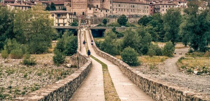
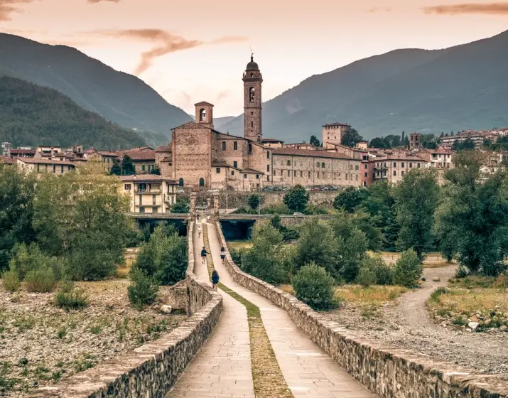
You leave Pometo descend to Caminata, cross the Tidone stream and then begin the ascent in a hilly and mountainous environment, on dirt tracks and paths encountering a few small villages. After the village of Grazzi you arrive at the Alpine Garden of Pietra Corva, a botanical garden with high-altitude plant species (not only alpine). Skirting Mount Penice and encountering ancient villages, you descend to Bobbio (Pc) (elevation 252 m.).
STAGE 4: FROM BOBBIO TO NICELLI 19.9 km – Elevation gain 1187+ – Descent m. 407-
From Bobbio you pass through Coli and then climb to Sella dei Generali, a watershed between the Trebbia and Nure valleys. From the pass, descend over mountain environment, meadows and trails to Nicelli (elevation 1050 m.) or Mareto (another possible STAGE point with reception facility).
STAGE 5: FROM NICELLI TO GROPPALLO 16.5 km – Elevation gain 542+ – Descent m. 659-
From Nicelli (or Mareto) we descend toward the Nure stream through small hillside villages connected by dirt roads or a few paved sections. Having reached the level of the stream, at Crocelobbia, we can choose to ford the stream or to lengthen the stage slightly by passing through the village of Farini. We then go up the opposite side of the valley to climb back to Groppallo (elevation 935 m.).
STAGE 6: FROM GROPPALLO TO BARDI 21.2 km – Elevation gain 557+ – Descent m. 857-
From Groppallo we pass through several small hamlets until we reach Bruzzi. After this locality we continue the path towards the Linguadà Pass (a more challenging variant is possible that climbs to Monte Lama and descends directly to Bardi). After the pass the route continues mostly downhill through small villages and reaches Bardi with a beautiful view of the castle and the valley floor of the Ceno stream.
STAGE 7: FROM BARDI TO BORGO VAL DI TARO 33.3 km – Elevation gain 1195+ – Descent m. 1410.
From Bardi descend to the bridge over the Ceno stream and climb the other side passing through small towns including Monastero, Brè, and Pieve di Gravago. After Osacca there remains the last uphill stretch to descend towards Val Taro and you begin to descend, still on dirt roads and paths, towards the valley floor and the town of Borgo Val di Taro (also called Borgotaro).
STAGE 8: FROM BORGO VAL DI TARO TO PONTREMOLI 33.9 km – Elevation gain 1029 – Descent m. 1080-
We leave the center of Borgotaro by crossing the bridge over the Taro stream and ascend toward S. Vincenzo and Valdena. From here by paths you climb toward the Borgallo Pass and the memorial stone placed on the very scenic ridge dividing Emilia-Romagna from Tuscany. By wide dirt road you descend gently into the Tuscan side towards the Farfarà waterfalls, Lake Verde, the village of Cervara and finally arrive at Pontremoli center.
SERVICES PRESENT STAGE BY STAGE
Are there supermarkets? Yes in the main villages, stores in the villages, hospitality facilities and bars – restaurants
Are there pharmacies? Yes in major countries.
SIGNAGE
The signage was redone in 2022.
DANGERS
There are no dangerous spots on the trail. Route suitable for good walkers, accustomed to dirt and wooded trails. The altitudes reached (about 1000 meters) do not make the temperatures particularly problematic, unless particularly bad weather.
ACCESSIBILITY
Only a few stretches on asphalt, more present in the Pavia – Bobbio section than in the following stages.
TENT WALK
Where can one camp? At public and private facilities
Permits needed? Need to contact municipalities or private individuals themselves. Free camping is not possible in all municipalities.
CREDENTIALS
There is the street credential, which can be picked up at the Pavia or Bobbio tourist office or can be requested directly from the association Via degli Abati after a liberal donation of 1 euro each credential + postage.
ROAD BOTTOM.
30% asphalt – 45% dirt – 25% trails


Via degli Abati
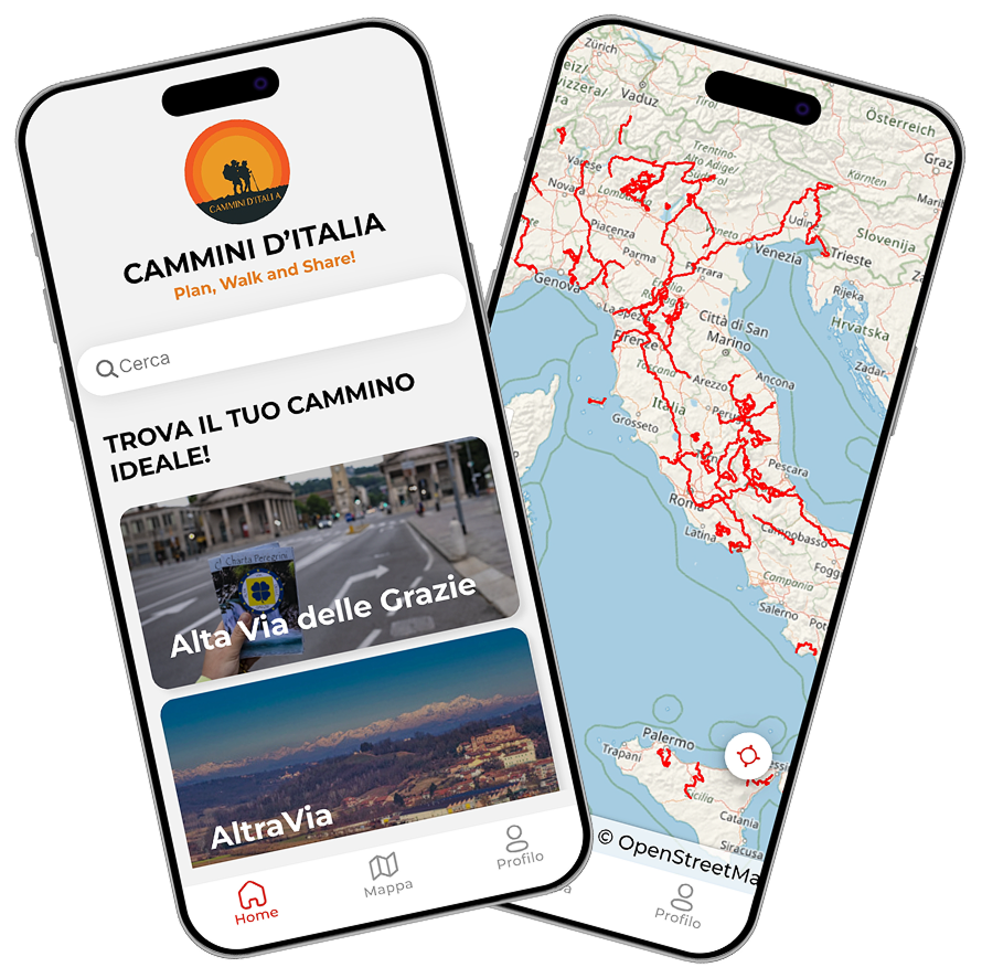
With the free Cammini d’Italia app, you can plan and walk the Via degli Abati safely, being able to plan the stages in detail and walk the route thanks to the built-in GPS technology that supports your orientation during your adventure.
⠀Inside the app you will find many other paths present in Italy. Thanks to the georeferenced tracks of many routes you will be able to study the itinerary that suits you best and also download the GPX tracks of the individual STAGEs offline.
The app also includes a complete digital map of all the paths surveyed to date on our portal, giving you a wide range of choices among the many paths in the Belpaese.
⠀⠀
Cammini d’Italia is the perfect app for those who want to explore the beauty of Italy on foot, discovering hidden places surrounded by nature. Download it for free today and start planning your next adventure!
⠀
⠀
 ⠀⠀⠀
⠀⠀⠀