
Via Marialonga
Via Marialonga is a historical/hiking path that starting from Fornovo Taro in the province of Parma, reaches after crossing the Apennines, Sestri Levante in the province of Genoa, crossing 2 regions, 4 provinces and 15 municipalities traveling along ancient roads of considerable environmental value passing through ancient villages where time has stood still.
The 144-km-long hiking route, challenging but highly satisfying, seeks where possible to retrace the historic and original routes and partly assumed where no trace of them could be found.
Those expecting to find at Via Marialonga a proven and served path on par with many “organized” and more “touristy” routes will be disappointed.
Although the path arrives at the end of each STAGE in countries provided, it often passes through places that may appear abandoned and where directions, however controlled, may be meager.
Therefore, those who expect to find in Via Marialonga a (sometimes) “mountain” path, an adventurous one that needs a fair amount of experience and physical preparation, will be fully satisfied.
HISTORY
Segesta Tigulliorum (present-day Sestri) in Roman times was a very important trading port of the Empire.
It was precisely from Segesta that a vital direct route to the municipality of Veleia Romana departed via the Hundred Crosses Pass.
The road crossed into the territory of present-day Piacenza through the Pellizzone Pass . It is at this point that it grafted Via Marialonga:
a ridge road directed to Forum Novum (present-day Fornovo Taro) also an important Roman town.
A road that connected the most important Roman municipalities, facilitating the exchange of goods from the sea in the days of the empire and later used by pilgrims heading to Rome as a junction between the “Via dei Monasteri Regi” and the “Via Romea di Bardone” (later named “Via Francigena”) as evidenced by the 1300s jubilee stone found near the castle of Rocha Leone (Roccalanzona)
WATER SOURCES.
There are several fountains and water points along the way ( villages or near cemeteries) but the drought of recent years very often tends to dry up the springs, so it is a good idea to refuel at the start of each STAGE.
STAGE
STAGE 1:
Fornovo Taro (Fornóv in Parmesan dialect; 5900 inhabitants; 158 mt asl)
Pellegrino Parmense (Pelegrén in Parmesan dialect; 1000 inhabitants; 410 mt
asl)
17.9 Km -400 mt +670 mt
Water points on the route: at the Mariano cemetery about 15 km from the
start.
After Ramiola, no villages are crossed and therefore no
commercial activities of any kind are encountered.
Fornovo Taro is an important commercial center located at the beginning of the
Taro Valley.
It is a town stocked with several businesses where pilgrims can
safely stock up on all kinds of supplies before embarking on the journey.
The first STAGE retraces entirely the historic route of which it is possible
still to admire the layout
The walk starts from the churchyard in front of the Romanesque parish church Santa Maria Assunta in Fornovo Taro.
It quickly crosses the historic center of the village and then
crosses the Taro River.
Just from the bridge it is already possible to notice, looking to the left, the track of Via Marialonga that climbs the opposite coast.
Having crossed the bridge, one arrives in the village of Ramiola and near a traffic circle (presence of a supermarket and bar) one needs to head left in the direction of Varano Melegari.
After about 500 m, leave the paved road and
take the wrongly identified “Maria Lunga” road on the right, at the sign of the built-up area “Boschi
di Viazzano”.
Via Marialonga immediately gains altitude with a challenging and bumpy section of trail but quickly giving interesting views.
The Via becomes a ridge road (Cai trail marker 802) with quiet
ups and downs, and it will be enough to follow the beaten path without any particular noteworthy indications, ignoring the numerous driveways that descend transversely into the valley;
we would thus have plenty of time to observe the splendid panorama: on one side the Taro and Ceno valleys and on the other the narrower, greener Val Dordone.
Behind is observable the entire Po Valley beyond which, on clear days, much of the Alpine arc can be seen.
Ahead of us, the Apennines begin to take shape and its presence will accompany us throughout the
stage.
The ancient Via quickly reaches the ruins of the Castle of Roccalanzona (ancient Rocha Leone) now privately owned and then reaches the characteristic ophiolite of Pietra Corva from which it is possible to observe a breathtaking 360° panorama
Via Marialonga gently runs along the ridge until it reaches the provincial road SP30. It is necessary to take a right and walk along a short stretch of asphalt road until taking the path on the right the Cai 824 path to reach the ancient village of Mariano (mentioned as a pagus in the Trajan Tabula Alimentaria,
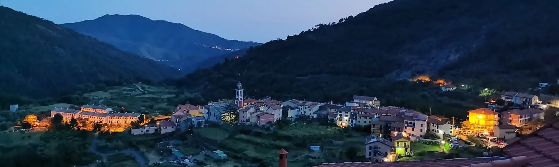
bronze inscription found in Veleia dated 2nd century AD) and then continue along the mentioned path, crossing the locality Cà Passeri to then reach the village of Pellegrino Parmense, the end of the STAGE.
STAGE 2:
Pellegrino Parmense (Pelegrén in Parmesan dialect; 1000 inhabitants; 410 mt
slm)
Bore (Bòri In Parmesan dialect; 655 inhabitants; 835 mt slm)
19.6 km -370 mt +800 mt
Water points on the route: Church of Pozzolo, Pozzolo Cemetery, entrance to
Bore.
During the STAGE we pass through small villages with no commercial activities.
Only in Pozzolo is there a bar pizzeria.
Pellegrino P.se is an averagely stocked town with several businesses
where the wayfarer can safely stock up on basic necessities.
along the STAGE one encounters only one inn, pizzeria in loc. Pozzolo (at
about 15 km from the start).
The second STAGE of Via Marialonga is characterized by wide views of
considerable interest and passes through villages where there is evidence of the presence of
pilgrims along the way.
It takes place for long stretches on asphalt country roads, alternating with gentle and
prolonged shaded cart tracks.
Starting from the center of Pellegrino, it runs along a short stretch of almost
flat asphalt road in the direction of the village cemetery (Cai trail 820) to
take the path marked as 820 on the left and immediately afterwards keep
left to continue on Cai trail 822 in the direction of Besozzola. The trail,
at first gravel becomes dirt, gently crosses shady
and cool mixed woods typical of the mid-hills. Just before the hamlet of
Besozzola, at a post on which the house number
75 is indicated, take the small asphalt road on the left that leads sharply downhill back to the road
joining Pellegrino with the hamlet of Aione. Continue
briefly to a crossroads located at the Egola mill
(TF marker) where it is necessary to take a right turn in the direction of the small hamlet of
Iggio.
It is always traveled on asphalt (about 3 km) arriving at the characteristic and
very old village of Iggio.
In front of the small church dedicated to St. Martin the Bishop, the continuation of the path, representing the remains of the ancient
road, can be seen among the houses
made of stone.
On a gentle, short climb, we reach the paved country road that
we have to travel (in the left direction) without much care given the low
traffic (ISFB markings).
On this section of the trail, which can be considered trivial, you can observe a
beautiful panorama, both in front of us, and behind us, where you can see
beyond the Po Valley, much of the Alpine arc
After 1.5 km, you must take the right path that, with AVC marker in
direction Castiglione dei Turchi, leads us to cross a cultivated area. At the
first fork, near a crossroads of cart tracks, take the steep path
right and ,after 100 m, immediately left. The wide and easy carraia
shaded with often wet bottom, leads to the hamlet of Silva
crossing centuries-old chestnut groves. In quick succession, after passing through the hamlet of Villa Zacchi, you reach the historic hamlet of Pozzolo
recognizable by the ophiolitic presence of the Rocca di Pozzolo on which is erected the
little church of the village dedicated to San Maurizio Martire with the characteristic
underlying hamlet of Villa Conti.
It is advisable to deviate briefly from the marked path, for a fleeting as
as exciting visit to the Churchyard and the dizzyingly deprived, to reach
the Cross erected on top of the ophiolite from which one
of the most beautiful views of the entire STAGE can be observed.
Leaving the blockhouse, just above the cemetery, it is necessary to take a left turn and
continue straight ahead, still on a driveway.
After crossing the small paved road coming up from the village, continue in
climb along the beautiful and easy gravel road that local people “the
cavalèra” as a reminder that in times past it was traveled by pilgrims and horses:
along the route at certain points the ancient pavement is clearly visible, which continues
steadily uphill, always in the shade, through beautiful chestnut woods ,
until it reaches the SP4 Bore – Vernasca road just downstream from the crossroads
of Case Luneto.
You have to take a left and continue a short stretch of asphalt and then
the gravel path that runs alongside the road and then reach after about 2
km the village of Bore, the end of the STAGE.
STAGE 3:
Bore (Bòri In Parmesan dialect; 655 inhabitants; 835 mt asl)
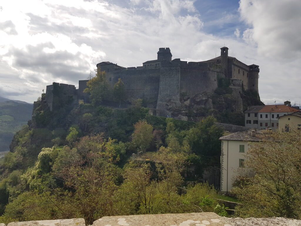
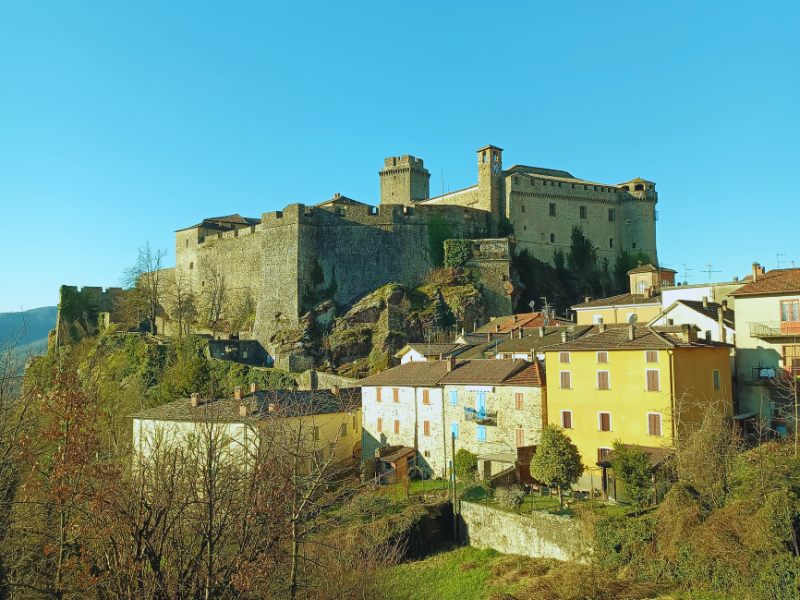
Bardi (Bèrdi In Parmesan dialect; 2000 inhabitants; 625 mt asl)
16.6 km -740 mt +520 mt
Water points on the route: Fonte San Giovanni 10 km from the start; cemetery
of Bardi on the outskirts of the town.
Along the STAGE, no towns are crossed. A bar-restaurant is encountered on the Pellizzone Pass.
Bore is an averagely stocked village with several businesses where the
wayfarer can easily stock up on basic necessities.
Leaving the town of Bore we head on asphalt for 1.5 km toward
Bocchetta delle Sette Sorelle on SP 359 R , when , after 200 m we take at
Sx the Cai AVC trail (Ceno valley ring) we head toward the Pellizzone pass strategic crossing point between the provinces of Parma and Piacenza
touching the slopes of Mount Carameto.
The beautiful and long cartroad climbs with almost constant gradient among
shady chestnut and beech forests making the tiring
ascent to the pass pleasant and fresh. It is necessary to pay particular attention to the signs
so as not to easily get the path wrong, helping yourself strongly with the track
GPS.
You slowly reach the crossroads towards Mount Caramento, marked by
Cai pole with path 801. One must keep right always on AVC trail
to reach after a short descent to Pellizzone Pass.
While the ascent takes place almost entirely in the woods leaving few spaces
open, the descent, on the contrary leaves the possibility to admire the wide valley
of the Ceno Valley with the unmistakable Pizzo d’oca while, in the distance, it is
possible to see the imposing silhouette of the Bardi fortress.
On the Piacenza side, however, the Groppo di Gora ophiolite,
Mount Lama and Mount Menegosa are distinguishable.
Immediately after the pass, it is possible to take the path to the left that will allow us to
avoid 2 hairpin bends of the provincial road and continue, immediately afterwards on path
Cai 801A towards Bardi.
After about 800 meters at an asphalt road, it is advisable
to travel backwards along a short stretch of gravel road to reach the
cool fountain of Fonte San Giovanni and immediately afterwards the characteristic
little chapel dedicated to the same saint.
Rapidly downhill, we re-encounter the paved lane that we will abandon
immediately after to take a right onto a path that takes us in quick but pleasant
descent to meet SP 359 R, which we will have to travel for 2 km (in
near a picnic area there is a cool drinking fountain) until we reach
the town of Bardi, the end of the STAGE, characterized by the imposing
fortress overlooking the Ceno valley and home to important
businesses where the Via Marialonga pilgrim can refresh and
relax.
STAGE 4:
Bardi (Bèrdi In Parmesan dialect; 2000 inhabitants; 625 mt asl)
Compiano (Cùmpiàn In Parmesan dialect; 1000 inhabitants; 520 mt asl)
Bardi – Compiano
20.2 km -650 mt +630 mt
Water points on the route: at Beata Vergine di Pompei church at 1 km from
departure; junction for Monte Pelpi 500 mt after Colla Pass
Along the STAGE no towns are crossed and therefore no
commercial activities of any kind are encountered.
Bardi is a town well stocked with several businesses where the wayfarer
can safely stock up on essentials.
Challenging STAGE in the uphill stretch to the Colla Pass.
It takes place for long stretches on asphalt country roads, alternating with gentle and
prolonged cart tracks along the Toncino stream.
Leaving the village of Bardi, follow the path of Via degli Abati to the
crossroads of Ponteceno, which descends steeply past the characteristic Oratory dedicated to the Blessed Virgin of Pompeii. After crossing the road you
go down again until you reach the bridge over the Ceno stream at
which, turn right onto the small road that runs parallel to the stream to
cross it at the Mulino dei Belli.
In this short stretch, you need to pay particular attention to the markings
so as not to get it wrong easily, path, helping yourself strongly with the GPS track
since you will be traveling along paths sometimes hidden by thick vegetation and of
difficult to locate
You climb for a good part on asphalt road parallel to the Toncino creek.
After about 3 km, take the small road to the left in the direction of the “ghost” village
of Scappini houses known as “the village of crying children.”
The wide gravel road, which climbs easily, is maintained.
After 1.5 km the road stops and it is necessary to continue along the steep
path that climbs flanking the methane pipeline poles.
The first climb gives way to a short flat stretch and then
resume VERY sharply (thankfully short) before reaching
the paved road that quickly leads us to the Colla Pass (1000 mt) .
The most challenging part of the STAGE is over, and the long descent, not
particularly challenging, alternating paved and graveled sections, that
leads us to the village of Compiano leaves us time to observe the surrounding panorama
; Mount Pelpi on our right and further on Mount Penna and Ragola ,
the Maggiorasca and Mount Bue. Clearly visible in front of us are the shovels that
identify the Passo del Cento Croci, which we will cross on the next STAGE.
We travel a long stretch on asphalt until we reach the fork to Sambuceto. We take
then to the right and at the next fork again to the right going along an easy
gravel road until we meet, on the right, a Votive Chapel.
Taking then to the left, we travel along the old road, reduced to wide gravel,
to the entrance of a dwelling. Avoiding crossing the prohibition, we
head left continuing to descend steeply until we meet the
road abandoned previously to avoid entering the private area.
We need to head left and keep on the track until we meet
after a short time the asphalt road SP66 that descends from the Colla Pass,
We need to take a right and travel on asphalt the last 2.5 km crossing
the village of Costa, to reach Compiano, the end of the STAGE.
STAGE 5:
Compiano (Cumpiàn In Parmesan dialect; 1,000 inhabitants; 520 mt asl)
Varese ligure (vai]ze in Ligurian dialect; 1,800 inhabitants; 355 mt asl)
28.2 km -1120 mt +960 mt
Water points on the route: cemetery of Tarsogno at the entrance to the village; fountain
at the exit of Tarsogno; Pratolungo refuge; Chiapparino Pass; downhill
averso Varese Ligure.
Along the STAGE we pass through the village of Tarsogno where there are several
businesses.
On the One Hundred Crosses Pass (100 mt on the Ligurian side) there is a bar restaurant.
Compiano is a town averagely stocked with several businesses where
the wayfarer can safely stock up on basic necessities.
along the STAGE meets the village of Tarsogno where there are a few businesses
commercial activities.
The fifth STAGE takes us out of the province of Parma and into
that of La Spezia.
The path begins to be challenging, taking us over one of the most
characteristic passes of the Ligurian-Parmine Apennines, although defaced in part by
numerous wind turbines.
Leaving the characteristic Compiano behind us, on the left a footpath
allows us to avoid two asphalt hairpin bends and quickly leads us to
below SP359. Having crossed the road, we need to take a right and soon after,
left, cross the Taro River on a characteristic pedestrian bridge. Proceed
without detour through the village of Isola di Compiano, and in
correspondence of the cemetery of the hamlet, you need to head left.
The beautiful and wide carriageway, takes gently of altitude, shaded by oaks
alternating with chestnut trees.
Crossed the narrow asphalt road, you follow it taking the right in
direction Marzuola until you take the path Cai 823A on the left towards
Tarsogno.
Along the cart track, which soon becomes a shady path, is a
water fountain and later reaches the historic remains of the ancient
hamlet “I Chiodi,” where the ruins, partly covered by vegetation, leave
glimpses of long abandoned dwellings. It is necessary to take right
and continue always on the path CAI823A, in gentle ups and downs along the small gravel road
to reach the Provincial Road of Centocroci hill in
correspondence of the cemetery of Tarsogno.
It is advisable to take the paved road to cross the village of
Tarsogno, where there are various businesses and commercial activities.
Leaving, from the hamlet, after a water point, take the small road on the right
(CAI853), which soon becomes a wide driveway among centuries-old chestnut trees.
We are in the home of porcini mushrooms, so, it is not difficult, to the attentive eye,
to find some along the trail as well.
Without too much attention, follow the well-marked trail. up to the area
refreshment of Pratolungo where you can find another water point.
You have to take a left and keep the gravel road that bypasses a small central
meets the Centocroci Hill Provincial Road.
The Pass is now close, so taking a right take the few hairpin bends
that in less than 2 km bring us to the border of the province of the region Liguria
and Emilia R.
From the pass it is possible to admire the surrounding mountains, although some of them
(especially on the Emilia side) disfigured by the numerous wind turbines.
One is completely surrounded by the major reliefs that make up this
stretch of the Apennines.
Just from the Centocroci Pass, taking a right turn we travel without major
problems and difficulties a long stretch of the Alta Via dei Monti Liguri: wide
scenic trail alternating with shaded by beech forests characteristic
of the northern Apennines.
Along the way it is easy to spot wild saffron flowers.
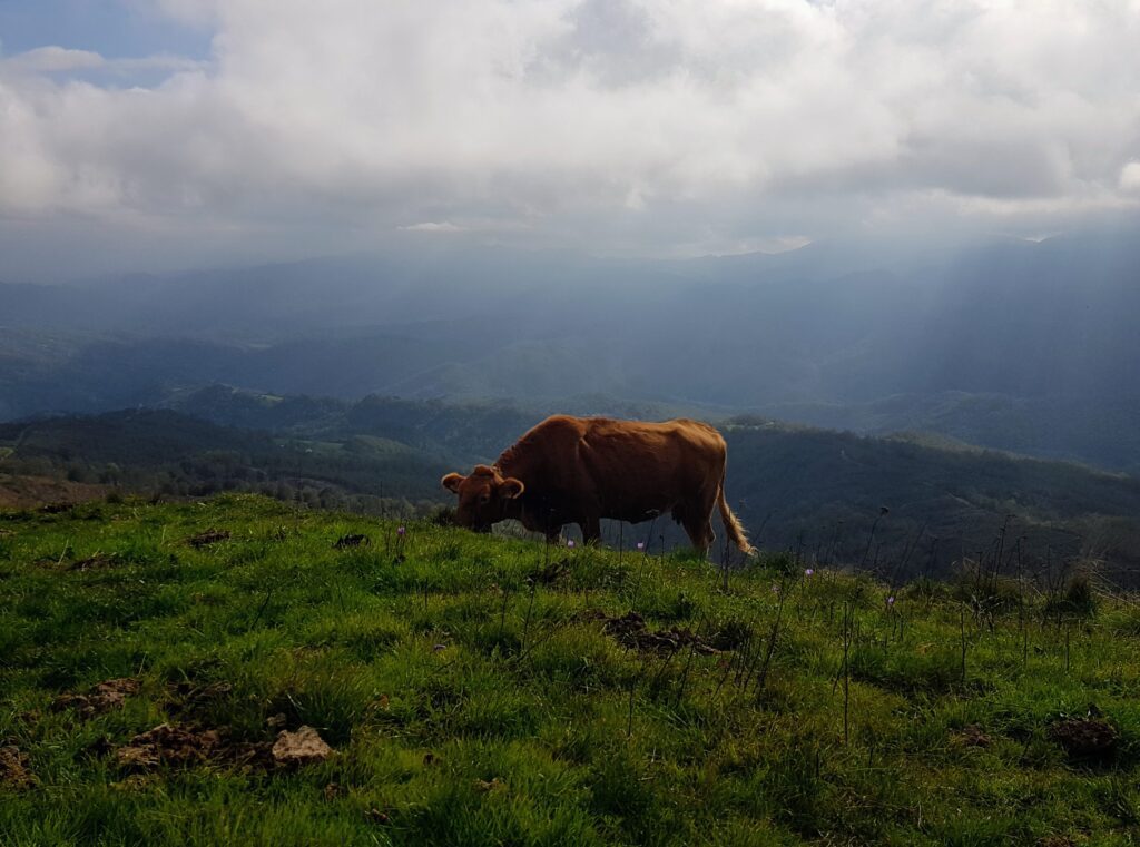
From the summit Mount Ventarola (1177 mt, the highest point of the STAGE) we
descend through green mountain pastures where, horses and cows grazing,
provide characteristic bucolic views.
We continue with no chance of failure along the wide cartroad to
reach Chiapparino Pass (water point) where we leave the
Ligurian/Emilian ridge.
Taking towards the left the Cai 811 trail (more water points in succession) in
a short time you will reach the quaint town of Varese Ligure, the end
of the tiring and long STAGE.
STAGE 6:
Varese ligure (vai]ze in Ligurian dialect; 1,800 inhabitants; 355 mt asl)
Bargone (900 mt asl)
28 km -951 mt +901 mt
Water points on the route: absent
Along the STAGE, no towns are crossed and therefore no businesses of any kind are
encountered.
Varese Ligure is a town well stocked with various businesses where the
wayfarer can easily stock up on basic necessities.
The sixth STAGE, as challenging as it is particularly scenic, takes us
through evocative stretches of the Ligurian Apennines, giving the more daring the chance to climb Mount Porcile, which at 1249 meters turns out to be the
highest point of the entire Cammino.
The STAGE essentially travels along trails and cart tracks mostly
used by ancient peoples to connect Liguria with
Emilia and therefore also taken up by the present hiking route.
Leaving Varese ligure behind, we head on the asphalt road of
Cento Croci in the direction of San Pietro Di Vara and then take, after the bridge over the
Fiume Vara, a right turn in the direction of Passo del Biscia, the CAI path 601.
At first paved, the small road, after a few hairpin bends lined with beautiful
hazelnut groves, enters the forest.
Continue through the dense chestnut forest, keeping always on CAI trail
601 in the direction of La Villa / Valletti, when near the hamlet of
Colla, a detailed marker indicates us to go left in the direction of Colli di
Valletti.
The trail starts gently uphill and then becomes paved before
entering the largely abandoned hamlet of Colle di Salvetti.
On the left, the panorama gives us our first glimpses of the Tyrrhenian Sea, in the distance the
Apuan Alps and in front Mount Porcile, which we will face shortly. Arriving at
a crossroads, we stay on asphalt on CAI 610 trail marker until we meet on
dx a forest road bordered by a bar. We continue on this road until
we meet a second gate beyond which we need to keep
on the left.
The beautiful forest road that runs on a constant slope with wide
hairpin bends lined with heather shrubs leads us to admire very
suggestive views. Near a bend, a bench with a table gives
the opportunity to catch one’s breath while observing one of the most interesting views of the entire
path.
Quickly, on a forest road that continues with gentle ups and downs, we arrive
near the converging point of paths of Fontana Sagrata, stingy with
indications.
At this point, the more daring and less tired can climb up the path in front
to reach the summit of Monte Porcile, the highest elevation of the entire route
whose summit affords truly unique and unforgettable views of everything
the Ligurian Apennines, the Ligurian Sea to, on clear days, Corsica. Once the summit is reached, the narrow winding path quickly reaches
the Broccheie Pass.
It is possible to avoid on Porcile Mountain, taking the less scenic
path to the right that threads its way through the beech trees, heading towards Biscia Pass, which gently
crosses the Forest Road (CAI AV5T marker).
Take a left and continue on wide road that quickly reaches The Pass
Broccheie.
Keeping to the scenic cartroad lined in places with pine trees
mughi, we reach the Arena Pass and after a short while, on a gentle descent, the
Pass of Bocco di Bargone.
Bocco di Bargone Pass is an attractive and scenic crossroads.
It is necessary to continue in the left direction and drive along the wide gravel road
marked as AV5T that gently descends flanking Mt. Zeno .
After about 800 m, take a right onto the consortium road that descends towards
Costa di Bargone / Bargone which, amidst wide panoramic views of the Gulf of Sestri
and crossing fresh Mediterranean scrubland, makes it possible to reach
comfortably and defatically, in about 90 min, the hamlet of Costa
where there are a couple of lodgings and immediately afterwards the Borgo
Medievale di Bargone, the end of the STAGE.
Descending from the Bocco Pass, several paths are crossed that “cut”
consistently the wide and comfortable consortium road previously
illustrated. It is not recommended to travel these stretches (by mtb it is practically
impossible) often closed by thick vegetation and due to the presence of the bottom
very uneven making the paths challenging and difficult.
Therefore, assess well your physical condition.
Reached the hamlet of Costa, to get to Bargone, if you travel Via
Marialonga by mtb, it is recommended to avoid the short stretch of path that descends
into the road below, which is instead pleasant if traveled on foot.
STAGE 7:
Bargone (900 mt asl)
Sestri Levante (Sestri Levante in Ligurian dialect; 17500 inhabitants; 10 mt asl)
13.3 km -800 mt +500 mt
Water points on the route: Cemetery church of San Lorenzo after Casarza L.
Along the STAGE we pass through the town of Casarza Ligure where there are
several businesses.
Last stage with the scent of the sea.
Deliberately short stage to give the pilgrim the opportunity to deserve, after
the tiring and long route, a refreshing relaxing day.
The presence along the stretch of numerous steps and the crossing of
numerous sassaias, make this last STAGE very difficult to tackle
by mtb therefore it is recommended to reach Casarza and then Sestri
Levante along the asphalt road and then the bike path that
allow you to reach the seafront of the Ligurian town.
Leaving the medieval village of Bargone, we head, on asphalt, for a few
hundred meters in the direction of Casarza, when, on the right, a
path is clearly visible (well marked by red triangular markers with a square
white background) with a sign indicating the latter locality. With a few
steps it gains a little elevation and then maintains itself, through a comfortable
and panoramic path among low juniper and sparse maritime pine woods, little
shaded at an almost constant level. After passing the relief of
“Monte della Mora” (360 s.l.m.), the trail descends gently to reach
the main town of Casarza Ligure.
The itinerary plans to go around the center of the Ligurian municipality (important
follow the .gpx directions) but a visit is still recommended before
resuming the route.
We climb sharply, in the direction of Bruschi to reach the small church
of San Lorenzo. At a hairpin bend, take the left-hand path that
takes us quickly near the Sestri highway exit.
At this point the landscape is heavily man-made and the pilgrim can
decide whether to abandon the recommended trail to reach through the
numerous streets, the center of Sestri or continue on the recommended route to
discover one of the most striking views of the coastline.
The trail is definitely challenging, although short, but since it represents
the last effort of the walk, we recommend continuing.
Therefore it will be necessary to continue in the direction of the sanctuary Nostra Signora del
Soccorso to reach, along a landscape of considerable botanical interest,
the Saracen Tower of Punta Manara and the “telegraph” located on a breathtaking promontory
between Riva Trigoso and Sestri where it is worth pausing to admire
the panorama. It will then suffice to take the path to the right that in a short
walk along the coast will lead us into picturesque Sestri through the Vicolo
Dei Bottoni.
Reaching the pedestrian island, we head left to reach the
waterfront end of the STAGE and end of the walk.
SERVICES PRESENT STAGE BY STAGE
The arrival of each STAGE takes place in towns that are all provided with basic necessity stores.
Pharmacies are present in all end-of-stage countries.
Each village is served by public transportation that can take the pilgrim to the starting point just in case.
SIGNAGE
Via Marialonga Is a “green” pathway. Environmentally conscious. Therefore, it was deemed inappropriate to fill the Way with unnecessary sticky arrows or daubed with paint roadways and trees, except the bare minimum.
With a simple cell phone, it is possible to download the entire trail in .gpx format that is always up-to-date and safe from vandalistic manipulation.
You will then find, along the way, few arrows and directions.
To avoid mistakes, it is highly recommended to follow the GPS track of the walk.
In many sections of the route it is essential to follow the .gpx tracks downloadable from www.viamarialonga.com, which are continuously updated, to avoid having to deal with sections of considerable difficulty or even worse getting lost.
DANGERS
No dangers of any kind are encountered along the way.
ACCESSIBILITY
Like so many trails , both hill and especially mountain trails, the Via Marialonga path unfortunately cannot be walked by people with a severe motor disability.
ROAD BOTTOM.
About 30 % asphalt
About 70 % trail, cart tracks


Journey diaries
Via Marialonga
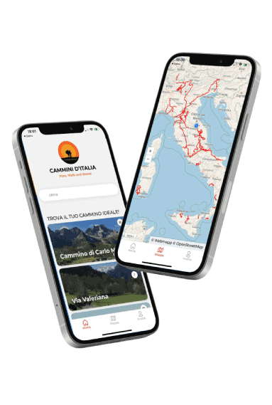
With the free Cammini d’Italia app, you can plan and walk the Via Marialonga safely, being able to plan the stages in detail and walk the route thanks to the built-in GPS technology that supports your orientation during your adventure.
⠀Inside the app you will find many other paths present in Italy. Thanks to the georeferenced tracks of many routes you will be able to study the itinerary that suits you best and also download the GPX tracks of the individual STAGEs offline.
The app also includes a complete digital map of all the paths surveyed to date on our portal, giving you a wide range of choices among the many paths in the Belpaese.
⠀⠀
Cammini d’Italia is the perfect app for those who want to explore the beauty of Italy on foot, discovering hidden places surrounded by nature. Download it for free today and start planning your next adventure!
⠀
⠀
 ⠀⠀⠀
⠀⠀⠀