
CAMMINO DELLA PIETRA BIANCA
A loop walk between the Amerini Mountains and the Tiber River, on dirt roads with a characteristic clear white crushed stone bottom. Along the way we pass through charming villages, a perfect itinerary for those seeking history, nature and enchanting landscapes of Umbria.
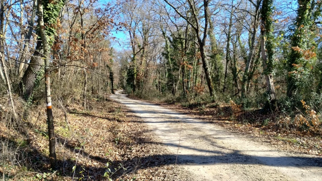
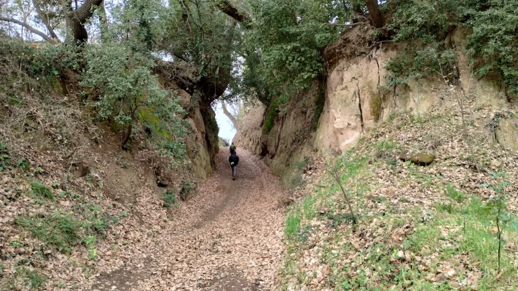
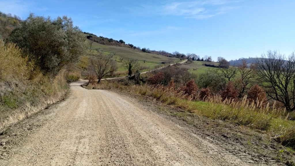
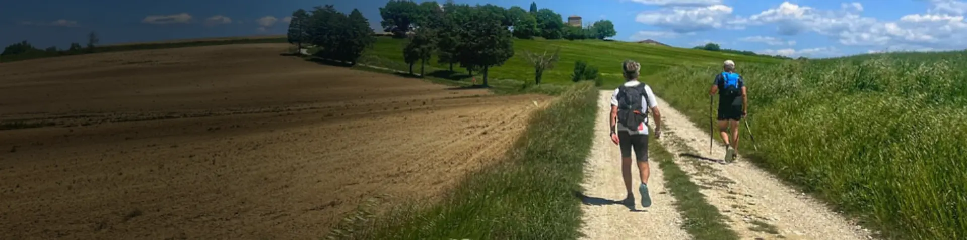
The CAMMINO DELLA PIETRA BIANCA is a 126-kilometer loop trail that winds through the territories of the Amerini Mountains and the Tiber river area. Its uniqueness lies in the bottom: almost the entire route is on dirt roads covered with a characteristic white crushed stone, a typical material of the area, used to make the roadbed more stable.
The route is divided into six main STAGES, which can be broken down into fourteen sections of varying lengths, connecting as many villages. This modular structure allows you to plan the walk according to your own pace and needs.
HISTORY
CAMMINO DELLA PIETRA BIANCA stems from the writer’s previous experience in practicing and organizing events related to the world of Trail Running.
Around 2010 Trail Running saw considerable participation by a user base driven, more than by the competitive aspect, by experiencing the sport in nature and on particularly visually engaging trails.
Slowly the idea of uniting the villages that hosted the various events with one big trail took shape. However, we had to find the subject that could be at least ideally representative of the connection between the hamlets.
From the study of the history of the villages, it was noted that the name of St. Francis appeared in most of the sites: monasteries, churches, chapels, and mirrors named after the saint, due to his passage or miracles performed, prompted the name of the Trail that united all the villages on the ridge of the Amerino mountains, TRAIL OF THE WAYS OF SAN FRANCESCO.
Thus was born a 6-edition experience of the Via di Francesco ultra trail, which over the course of the various editions reached 200 km in length.
The idea of the transformation from a competitive route to a Camino was born from the statements of the vast majority of the participants: IT IS A BEAUTIFUL JOURNEY. This was asserted by the participants upon arrival, who were impressed by the views, the serenity of the landscape, the welcome of the inhabitants of the villages they passed through, and above all by the empathy that the whole apparatus conveyed.
Running thus became Cammino, the slowness or rather the unhurriedness to arrive but to spend one’s time in the practice of walking, prompted the transformation of Trail, which still means track, path, into Cammino.
The name Pietra Bianca comes from the use of the limestone typical of the area for the construction of towers, farmhouses, bridges, dry stone walls, and for the construction of the white roads on which the walk is mainly developed.
From 2023, therefore, the adventure of the Cammino della Pietra BIANCA begins with the study of the trail, contacts with municipal administrations, pro-loco, cultural and sports associations, historical research, and the involvement of all the figures that make a trail a Path, first and foremost THE WALKERS.
SIGNAGE
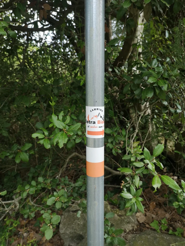
The entire route is marked with orange-white markers.
WATER
The departure of each of the 14 routes is from a hamlet, where there are bars and markets; in addition, “Water Houses” are also available in the municipalities.
Several drinking fountains are encountered along the route, which until recently were commonly used. Today they all bear the indication “non-potable water” and therefore cannot be considered as water sources.
Editor’s note: Water houses, supermarkets and pharmacies are being mapped. Data will be updated as soon as available.
IN TENT
There are currently no equipped camping areas in the vicinity of the Walk. Some municipalities are equipping themselves; updates are awaited
CREDENTIAL
The Credential must be requested on the site or picked up at the start. It is provided free of charge, but the walker is encouraged to leave a voluntary contribution to help maintain the trail.
ROAD BOTTOM.
Most of the route consists of dirt roads and cart tracks, with a few stretches of footpath. Near towns and crossing villages, the surface is asphalt. In total, the Cammino has 35 km of asphalt over 126 km, with a percentage of asphalt less than 28 percent.
CONTACTS
CONTACT DETAILS FOR THE WALK:
Web site: www.camminopietrabianca.it
E-mail: info@camminopietrabianca.it
Facebook: CAMMINO DELLA PIETRA BIANCA
Instagram: thecamminodellapietrabianca
TikTok: white walk.
+39 3403303437
ASSOCIATION DATA:
APS Panta rhei
Social Promotion Association – Headquarters: 05012 Attigliano (TR), Piazza Vittorio Emanuele II No. 2
e-mail: pantarheiac@gmail.com – Pec: acpantarhei@pec.it
STAGE 01
STAGE 01: Attigliano to Penna in Teverina
Length: 21 km
Height difference: +854 m / -641 m
After visiting the historic center of Attigliano, with its glimpse of the valley below and the alleyways overlooked by the village’s ancient buildings, we start from Piazza Vittorio Emanuele.
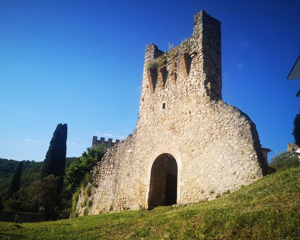
After passing through the village of Attigliano, take the dirt road that climbs the coppice of the Bandita, until it leads to the Jupiter lookout and the village gate located below the Ducal Palace.
Having passed through the historic center of Jupiter, proceed to Penna in Teverina by walking along a section of the existing Cammino di San Valentino, then descend to the Strada della Barca, where there is the ancient Casale della Barca and the bridge of the same name, whose name derives from the ancient landing place that allowed the crossing of the Tiber River below.
Having reached the vicinity of the village of Penna in Teverina, we descend until we reach the Solfatara, and then climb back up to the new part of the village. Skirting the built-up area, you return to the western side to cross the ancient gate, from which there is an enchanting view, which allows you to cross the charming old town.
STAGE 02
STAGE 02: from Penna in Teverina to Sambucetole
Length: 19.2 km
Height difference: +608m / -584m
A visit to the neat little historic center of the village of Penna in Teverina is a must, as is a visit to the church and the historic stable nativity scene.
Leaving the built-up area and travelling along a section of the provincial road, we cross the Piano delle Selve and skirting the Podere di Monte Pelato we arrive at the Spiccalonto road that will lead us to Amelia.
Amelia welcomes us with its door, inside which it is possible to visit the church of St. Francis.
It continues alongside the characteristic cyclopean walls, descending toward the Rio Grande Park and through the Pisciarello vocabolo, the Podere Monte Piglio and the Podere Angeletti, to arrive in the vicinity of the Cappuccini Cave and the monastery of the same name.
The climb to the aqueduct plant is a bit steep and rocky, as is the descent to the village of Sambucetole, which is reached after crossing a ditch and skirting the sports facility.
STAGE 03
STAGE 03: Sambucetole to Avigliano Umbro
Length: 23.7 km
Height difference: +630 m / -511 m
Going up to the village of Sambucetole, we descend after a few hundred meters on the ancient Via Amerina to continue on the same in the direction of the ruins of the castle of Lacuscello.
Having reached the road crossing near the abbey of Santa Maria in Canale, continue for a kilometer in the direction of the Mesciano estate, until you reach a fork in the road, where you must choose whether to take the official route or the “Cementata” variant.
In dry weather, take a right, pass Podere Mesciano on a very scenic route, and then descend to the left to reach Il Canto.
During the winter season and in any case in case of heavy rains, it is recommended to take the “Cementata” variant, turning left and reaching the cemented road that leads through various farms to the locality Il Canto.
Here the two routes come together, leading to the houses of San Martino, and then up to the village of Montecastrilli, which stands on a small hill and inside preserves the elaborate church of San Nicolò.
Leaving Montecastrilli, cross the provincial road and continue towards Poggio S. Polo, then pass Big Bench #346 (one of the large benches installed nearby) and the ancient church of San Lorenzo. When you reach the road to Farnetta, after 350 m of asphalt you again take a dirt road that leads to the entrance of the Fossil Forest and finally reach Dunarobba.
Dunarobba is home to a center for plant paleontology, as a particularly beautiful Fossil Forest was discovered during excavations for a brick kiln.
The unique Dunarobba Fossil Forest can be visited. For hours and information www.forestafossile.it.
The two small hamlets of Dunarobba and Farnetta are connected by about 3 km of typical white limestone road that runs through a wide valley.
Past Farnetta, in 2 km you reach Avigliano Umbro and its historic center, with characteristic murals and the Holy Trinity Church.
STAGE 04
STAGE 04: Avigliano Umbro to Macchie
Length: 19.6 km
Height difference: +672 m / -613 m
Leaving Avigliano, passing through the vocabularies of Pian dell’Ara and Montebello, a short and undemanding route leads to the village of Castel dell’Aquila.
The route from Castel dell’Aquila continues on the ancient Via Amerina to the ancient village of Collicello with its fortress, walls and the church of Santa Maria delle Grazie.
The section from Collicello to Macchie has a fairly well-constructed route between ascents and descents, the bottom in some places being quite stony, especially near Mount l’Aiola on Piani Peloni and on the descent to Capita and Lunchi springs.
STAGE 05
STAGE 05: Macchie to Alviano
Length: 23.2 km
Height difference: +684 m / -943 m
The first section, about 10 km partly wooded, passing through Podere Valle Rignana and Mistriano, leads to the small village of Porchiano del Monte.
The “Massano” variant is recommended by MTB, passes through Podere Massano, reaches Podere S. Caterina and travels a short paved section before rejoining the classic route at the junction for Mistriano.
Porchiano del Monte welcomes us on the small hill, and with a short detour it is possible to visit the Trinity Church. We quickly continue on the Siano road to the village of Lugnano in Teverina.
From the belvedere there is a splendid view of the Tiber valley and the Alviano nature reserve, while in the central area is the splendid Collegiate Church whose base dates back to the 8th/9th century. The entire historic center is splendid.
Leaving Lugnano in Teverina, continue in the direction of the Capuchin Convent, Buca del Vento, Valle Nera and Valle di Mezzo to arrive in the area of Petraia Park and the neighboring Pianali, Grotta di Rancacani and the Hermitage of San Brunone. With the passage in the vocabolo Paolicchie one descends to Alviano.
STAGE 06
STAGE 06: Alviano to Attigliano
Length: 19.3 km
Height difference: +502 m / -658 m
The castle of Alviano, or Doria Pamphili, rises imposingly in the center of Alviano and dominates the valley. Built in the Renaissance period by Bartolomeo di Alviano on a medieval basis, it is the seat of the municipality and also serves as a museum.
We head toward Attigliano on the longest section of the path, with continuous ups and downs and passages close to splendid farmhouses, through Campo Arcangelo, Podere terra Cavata, Podere La Croce, Casale Tesei, Podere Urdi, Fontanelle, the Collesecco area, the Fontana delle Mosse, and Podere Bolognino, until we reach near the vocabolo Cerque Lascie.
Here the classic route bends left to reach Poggio Gramignano and its archaeological site, then leads to Poggio Corona, from which it descends until it reaches Fontana S. Eugenia.
The “Calanchi” variant, more challenging given the nature of the terrain, continues straight ahead and from Poggio Murlo the enchanting scenery of the Calanchi and the path through them opens up to the ruins of Ramici Castle. The descent leads to the remains of the Archignano farmhouse, then to Fontana S. Eugenia.
From the St. Eugenia Fountain, where the two paths meet, one reaches the bank of the Tiber, then arrives under the walls of Attigliano. A few dozen meters lead inside the village to the finish line.