Cammino dell'Unione
The Cammino dell’Unione is a loop in the land of castles and lambrusco wine, about 109 km long that starts and returns to Vignola, a town nestled in the Modenese hills known throughout the boot for its tasty cherries.
The name “Cammino dell'Unione” was chosen because the territory you will pass through is that of the Unione Terre di Castelli, a collection of eight municipalities, each with its own castle, each characterized by the same quietness typical of country and foothill areas, the warm welcome of smiles and people, and warm tables full of fresh homemade pasta. Union because the slow pace of the journey, this is our wish, will immerse you in the surrounding hills and forests, making you feel at home, perhaps with an extra friend or friend.
In 5 days you will encounter a constantly changing landscape: from the bed of the Panaro River, to the vine-covered hills typical of the Castelvetro area; from the giants of stone-the majestic Sassi di Roccamalatina-to the chestnut woods that herald the arrival at Zocca, the highest point of the walk. Even the culinary delights will be enriched day after day, meal after meal: in Spilamberto you will be, in fact, in the cradle of Traditional Balsamic Vinegar of Modena, and then you will begin to climb in altitude and taste the legendary crescentine cooked in tigelle. From the first to the last kilometer, tortellini, tortelloni and tagliatelle will be the order of the day, always accompanied by a glass of our genuine wine: Lambrusco Grasparossa di Castelvetro, lively, welcoming and suitable for every person and occasion, just like the Cammino dell'Unione!
HISTORY
The Union Way was born from the simple and spontaneous desire of two citizens and lovers of the Terre di Castelli: Federica Bergonzini and Giuseppe “Leo” Leonelli: to see groups of wayfarers from all over Italy and who knows, maybe the whole world, crossing the paths back home with their colorful backpacks full of stories and words. Indeed, do you know of a better way to keep an area alive than to cross it, observe it and get to know it with the slowness and eyes of those who travel on foot?
After walking far and wide and sensing that we were both victims of the walking fever, Fede and Leo stuffed their backpacks with maps of the area and crescentine and started walking their territory, beginning to fantasize about a loop that from Vignola to Vignola could take future pilgrims to discover an area so rich in culture, tradition, stories and cuisine but still little known to trail and Cammini enthusiasts. After a year of waking up at dawn, route and program changes, agreements with accommodations, new discoveries and new encounters-you can set off on an adventurous journey even a few meters from home! -, in April 2022 the Union Way finally took shape and name, only to be officially inaugurated and offered to those who would like to walk it in the first participatory group edition open to all and sundry, held from April 27 to May 1 of that year.
In a world that runs faster and faster, where the richness of forests is obscured by a greedy and voracious economic system, where ancient traditions and crafts close store to make way for rampant standardization, walking appears to be a revolutionary act, to shout to the world and to ourselves, with a smile, that an alternative exists and reaching it is easier than expected. It starts from the bottom, step by step, just as this Walk was born.
WATER SOURCES.
Water sources present at every stage. You will never cross particularly long stretches without encountering fountains and/or bars where you can refill your water bottles!
Specific directions on where to find water at each stage can be found in the individual stage descriptions.
SERVICES
Stage 01: yes supermarkets, yes pharmacies
Stage 02: Yes supermarkets and yes pharmacies (in Marano, which you meet halfway through the stage. So make arrangements for the end of the stage in advance once there).
Stage 03: yes supermarkets and pharmacies BUT ONLY IF YOU STOP AT ZOCCA. There is nothing if you choose the variant that leads to Ospitale di San Giacomo (recommended).
Stage 04: Yes pharmacies and yes supermarkets;
Stage 05: Yes pharmacies and yes supermarkets.
IN TENT
CAMMINO DELL’UNIONE IN TENT
To walk the Cammino dell’Unione in a tent, no permission is needed but contact the following places in advance:
- Vignola: La Bifolca Farm, contact: 333/9639611
- Levizzano (TAPE 1 point): ask AT LEAST ONE DAY PRIOR for the possibility of camping in the schools’ gymnasium by contacting: 338/4362224;
- Pieve di Trebbio (TAPE point 2): Casa Rastelli, 059/795548 or 339/5895687;
- Zocca (STAGE 3): possibility of camping at the Verucchia Sanctuary BY CALLING 059/987089 in advance. Or possibility of stopping a little earlier, in Montalbano, and camping at Cà Doccia B&B, 338/66320974.
CREDENTIAL
CREDENTIAL CAMMINO DELL’UNIONE
The Cammino dell’Unione has its own credentials that you can pick up in Vignola at the points indicated on the Camino website. We ask for a free offering to support the Walk.
ROAD BOTTOM.
Mostly trails and dirt or gravel roads; a few stretches of asphalt, but always on bike paths or roads with little traffic.
SIGNAGE
Signage present along the way
CONTACTS
CONTACTS CAMMINO DELL’UNIONE
email: ilcamminodellunione@gmail.com
Federica: +39/340 2797016
Leo: +39/339 3317237
STAGE 01
Stage 01: Vignola to Levizzano
Length: 25.3km;
Elevation gain: +290mt, -190mt
Walking time: 6.30 hours
Difficulty: Easy
Dirt: 40% / Asphalt: 60%
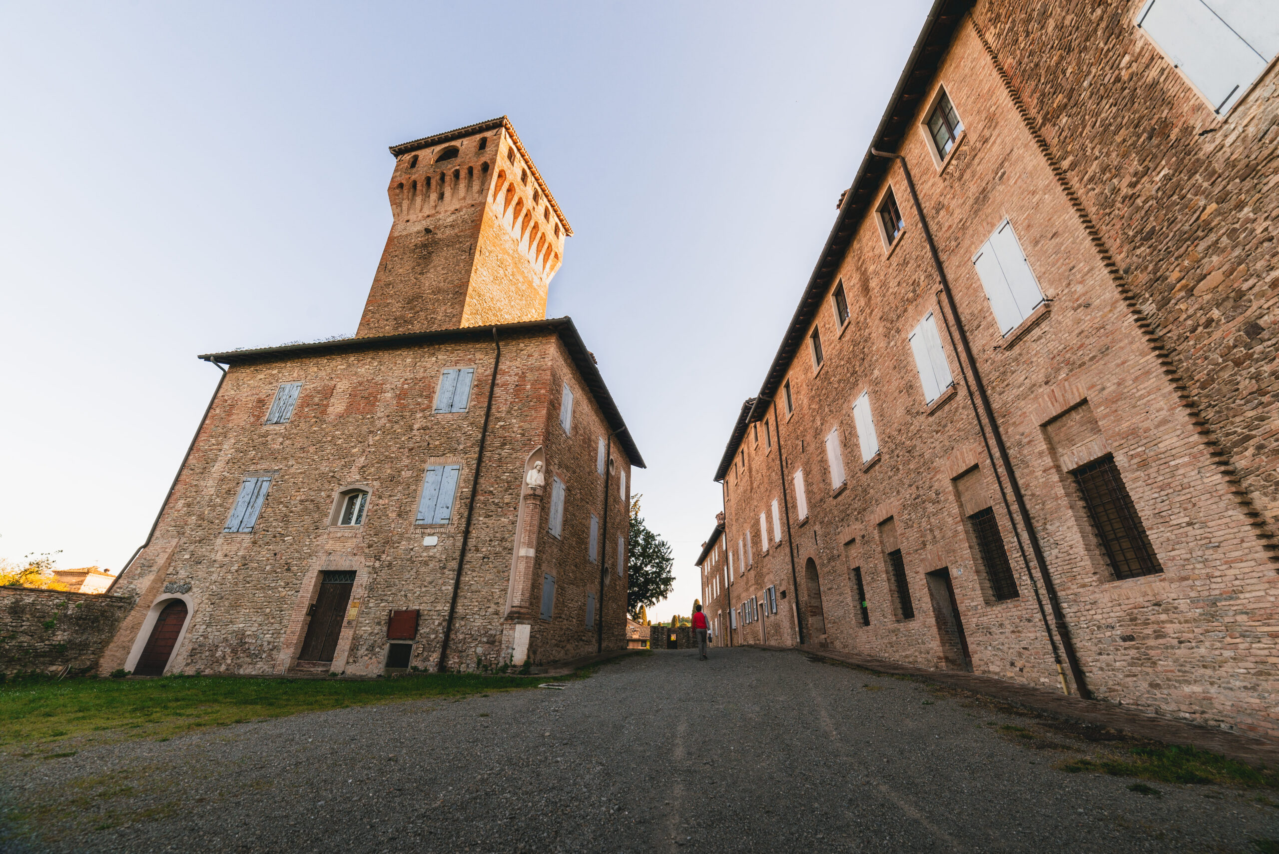
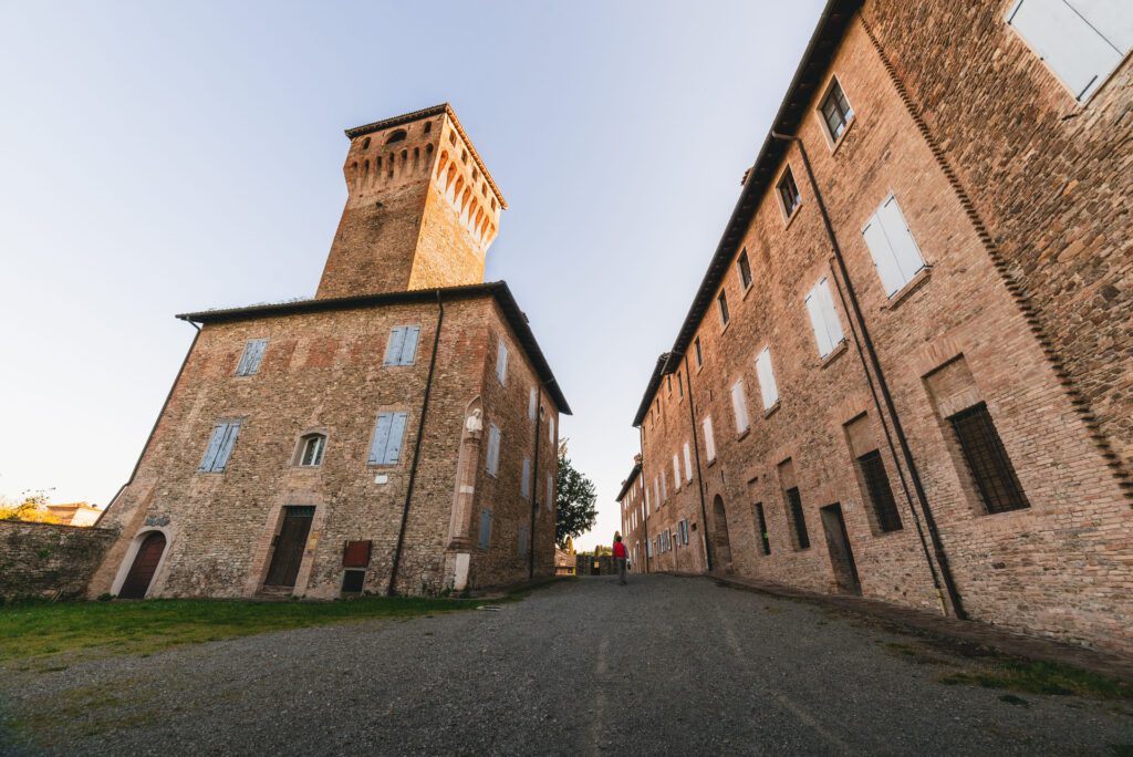
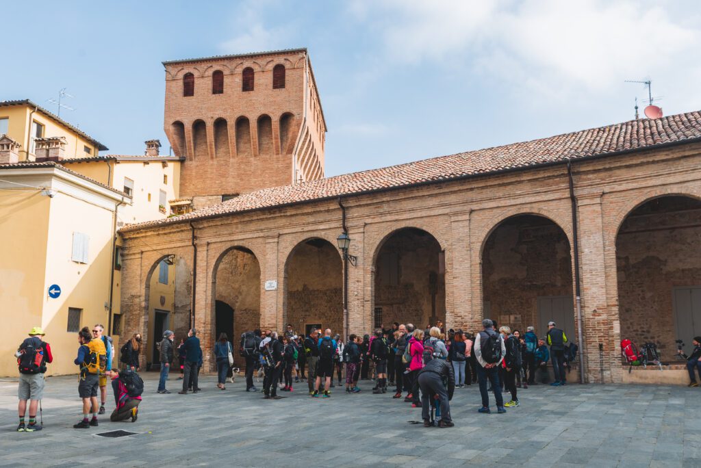
The beginning of the Camino could not know a more evocative place. We are in Vignola, in the Piazza dei Contrari. Our gaze glued to the perfectly preserved castle evokes times long gone. There is silence; we have already moved away from the whirlwind of life.
The stage is one of the longest but almost entirely flat. Leaving the Rocca, we follow the left bank of the Panaro River to Spilamberto, where we will find the second castle-the Rocca Rangoni-. and a lively historic center. Spilamberto would have many stories to tell: one of the queens of the Gypsy people is buried at the municipal cemetery; the porticoes of Via Obici have seen the exuberant creativity of the Spilamberto people expressed; then there is the tradition of carousel riders, here are the most famous manufacturers of merry-go-rounds; not to forget that Spilamberto is the home of Traditional Balsamic Vinegar of Modena. Inside the Museum of the same name, it is possible to stamp the Credential and be enveloped in its intoxicating aroma.
Leaving Spilamberto we will walk a few kilometers on the plains and then find the hills again just before Castelvetro, one of the most fascinating ancient villages on the Camino. On the pavement of the square we find a checkers used during festivals and historical re-enactments. At the tourist office you can stamp your credential.
Before reaching the village one encounters rows of Grasparossa, one of the types of Lambrusco. In the autumn period, the leaves turning grasparossa red render a landscape worthy of the best impressionist paintings. The same rows of vines will accompany us all the way to Levizzano, this day’s destination, but first we will have the chance to stop at the magnificent Oratory of San Michele, in perfect Romanesque style. From that place of spirituality we can run our eyes still among the rows of Grasparossa and imagine the time of the grape harvest.
Another castle awaits us in Levizzano, and inside it is the Rosso Graspa Museum dedicated to peasant culture and the history of Lambrusco.
This first stage is rich in history, castles and towns with a well-preserved historic center. The landscape is characterized by the presence of the Panaro River and in the final stage by rows of Lambrusco Grasparossa.
Water on the route:
Vignola, in Piazza dei Contrari, starting point – Spilamberto, at the exit of Palazzo Rangoni intersection with Via Obici – Flavor Kiosk – Castelvetro, in the old town – Levizzano, at the foot of the castle
Must-see:
Vignola: Castle – Chiocciola staircase inside Palazzo Barozzi – Historic center with Via Bonesi (double arcade) – Acetaia Comunale; Spilamberto: Rocca Rangoni – Historic center – Torrione – Archaeological Museum with Pilgrim skeleton with Camino di Santiago shell – Balsamic Vinegar Museum; Castelvetro: Medieval village and Piazza Roma with open-air checkers/chessboard – Oratory of San Michele; Levizzano: Castle – Rosso Graspa Museum – Campo San Rocco (former Napoleonic cemetery).
Food and wine not to be missed:
Vignola: cherries, especially Moretta di Vignola; Spilamberto: Balsamic vinegar – Amaretti di Spilamberto – Nocino; Castelvetro and Levizzano: Lambrusco Grasparossa.
TAPP 02
Stage 02: Levizzano to Pieve di Trebbio
Length: 23km;
Height difference: +970mt, -650mt;
Walking time: 7 hours
Difficulty: challenging
Dirt: 65%/ Asphalt: 35%
On the second stage we encounter fascinating landscapes. Leaving the village of Levizzano Rangone, we climb to reach Mount Three Crosses. A fascinating and mysterious place with deep symbolic meaning. The gaze runs freely, 360° over the surrounding landscape. The Po Valley seems like the great container of productive life, but it is now far away; we are on the clay gullies that introduce the hills before meeting the Apennines.
From time to time a bell tower, witness to a community that does not abandon its territory, that resists despite difficulties, that does not want to lose touch with traditions. The villages of Denzano and that of Villabianca bear witness to this. In both of them we find a facility with reception and catering services.
The landscape is already different than yesterday. The rows of Grasparossa have given way to gullies, attractive clay conformations, but poor in nutrients and impossible to work. Only the vineyard seems to defy the gray and thinness of the clay. Leaving the village of Villabianca, we walk again among the rows, small plots of brave local producers.
As we descend the hill, on our left we can make out an old furnace now enveloped by brambles. It was a brick factory, almost an example of industrial archaeology; today the imposing chimney is still clearly visible. Certainly a place of work for the families who lived in Marano sul Panaro during the 1900s. Of this town it is important to remember that the square, in the 1980s, was one of the first examples of pedestrianization and closure to traffic of an urban center.
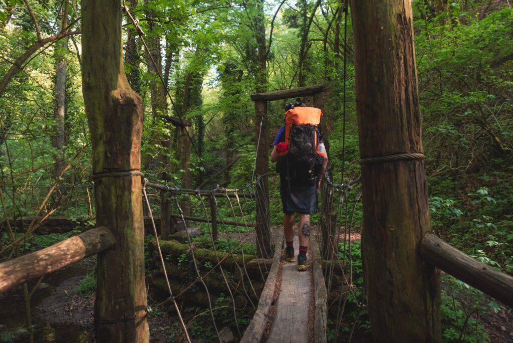
At Marano we find the Panaro River again, which we travel in the opposite direction from yesterday, toward Cimone. To crown the beauty of the stage, once we cross the Casona bridge, under which we can treat ourselves to a cool foot bath, we enter the Sassi di Roccamalatina Regional Park. We encounter the first woods of the Camino that will also accompany us on the next stage. After a succession of ups and downs we arrive at the magnificent Sentiero dei Ponticelli. Time seems to have stopped, we feel the sensation of having entered an enchanted world.
One more climb, during which the encounter with Uncle Theophilus reminds us of the importance of time governing the cycle of nature. Coming out of the woods, the gaze runs fast to caress the northern Apennine range, but it cannot help but stop on two spires that throw themselves forcefully upward, as if they want to fill a space of immense emptiness. They are the Sassi di Roccamalatina, one of the best-known places on the entire Union Trail.
Before we reach them, another surprise awaits us: the Roman-era parish church of Pieve di Trebbio. A place of rare beauty, perfectly preserved. We are at the end of the stage, surely tired with the desire to reach the place where we will spend the night, but it is worth stopping for a rest. It will not be wasted time that we devote to reflecting on the stage that is coming to an end. A mountain that looks like Calvary, then clay gullies, small villages that garrison the land, an oak tree overlooking a village square, the Panaro River that restores tired feet, then again the little bridges, Uncle Theophilus, an ancient parish church, and finally the Sassi di Roccamalatina.
A rich stage, we only miss the sighting of a peregrine falcon to remind us who we are.
Water on the route:
Levizzano (in the village and just outside, on Via Bedine, inside a park on the left) – Denzano (adjacent to the cemetery) – Marano sul Panaro (Piazza Matteotti – La Grama source) – Pieve di Trebbio, at the ancient Pieve.
Must-see:
Denzano: Tower and exterior of the church. Marano sul Panaro: Piazza Matteotti with oak tree and La Grama fountain. Pieve di Trebbio: ancient Romanesque parish church. Borgo di Sopra: view of the Sassi and climb (recommended) to Sasso della Croce. (Consider whether to postpone it until the following morning – stage No. 3 is definitely shorter)
Food and wine not to be missed:
From Marano onward, all the way back to Vignola, we find ourselves in an area where the cuisine offers unforgettable dishes: Tortellini in broth, Tortelloni with ricotta and herbs, Lasagna alla Bolognese, Tigelle or Crescentine and Gnocco Fritto accompanied by cured meats (above all Modena PDO ham), typical cheeses and the ever-present “pesto”: a condiment made with lard and herbs perfect for stuffing tigelle. The most unusual food found only in these areas is Borlengo, a pastry that is eaten with the hands traditionally topped with lard, of course!
TAPP 03
Stage 03: from Pieve di Trebbio to Zocca
Length: 17.7 km
Elevation gain: +790; -510;
Travel time: 6 hours
Difficulty: Medium
Dirt: 70% / Asphalt: 30%
It is the shortest stage; this allows us to devote part of the morning to visiting the ancient Pieve di Trebbio and, more importantly, to climbing the Sasso della Croce (for both inquire about days and times of opening). The climb up the sasso is easier than it may seem and is done in total safety. When you reach the summit all you can do is remain in silence, contemplate the infinite and marvel at the beauty of the landscape.
The third stage is characterized by chestnut forests, scenic places and small villages, a surprisingly evocative mix. In the hamlet at the foot of the Sassi we find the Alto Forno Impasti Agresti, a truly unique place worth visiting. Drinking coffee at one of the outdoor tables is truly a rewarding experience.
The trails are those of the Sassi di Roccamalatina Regional Park, carefully maintained and marked. A quick descent takes you to the Mulino della Riva, a picnic area so named because of the presence of a largely destroyed old mill. In the little house in the center of the meadow you can stamp your credential. It would be worth a stop but the stage has just begun and more kilometers and more climbs await us. The first of which takes us to Castellino delle Formiche, where there is a welcome point open on weekends or holidays. The name of the hamlet seems to have nothing to do with that cute category of insects, but to be a mispronunciation of the adjective formidable.
Chestnut woods guide us toward Samone and then take us to Cisterna Mountain where we can take a break and admire a breathtaking view from a very intimate spot not far from the picnic area. On Mt. Cistern we also find a particularly popular water point.
Zocca is not far away, but the ancient village of Montalbano, perfectly preserved and known for its imaginative Christmas cribs, awaits us. Those who wish can stop and break the stage, knowing that the next day will be at least a couple of kilometers longer.
Those who decide to continue can choose whether to go as far as the Hostel of San Giacomo or stay in Zocca, in the birthplace of Vasco Rossi. In either case, we leave Montalbano and head to the Sanctuary of Verucchia, the most religious place on the entire Union Way. Beyond its vocation related to spirituality, the Sanctuary is located in a very evocative place.
At the beginning of the village we encounter a fork in the road that forces us to choose between stopping in Zocca or reaching the hostel. In the first case we can play the card of a meeting with Vasco Rossi, if we choose the ancient hospice of San Giacomo we will spend the night in a structure built close to the forest, with paths that lead us to explore a real open-air museum with numerous wood sculptures.
In Zocca we will spend the next day there anyway.
The meeting with Vasco is only postponed!
Water on the route:
Borgo di Sopra, near the oratory of Madonna dei Sassi. Monte Cisterna in the picnic area at the foot of the little church of the Alpini. Montalbano, at the exit of the village. Verucchia, at the foot of the shrine
Must-see:
Pieve di Trebbio: Ancient Romanesque parish church with adjacent baptistery (open on holidays). Borgo di Sopra: Sassi di Roccamalatina rocks with ascent to Sasso della Croce (wonderful view). Castellino delle Formiche: Tower/belfry and the remains of the castle walls. Samone: with small detour you can enter the ancient area. Monte Cisterna: Picnic area and small church dedicated to Our Lady of Providence.
Montalbano: Well-preserved ancient village, nativity scenes visible I any time of the year. Zocca: famous for being the birthplace of Vasco Rossi.
Food and wine not to be missed:
The area is uniformly distinguished by Tigelle (here they are called Crescentine-the tigelle are the molds where they are baked) and Gnocco Fritto, accompanied by a riot of cured meats, cheeses, chicken cacciatore and jams (look for locally produced ones). When it’s mushroom season, don’t forget porcini dishes, among them tagliatelle. Also in season, we recommend chestnuts and marroni di Zocca, cooked and cooked in a variety of ways. Also, do not miss the ciacci con ricotta, made with chestnut flour.
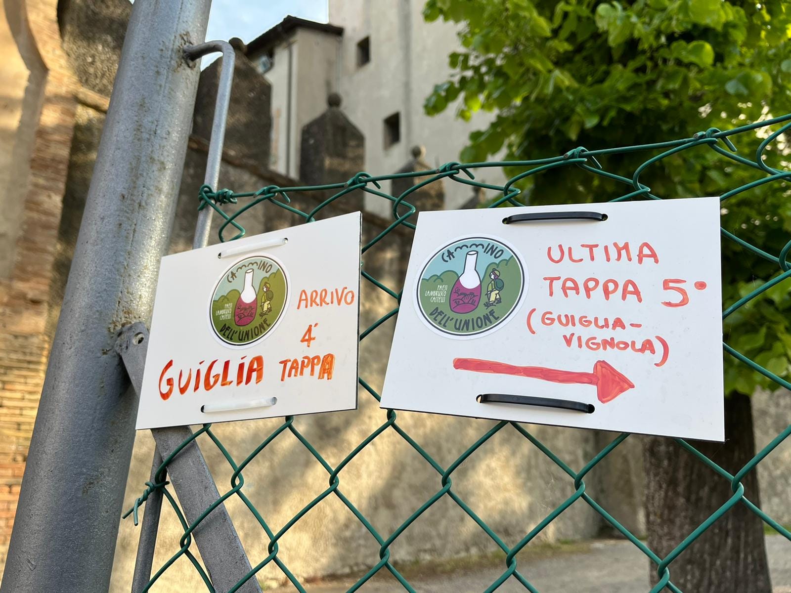
TAPP 04
Stage 04: Zocca to Guiglia
Length: 22.1km
Height difference: +461, -804;
Walking time: 6.30 hours
Difficulty: medium
Dirt: 50%/ Asphalt: 50%
After reaching the highest point of the path, the descent to Vignola begins. Leaving the ancient hospice of San Giacomo, one encounters the Treppi della Ruzzola. This is the name given to the playing field dedicated to the throwing of the ruzzola, a wooden disc that resembles a wheel of pecorino or caciotta cheese. It is a very old game of popular tradition and throughout history was outlawed or banned on more than one occasion because it was considered gambling or dangerous to people’s safety.
In less than an hour’s walk you reach Zocca, the birthplace of Vasco Rossi. On the main street, store and bar windows display phrases from his best-known songs. At certain times of the year it is not uncommon to meet him at the Bibap Bar located at the exit of the town. His presence runs fast from mouth to mouth, and groups of people often gather waiting for an autograph or photo.
After Zocca, one finds woods characterized by the majestic presence of chestnut trees that give way to cultivated fields or small villages that catch the eye. This will be the case for Zocchetta and further on for Montecorone. In Zocchetta, having found the main road again, we encounter a church with a portico. For those who want to visit it in nearby houses, you can contact the volunteers who take care of cleaning and maintenance and occasionally give the opportunity to try their hand at ringing the bells.
Upon arriving in Montecorone after a visit to the village, we set out for the Sasso di Sant’Andrea, a new rocky conformation of extreme beauty after the Sassi di Roccamalatina. An isolated place, off the tourist routes, marked by a mysterious charm. A stop at the top of the rock is not to be missed. Ancient traditions claim that this place has healing powers, all the more reason to treat ourselves to a stop that will restore the energy spent during the Camino. We will certainly be able to admire a wonderful panorama overlooking the village of Montecorone.
Leaving Sasso di Sant’Andrea we descend again, immersed in nature generous with glimpses to immortalize. From time to time cultivated fields and farmers at work. We wade along a stream, skirting it before reaching the Selva di Monteorsello. We walk on a dirt road flanking a stream and ascend to the hamlet of Monteorsello. In the small group of houses we find a church with a tall bell tower towering above the other buildings; it happens in other places too, but the particular shape of the hamlet accentuates the feeling.
Zocca (at the start) – Montecorone (in the village) – Monteorsello – (in the village) – Casa Galassi – Guiglia (in the village)
Must-see:
Zocchetta: ancient hamlet. Montecorone: ancient hamlet with small panoramic square and Sasso di Sant’Andrea. Monterosello: ancient hamlet. Guiglia: castle and oratory of the Blessed Virgin of St. Luke, which reproduces in reduced size the shrine of Bologna.
Food and wine not to be missed:
If you have not already done so, try the classics of Modenese cuisine, above all tortellini in brodo. Guiglia, however, is the land of borlenghi and it would be unforgivable not to try at least one!
TAPP 05
Stage 05: Guiglia to Vignola
Length: 20.9km;
Height difference: +258mt, -586mt;
Walking time: 6 hours
Difficulty: Easy
Dirt: 57%/Asphalt: 43%.
We are on the last leg of this short, but intense, walk. The departure is from Guiglia, and after the first kilometer, although we are walking on asphalt, we will find hills, cultivated fields or fields used for grazing. The landscape is typically agricultural and it is not uncommon to encounter a flock of sheep. For a few kilometers we walk in the province of Bologna to reach Castello di Serravalle, an impeccably preserved village to which a visit is due. For a stretch we found again the rows of vines, this time, however, not of lambrusco, but of pignoletto or barbera typical of the hills of Bologna.
We return to Modena territory as we approach another village, that of Savignano Alto. The landscape becomes wilder and the gullies we had already encountered during the second stage reappear. Those between Castello di Serravalle and the village of Savignano Alto, at Spazzavento, are truly impressive and inevitably capture our curiosity. But it is not only the clay gullies that will intrigue us. On the ground or in the trees it will be easy to encounter fruits we have never seen before, they look like oranges with curled skin. Instead, they are those of the maclura pomifera, native to the United States, also known as Texas mulberry. The fruits are not edible! Although they are not poisonous, it is best not to eat them; they can cause vomiting or other discomfort.
Before reaching Savignano Alto the badlands give way to rolling hills still marked by rows of vines. The area is particularly devoted to viticulture, and there is no shortage of interesting farms producing excellent wine. In the distance, as if it were a gateway to the plains, we catch a glimpse of the 3 towers of the Castle of Vignola, the place from which we started, but more importantly now, the final destination of our Walk.
The village of Savignano Alto is also a postcard to cherish in memories. We cannot miss a visit that takes us to a beautiful terrace where we find the church and bell tower. After that we descend to reach the village of Savignano and find the Panaro River again, which will take us to Vignola.
Walking over the bridge that crosses the watercourse we will have before our eyes the magnificent Rocca di Vignola fortress. We cross over the crosswalk, go around the castle, walk under the arcades and turn left to pass under the clock tower.
Let’s take a breath.
We are here.
In 5 days we went from the plains to the mountains, we walked among rows of Lambrusco and chestnut woods and encountered centuries-old oaks; we marveled at places that nature has given us without asking anything in return except to preserve and guard them. Thanks to the slowness of our steps we got to know an area rich in history, good food and genuine smiles.
Now we can celebrate the arrival at the goal. Each in his or her own way. Some in silence, some with a good glass of Grasparossa, and some hugging fellow travelers.
We thank you for walking, for bringing your story and your energy to this land. We thank you for every step you have taken and every word you have spoken. Even for your silences. Yes, we thank you for the silences you have been capable of, they are the ones that have allowed you to listen to the tale of the hills, the woods, the flowing river and boulders that look like motionless giants watching over the land.
Those silences, with the thousands of steps you have left on the ground, are a testimony to your passage, a declaration of love for all the Paths of Life.
Water on the route:
Guiglia (square in center of town and near the castle) – Castello di Serravalle (after entering the town through the only gate, on the square at the end of the small village) – Savignano Alto and Savignano – Vignola (p.za dei Contrari arrival of the Walk).
Must-see:
Castello di Serravalle: Borgo Antico Savignano Alto: Borgo Antico. Savignano sul Panaro: Museum of the Venus and the Elephant. Vignola: Castle – Scala a Chiocciola – Old Town and Via Bonesi – Acetaia Comunale.
Food and wine not to be missed:
Mention has already been made of the fresh homemade pasta dishes, tigelle (crescentine) and gnocco fritto accompanied by traditional cheeses and cured meats, above all Prosciutto di Modena. The move to Bolognese land allows us to mention Mortadella di Bologna and Pignoletto dei Colli Bolognesi in sparkling or still versions. Before heading back home, if you want to take some traditional food with you, you are spoiled for choice, among products that are part of Italian food and wine excellence: Parmigiano Reggiano – Prosciutto di Modena – Mortadella di Bologna – Cherry jams – Traditional Balsamic Vinegar – Cherries from Vignola (in season) – Tigelle (already cooked or to be cooked) – Lambrusco Grasparossa di Castelvetro – Pignoletto dei Colli Bolognesi – Tortelloni or Tortellini at artisan workshops – Amaretti di Spilamberto – Torta Barozzi.

Journey diaries
Insights
Cammino dell'Unione
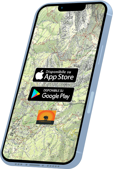
With the free Cammini d’Italia app, you can plan and walk Cammino dell’Unione safely, being able to plan the stages in detail and walk the route thanks to the integrated GPS technology that supports you in orientation during your adventure.
⠀Inside the app you will find many other paths present in Italy. Thanks to the georeferenced tracks of many routes, you will be able to study the itinerary that suits you best and also download the GPX tracks of the individual stages offline.
The app also includes a complete digital map of all the paths surveyed to date on our portal, giving you a wide range of choices among the many paths in the Belpaese.
⠀⠀
Cammini d’Italia is the perfect app for those who want to explore the beauty of Italy on foot, discovering hidden places surrounded by nature. Download it for free today and start planning your next adventure!
⠀
⠀
 ⠀⠀⠀
⠀⠀⠀