
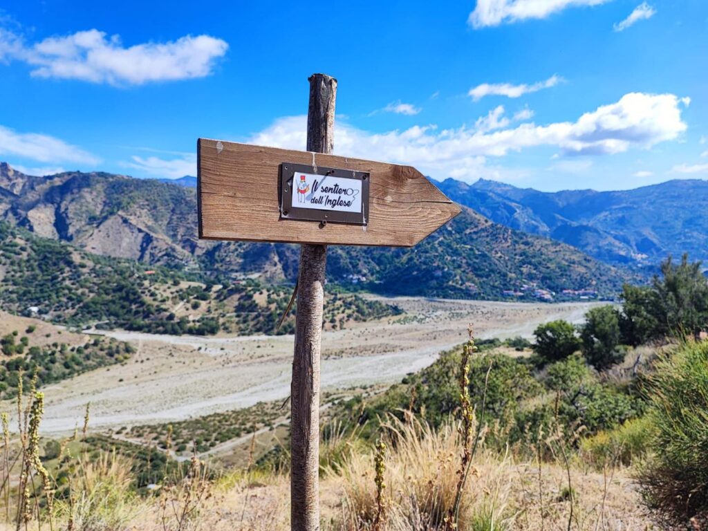
Sentiero dell'Inglese
An evocative 7-day walk in a land of yesteryear, among enchanting Greek-speaking villages, majestic centuries-old olive groves, and fascinating Fiumare.
The Sentiero dell'Inglese is a fascinating one-week journey through a region of ancient charm, among enchanting Greek-speaking villages, majestic centuries-old olive groves and fascinating waterways. To enter the true essence of Greek Calabria, a land as warm and welcoming as its people, as joyful and cheerful as its traditional dances and music.
HISTORY
The path was created by taking a cue from the diary of a 19th-century English traveler, Edward Lear, who walked through Greek Calabria between July and September 1847
WATER SOURCES.
Water sources are present in the villages of departure and arrival of all the STAGES. A constant presence of water is not guaranteed along the paths at all times of the year
STAGE-BY-STAGE SERVICES
SERVICES PRESENT STAGE BY STAGE
Are there any supermarkets?
Pentedattilo – No
Bagaladi – Yes, 2 Minimarkets, 2 tobacconists, some Bars,
1 POSTAMAT counter
Amnedolea – No
Bova – Yes, 2small stores, 2 tobacconists, some bars,1 POSTAMAT counter
Palizzi – Yes, 1 small workshop
Staiti – Yes, 1 small workshop
Are there any pharmacies?
Pentedattilo – No
Bagaladi – Yes
Amnedolea – No
Bova – Yes
Palizzi – No
Staiti – Yes
SIGNAGE
Currently, the Trail is not completely marked, but a good part of the STAGES are marked with white/red markings and metal plates depicting the Sentiero dell’Inglese logo. In any case, we recommend that you use the Cammini d’Italia App or download the gps tracks by requesting them on the site with the appropriate form.
DANGERS
When departing from Pentedattilo, it is necessary to notify a shepherd who grazes the flocks along the trail, contact the STAGE manager.
ROAD BOTTOM.
25km out of 110km total
CREDENTIALS
Departing from Pentedattilo is possible the Englishman’s safe-conduct where you can collect the stamps of the villages crossed that will allow the walker to receive in Staiti theCertificate of Walk.
TENT WALK
There are no dedicated areas, but by asking the STAGE managers, a solution can be found.
CONTACTS
Ass. Sentiero dell’Inglese – Naturaliter Trekking and Mediterranean Hospitality – Compagnia dei Cammini
E-mail: info@naturaliterweb.it
Phone: +39 347 30 46 799 – +39 328 90 94 209
STAGE 01
STAGE 01: Pentedattilo – Bagaladi
Length: 18 km
Height difference: 730+/560-
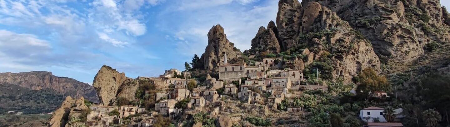
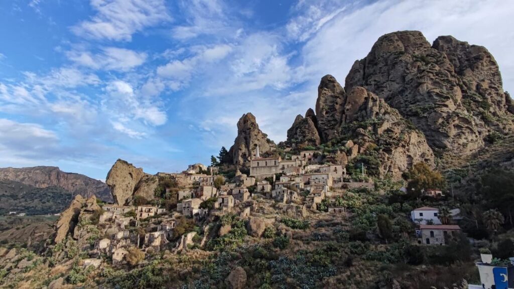
The walk begins in the ghost town of Pentedattilo, a small village set in a giant conglomerate fortress in the shape of an outstretched hand, the sight of which will be with us for a long time along the way. Passing through olive groves, almond orchards and lots of Mediterranean scrub, and along some stretches of small, often dry rivers, we will reach Bagaladi, a charming little village nestled on the Tuccio River. Where it will be possible to find hospitality and catering, obviously with prior reservation.
The village of Bagaladi houses within the church of St. Theodore Martyr a magnificent 16th-century marble group that is undoubtedly worth a visit.
STAGE 02
STAGE 02: Bagaladi – Amendolea di Condofuri.
Length: 18 km
Height difference: +420/-710
We start from the square with the fountain depicting a millstone (the village is renowned for its abundant oil production) and head towards the Fiumara del Tuccio (at some times of the year it may be difficult to ford the Fiumara, ask the stage manager for info before departure), after crossing it we climb up to the hamlet of San Lorenzo, we cross it admiring the majestic monumental Elm tree that has been shading the hamlet square for over 500 years. Shortly after leaving San Lorenzo we reach the hamlet of San Pantaleone, which preserves inside the chapel church a 12th-century Byzantine icon depicting a black Madonna holding Jesus in her arms. Past San Pantaleone we come to skirt the almost always dry Condofuri stream after crossing the contrada Grotte, a small hamlet of Condofuri now almost uninhabited.
Finally, walking for a stretch along the bed of the Condofuri stream we finally reach Fiumara Amendolea, which is the last obstacle to overcome before reaching the village of the same name.
(The Fiumara Amendolea is one of the watercourses with the greatest flow in the area, which is why at certain times of the year it is inadvisable to try to cross it; there are alternatives to avoid fording, always ask the STAGE manager before departure).
STAGE 03
STAGE 03: Amendolea – Bova
Length: 20 km
Height difference: +1100/-530
We leave from the Il Bergamotto farm and return to the riverbed of the fiumara, which we will have to ford again in the direction of the retaining wall on the opposite bank of the fiumara, we enter through the opening in the concrete wall and begin to climb amidst the olive groves until we arrive under a rocky ridge overlooking the olive grove, we intercept thanks to little man a small path up the rock face until we reach a fence, where a craft gate allows us to exit and reach a very rough forest track that takes us to the ridge, where, taking care to close all gates craft or otherwise, we take a convenient beaten road that we follow until we cross the asphalt.
Here, passing to the right of the small vineyard, we intercept a small path that passes amidst cistus shrubs and zigzags up to a dirt road that we travel for less than a kilometer and immediately after passing one of the classic bunk-hole we intercept the path aided by the presence of black water pipes, we follow the path that climbs amidst prickly pear plants until we intercept the paved road that in about half an hour takes us to Gallicianò.
After visiting the village and its very interesting peculiarities concerning language and religion above all, we take trail No. 128, which in about an hour makes us reach the riverbed of the Amendolea River at loc. Focolìo, and after fording the river again (if necessary), we reach the opposite bank, where the entrance to the trail is indicated by a park signpost.
Climbing up the marked path, crossing first a grove of holm oaks and then a long expanse of Mediterranean scrub, after a good hour of ascent we will intercept a paved mule track that will lead us to the paved road that in about 20 minutes will take us to the capital of the Grecanica area, Bova.
STAGE 03bis
STAGE 3bis : Amendolea to Bova
Length: 5 miles
Height difference: +700/
During periods of intense heat or periods when the flow rate of the Amendolea River makes fording difficult and dangerous, we recommend reaching Bova via the Aspromonte Naz d’Aspromonte Park Trail 152.
Leaving from the agritourism Il Bergamotto and following the red-and-white CAI signs we will reach Bova in about three hours, passing through ancient cultivated fields, olive groves interspersed with majestic oaks, passing through a picturesque district called Monastero,because it seems that a monastery built during the period of Basilian monasticism stood there.
Continuing to follow the red-and-white flags after a few kilometers we will begin to encounter the first rural dwellings of Bova; we will leave the dirt road for asphalt and we will already be in sight of Bova, which rises above us like a veritable eagle’s nest. From here, following the asphalt road in less than an hour we will reach blue Bova (as Lear calls it in his journal).
STAGE 04
STAGE 04 Bova- Monte Grosso – Bova (loop)
Length: 20 km
Height difference: +800/-800
We start from Piazza Roma, in front of the town hall, and head toward the infamous Locomotive and exit the town going in the direction of the sports field. Reaching the field and shortly after passing the disused CFS barracks we take the marked path to our right. We begin to climb the rocky ridge along an ancient paved mule track immersed in the Mediterranean scrub from which we can enjoy a spectacular view of the Rocca di Bova that stands out majestically immersed in the deep blue of the sea that frames it.
We alternate between sections of trail and stretches of asphalt until we reach the fields of Bova (1200 asl) where the fascinating pine forests lead us to the viewpoint of Monte Grosso (1150 asl) where we can enjoy a unique view of the Amendolea valley and the Ghost Village of Roghudi and Chorio di Roghudi.
Returning on the same path to a tin forest house, we follow the forest road that continues to our left and reach in San Salvatore forest hut, an equipped area with water presence.
Descending along the asphalt road that leads back to Bova we begin to return, and after about 3 km, having passed a small votive shrine dedicated to St. Leo, we enter a gate made of electrowelded mesh (to be closed again) and take the wide dirt roadthat passes through loc. Kalo Jero which in a couple of hours will take us back to Bova near the sports field, from here in a few minutes we return to Piazza Roma.
STAGE 05
STAGE 05 Bova – Palizzi
Length: 13 km
Height difference: +300/-870
We start from Rome Square and head to the area called “Borgu.” and following the trail signs we leave the village along an old road, in long stretches still well paved, that leads to the Valle dei Mulini, an agricultural district of Bova where many Greek-type water mills once stood, some of which are still clearly visible.
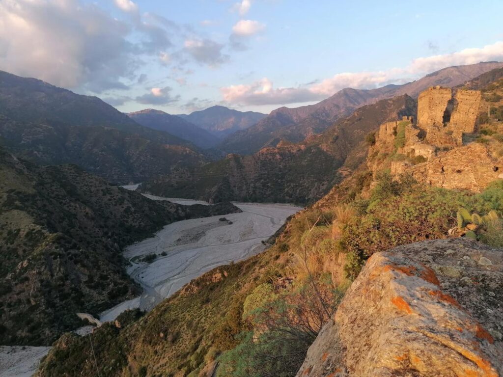
Reaching the bed of a small stream we follow it until we reach the paved road, which we take and begin to climb, pass some small hamlets and reached Loc. Cavaddhu we begin to descend gently toward Palizzi, and after a couple of hours or so we will begin to catch a glimpse of the castle overlooking the fortress of Palizzi, which we will reach shortly thereafter, entering it by walking through the narrow medieval alleys of the village.
STAGE 06
STAGE 06 Palizzi – Pietrapennata – Staiti
Length: 22 km
Height difference: +900/-800
We start from the small church square and leave the village by walking for 2 km along the paved road that leads to Pietrapennata, we take the road that on our left leads to the sulphurous waters and we follow it for about 800 m. On our right we meet a marked gate that we pass and that makes us take the marked path on our left, we follow it until we cross again the asphalt road that we will follow for 4 km to Pietrapennata.
The village of Pietrapennata is home to a valuable 15th-century marble statue inside the mother church; unfortunately, the church is not always open.
Leaving Pietrapennata we go in the direction of the cemetery, and a few dozen meters before we get there we take the marked path to our left. We follow it passing among holm oaks, ferns and wild pear trees. We reach the ruins of Santa Maria dell’Alìca, a complex of religious buildings built from the 12th cent.
We continue on the path that after a small, somewhat steep section leads us onto a forest road. Going up it we pass the equipped area “Falcò” and we enter the ilex forest along the dirt road for 2 km, we intercept a small path that goes up at a large sharp bend and coming out of the ilex forest the summit of Monte Cerasia appears before us (dir. North).
We descend slightly and then, in the midst of a sea of ferns we go back up the beaten path until we reach a more comfortable forest road that after a few hundred meters we leave to begin the ascent to the summit, which we reach in a few minutes and which will give us a boundless horizon over much of the southern coast of the province of Reggio C.
After enjoying the wonderful panorama offered by the 1000 m asl of Mt. Cerasia, we retrace our steps to the picnic area “Falcò” where we can refuel with water.
After that, driving along the dirt road we will reach the village of Staiti in about 45 minutes.


Journey diaries
Listen to our podcast

Sentiero dell'Inglese
With the free Cammini d’Italia app, you can plan and walk Sentiero dell’Inglese < /span>safely, being able to plan the stages in detail and walk the route thanks to the built-in GPS technology that supports your orientation during your adventure.
⠀Inside the app you will find many other paths present in Italy. Thanks to the georeferenced tracks of many routes you will be able to study the itinerary that suits you best and also download the GPX tracks of the individual STAGEs offline.
The app also includes a complete digital map of all the paths surveyed to date on our portal, giving you a wide range of choices among the many paths in the Belpaese.
⠀⠀
Cammini d’Italia is the perfect app for those who want to explore the beauty of Italy on foot, discovering hidden places surrounded by nature. Download it for free today and start planning your next adventure!
⠀
⠀ ⠀⠀⠀
⠀⠀⠀